Trail Walking Villard-de-Lans - Col vert - Fauge - Photo
© OpenStreetMap contributors
Length
Length
12.1 km
Max alt
Max alt
1746 m
Uphill gradient
Uphill gradient
881 m
Km-Effort
Km-Effort  
24 km
Min alt
Min alt
1091 m
Downhill gradient
Downhill gradient
881 m
Boucle
Boucle
Yes
Creation date :
2019-01-15 18:12:57.29
Updated on :
2021-10-30 14:56:09.971

(0 Reviews)

Walking
Walking
5h00
Difficulty : Easy

Scan this QR Code to open this trail in the SityTrail application

FREE GPS app for hiking

Logo SityTrail SityTrail

IGN / Geographical institutes

Download SityTrail from the App Store Download SityTrail from Google Play

Logo SityTrail SityTrail World

The world is yours!

Download SityTrail from the App Store Download SityTrail from Google Play Download SityTrail on Huawei AppGallery

About

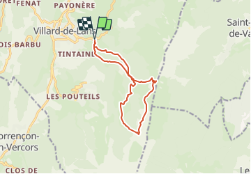
Trail Walking of 12.1 km to be discovered at Auvergne-Rhône-Alpes, Isère, Villard-de-Lans. This trail is proposed by jacky.26sp.

Description

Du parking Les Cochettes, nous nous dirigeons en direction du Pont de l'amour pour rejoindre la cabane de Roybon. Nous franchissons le portillon pour traverser sous-bois et prairies. (Vue sur Villard de Lans). Nous suivons le sentier qui grimpe en lacets jusqu'aux rochers pour déboucher au Col Vert (Point culminant 1766 m). Nous descendons par le sentier Peronnard avant d'emprunter la Combe Charbonnière. Bientôt nous arrivons à la Bergerie de la Fauge pour retrouver la cabane de Roybon. Nous prenons la direction des Plâtres puis nous traversons une belle forêt pour retrouver le chemin des Cochettes.

Elevation profile

Photos

Positioning

Country:
France
Region :
Auvergne-Rhône-Alpes
Department/Province :
Isère
Municipality :
Villard-de-Lans
Location:
Unknown
Start:(UTM)
702048 ; 4993640 (31T) N.

Trails nearby

Trail Walking Villard-de-Lans - villard col des 2 soeurs - Photo
Walking
arnaudconde

Walking

Medium
(1)
Villard-de-Lans, Auvergne-Rhône-Alpes, Isère, France
7.7 km | 13.8 km-effort
2h 45min
Yes
Trail Walking Lans-en-Vercors - Le Pic saint michel - Photo
Walking
patjobou

Walking

Easy
(1)
Lans-en-Vercors, Auvergne-Rhône-Alpes, Isère, France
6.5 km | 13.2 km-effort
2h 38min
No
Trail Snowshoes Autrans-Méaudre en Vercors - Le Gros Martel - Méaudre - Photo
Snowshoes
tracegps

Snowshoes

Medium
(4)
Autrans-Méaudre en Vercors, Auvergne-Rhône-Alpes, Isère, France
4.9 km | 8.4 km-effort
2h 10min
Yes
Trail Walking Villard-de-Lans - cabane de robon - Photo
Walking
Sylvie Mathiot

Walking

Very easy
(1)
Villard-de-Lans, Auvergne-Rhône-Alpes, Isère, France
10.2 km | 15.8 km-effort
5h 25min
Yes
Trail Walking Lans-en-Vercors - 38 pic st michel - Photo
Walking
himba26100

Walking

Easy
(1)
Lans-en-Vercors, Auvergne-Rhône-Alpes, Isère, France
8.7 km | 17.3 km-effort
5h 16min
Yes
Trail Snowshoes Lans-en-Vercors - Le Pic Saint-Michel en raquettes (2012) - Photo
Snowshoes
tracegps

Snowshoes

Medium
(2)
Lans-en-Vercors, Auvergne-Rhône-Alpes, Isère, France
8.4 km | 17.3 km-effort
5h 0min
Yes
Trail Mountain bike Corrençon-en-Vercors - Grande Traversée des PréAlpes à VTT : Corrençon en Vercors - La Chapelle en Vercors - Photo
Mountain bike
tracegps

Mountain bike

Difficult
(1)
Corrençon-en-Vercors, Auvergne-Rhône-Alpes, Isère, France
25 km | 36 km-effort
3h 30min
No
Trail Walking Villard-de-Lans - Le sentier Peronnard et le Pas de l'OEille - Photo
Walking
tracegps

Walking

Easy
(1)
Villard-de-Lans, Auvergne-Rhône-Alpes, Isère, France
13.7 km | 25 km-effort
6h 0min
Yes
Trail Walking Villard-de-Lans - Le Plateau du Cornafion 1906m - Photo
Walking
tracegps

Walking

Difficult
(1)
Villard-de-Lans, Auvergne-Rhône-Alpes, Isère, France
7.8 km | 17.7 km-effort
4h 30min
Yes


Close
My subscriptions