


18.11.03.Heimsbrunn mi Hochstatt et retour

ROPPJP
User
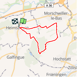

Length
11.5 km

Max alt
329 m

Uphill gradient
151 m
Km-Effort
13.5 km

Min alt
270 m

Downhill gradient
151 m
Boucle
Yes
Creation date :
2019-01-15 18:20:54.707
Updated on :
2019-01-15 18:20:54.707
2h21
Difficulty : Unknown

FREE GPS app for hiking
 SityTrail
IGN / Geographical institutes
SityTrail Plus
The world is yours!
About
Trail Walking of 11.5 km to be discovered at Grand Est, Haut-Rhin, Heimsbrunn. This trail is proposed by ROPPJP.
Description
à travers champs et forêt
Photos


Positioning
Country:
France
Region :
Grand Est
Department/Province :
Haut-Rhin
Municipality :
Heimsbrunn
Location:
Unknown
Start:(Dec)
Start:(UTM)
367132 ; 5287466 (32T) N.
Comments