Trail Mountain bike Picherande - Espace VTT FFC du Sancy - Circuit n°08 - Bois de Gayme - Secteur Picherande - Photo

Espace VTT FFC du Sancy - Circuit n°08 - Bois de Gayme - Secteur Picherande

 tracegps
tracegps

User

© OpenStreetMap contributors
Length
Length
5.5 km
Max alt
Max alt
1208 m
Uphill gradient
Uphill gradient
109 m
Km-Effort
Km-Effort  
6.9 km
Min alt
Min alt
1117 m
Downhill gradient
Downhill gradient
106 m
Boucle
Boucle
Yes
Creation date :
2014-12-10 00:00:00.0
Updated on :
2014-12-10 00:00:00.0

(0 Reviews)

Mountain bike
Mountain bike
30m
Difficulty : Easy

Scan this QR Code to open this trail in the SityTrail application

FREE GPS app for hiking

Logo SityTrail SityTrail

IGN / Geographical institutes

Download SityTrail from the App Store Download SityTrail from Google Play

Logo SityTrail SityTrail World

The world is yours!

Download SityTrail from the App Store Download SityTrail from Google Play Download SityTrail on Huawei AppGallery

About

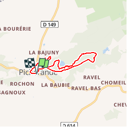
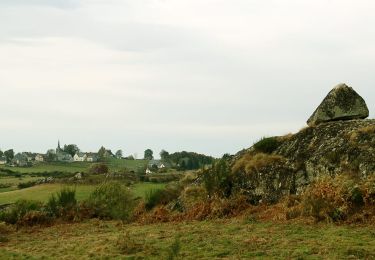
Trail Mountain bike of 5.5 km to be discovered at Auvergne-Rhône-Alpes, Puy-de-Dôme, Picherande. This trail is proposed by tracegps.

Description

Espace VTT FFC du Sancy - Circuit n°08 - Bois de Gayme - Secteur Picherande Circuit officiel labellisé par la Fédération Française de Cyclisme. Départ devant le camping du Sancy – Gayme. Circuit très facile combinant secteurs boisés et vallonnés entre les Monts Dore et les plateaux de l’Artense.

Elevation profile

Photos

Positioning

Country:
France
Region :
Auvergne-Rhône-Alpes
Department/Province :
Puy-de-Dôme
Municipality :
Picherande
Location:
Unknown
Start:(UTM)
481974 ; 5034530 (31T) N.

Trails nearby

Trail Mountain bike Picherande - Espace VTT FFC du Sancy - Circuit n°10 - L'Escudor - Secteur Picherande  - Photo
Mountain bike
tracegps

Mountain bike

Difficult
(1)
Picherande, Auvergne-Rhône-Alpes, Puy-de-Dôme, France
14.9 km | 19.8 km-effort
1h 10min
Yes
Trail On foot Saint-Donat - Bertinet - Photo
On foot
PRO

On foot

Easy
Saint-Donat, Auvergne-Rhône-Alpes, Puy-de-Dôme, France
7.9 km | 10 km-effort
2h 15min
Yes
Trail On foot Picherande - Le Lac Chauvet - Photo
On foot
PRO

On foot

Easy
Picherande, Auvergne-Rhône-Alpes, Puy-de-Dôme, France
13.2 km | 16.7 km-effort
3h 47min
Yes
Trail On foot Picherande - La Fontaine Salée - Photo
On foot
PRO

On foot

Medium
Picherande, Auvergne-Rhône-Alpes, Puy-de-Dôme, France
20 km | 29 km-effort
6h 41min
Yes
Trail On foot Chastreix - Chastreix+la réserve_Bois_dela_Masse - Photo
On foot
v.rabot

On foot

Easy
(1)
Chastreix, Auvergne-Rhône-Alpes, Puy-de-Dôme, France
9 km | 12.4 km-effort
2h 48min
Yes
Trail Walking Égliseneuve-d'Entraigues - boucle 10 km autour du lac chauvet - Photo
Walking
famillerudent

Walking

Difficult
Égliseneuve-d'Entraigues, Auvergne-Rhône-Alpes, Puy-de-Dôme, France
10.4 km | 13.4 km-effort
3h 33min
Yes
Trail Walking Picherande - Picherande  - Photo
Walking
GUIDE
antignacs

Walking

Very easy
Picherande, Auvergne-Rhône-Alpes, Puy-de-Dôme, France
6.2 km | 7.7 km-effort
2h 4min
Yes
Trail Walking Saint-Donat - St_Donat_Bertinet - Photo
Walking
GUIDE
jagarnier

Walking

Easy
Saint-Donat, Auvergne-Rhône-Alpes, Puy-de-Dôme, France
9.3 km | 12.1 km-effort
2h 45min
Yes
Trail 4x4 Picherande - Picherande - Photo
4x4
Martial Faulconnier

4x4

Very easy
Picherande, Auvergne-Rhône-Alpes, Puy-de-Dôme, France
7.4 km | 9.9 km-effort
34min
No


Close
My subscriptions