Trail Mountain bike Sainte-Foy-de-Peyrolières - Le GR 86 de Sainte Foy de Peyrolières à Aurignac - Photo

Le GR 86 de Sainte Foy de Peyrolières à Aurignac

 tracegps
tracegps

User

© OpenStreetMap contributors
Length
Length
74 km
Max alt
Max alt
455 m
Uphill gradient
Uphill gradient
1448 m
Km-Effort
Km-Effort  
92 km
Min alt
Min alt
234 m
Downhill gradient
Downhill gradient
1307 m
Boucle
Boucle
No
Creation date :
2014-12-10 00:00:00.0
Updated on :
2014-12-10 00:00:00.0

(0 Reviews)

Mountain bike
Mountain bike
7h00
Difficulty : Very difficult

Scan this QR Code to open this trail in the SityTrail application

FREE GPS app for hiking

Logo SityTrail SityTrail

IGN / Geographical institutes

Download SityTrail from the App Store Download SityTrail from Google Play

Logo SityTrail SityTrail World

The world is yours!

Download SityTrail from the App Store Download SityTrail from Google Play Download SityTrail on Huawei AppGallery

About

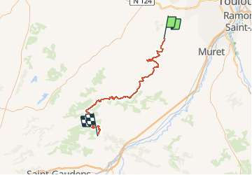
Trail Mountain bike of 74 km to be discovered at Occitania, Haute-Garonne, Sainte-Foy-de-Peyrolières. This trail is proposed by tracegps.

Description

Une partie du GR 86, au cœur de la Haute-Garonne, grâce à des tronçons relevés et mis bout à bout avec Mapsource. A vélo, la trace GPS est bien plus efficace que le balisage destiné aux piétons. Un sentier qui réussit à unir le maximum de pistes restantes dans ce pays vallonné. "GR" est un gage de qualité et de plaisir.

Elevation profile

Positioning

Country:
France
Region :
Occitania
Department/Province :
Haute-Garonne
Municipality :
Sainte-Foy-de-Peyrolières
Location:
Unknown
Start:(UTM)
349728 ; 4817506 (31T) N.

Trails nearby

Trail Walking Saiguède - Raide de Saiguède - Photo
Walking
tracegps

Walking

Difficult
(1)
Saiguède, Occitania, Haute-Garonne, France
19 km | 23 km-effort
4h 0min
Yes
Trail Walking Sainte-Foy-de-Peyrolières - RANDO-Ste Foy Téléthon 2012 - Photo
Walking
Polo-31

Walking

Easy
Sainte-Foy-de-Peyrolières, Occitania, Haute-Garonne, France
8 km | 9.3 km-effort
2h 2min
Yes
Trail Walking Sainte-Foy-de-Peyrolières - Lac et bois autour de Sainte Foy de Peyrolières - Photo
Walking
tracegps

Walking

Easy
Sainte-Foy-de-Peyrolières, Occitania, Haute-Garonne, France
9 km | 11.2 km-effort
2h 30min
Yes
Trail Walking Sainte-Foy-de-Peyrolières - Ste Foy de Peyrolières 13 Avril 2020 - Photo
Walking
daniel3157

Walking

Easy
Sainte-Foy-de-Peyrolières, Occitania, Haute-Garonne, France
16.4 km | 21 km-effort
4h 58min
Yes
Trail Running Saiguède - Raide de Saiguède - Photo
Running
tracegps

Running

Very difficult
Saiguède, Occitania, Haute-Garonne, France
19 km | 23 km-effort
2h 0min
Yes
Trail Walking Sainte-Foy-de-Peyrolières - Randonnée Sainte Foy de Peyrolières  - Photo
Walking
Fafou64

Walking

Sainte-Foy-de-Peyrolières, Occitania, Haute-Garonne, France
10.7 km | 12.9 km-effort
2h 39min
Yes
Trail Walking Saiguède - Saiguède belles vues - Photo
Walking
pidjam

Walking

Very easy
Saiguède, Occitania, Haute-Garonne, France
8.3 km | 10.5 km-effort
2h 0min
Yes
Trail Walking Empeaux - Empeaux circuit cross - Photo
Walking
pidjam

Walking

Easy
Empeaux, Occitania, Haute-Garonne, France
9.7 km | 12.5 km-effort
2h 40min
Yes
Trail Walking Saint-Thomas - st thomas long - Photo
Walking
pidjam

Walking

Easy
Saint-Thomas, Occitania, Haute-Garonne, France
12.1 km | 15.8 km-effort
3h 22min
Yes


Close
My subscriptions