Trail Walking Argelès-sur-Mer - chapelle St. Laurent - la cerigue - Photo

chapelle St. Laurent - la cerigue

 kaced66
kaced66

User

© OpenStreetMap contributors
Length
Length
3.1 km
Max alt
Max alt
287 m
Uphill gradient
Uphill gradient
35 m
Km-Effort
Km-Effort  
4.4 km
Min alt
Min alt
27 m
Downhill gradient
Downhill gradient
293 m
Boucle
Boucle
No
Creation date :
2014-12-10 00:00:00.0
Updated on :
2014-12-10 00:00:00.0

(0 Reviews)

Walking
Walking
50m
Difficulty : Very easy

Scan this QR Code to open this trail in the SityTrail application

FREE GPS app for hiking

Logo SityTrail SityTrail

IGN / Geographical institutes

Download SityTrail from the App Store Download SityTrail from Google Play

Logo SityTrail SityTrail World

The world is yours!

Download SityTrail from the App Store Download SityTrail from Google Play Download SityTrail on Huawei AppGallery

About

Trail Walking of 3.1 km to be discovered at Occitania, Pyrénées-Orientales, Argelès-sur-Mer. This trail is proposed by kaced66.

Elevation profile

Photos

Points of interest

Point of interest Argelès-sur-Mer - croisement  - Photo
kaced66
ARGELÈS-SUR-MER 
Point of interest Argelès-sur-Mer - arrivée sur la piste - Photo
kaced66
ARGELÈS-SUR-MER 
Point of interest Argelès-sur-Mer - point 2 - Photo
kaced66
ARGELÈS-SUR-MER 

Positioning

Country:
France
Region :
Occitania
Department/Province :
Pyrénées-Orientales
Municipality :
Argelès-sur-Mer
Location:
Unknown
Start:(UTM)
501623 ; 4707644 (31T) N.

Trails nearby

Trail Mountain bike Argelès-sur-Mer - la dujardin - Photo
Mountain bike
fine66

Mountain bike

Very easy
(5)
Argelès-sur-Mer, Occitania, Pyrénées-Orientales, France
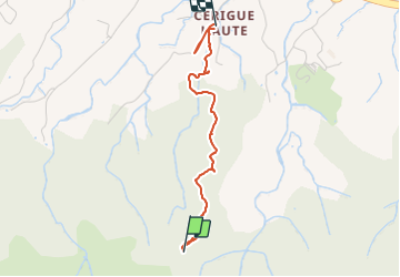
11.6 km | 18.7 km-effort
1h 11min
No
Trail Walking Collioure - Collioure-le racou - Photo
Walking
jeromelacoste

Walking

Medium
(1)
Collioure, Occitania, Pyrénées-Orientales, France
7.2 km | 9.3 km-effort
2h 1min
Yes
Trail Walking Argelès-sur-Mer - 66 ARGELES SUR MER - mas Christine, promenade dans les Albères, par les pistes,sentiers, entre les chênes lièges - Photo
Walking
jeff66

Walking

Medium
(2)
Argelès-sur-Mer, Occitania, Pyrénées-Orientales, France
7.4 km | 9.8 km-effort
1h 28min
Yes
Trail Walking Collioure - 66 COLLIOURE - les balcons de Madeloc - circuit de la tour et des fortifications  - Photo
Walking
jeff66

Walking

Difficult
(1)
Collioure, Occitania, Pyrénées-Orientales, France
9.3 km | 14.9 km-effort
2h 4min
Yes
Trail Walking Saint-André - 66 SAINT-ANDRE - SOREDE - chapelle Saint Ferreol de la Pava  - Photo
Walking
jeff66

Walking

Medium
(1)
Saint-André, Occitania, Pyrénées-Orientales, France
14.2 km | 16.9 km-effort
2h 25min
Yes
Trail Walking Argelès-sur-Mer - ARGELES SUR MER 66 - VALMY - tour de la Massane - les Colomates  - Photo
Walking
jeff66

Walking

Difficult
(2)
Argelès-sur-Mer, Occitania, Pyrénées-Orientales, France
22 km | 34 km-effort
5h 35min
Yes
Trail Walking Sorède - Utrera Font Miracles T - Photo
Walking
force

Walking

Medium
(1)
Sorède, Occitania, Pyrénées-Orientales, France
10.7 km | 17.6 km-effort
3h 50min
Yes
Trail Walking Collioure - COLLIOURE 66 - Ermitage ND de consolation - tour MADELOC - Photo
Walking
jeff66

Walking

Difficult
(4)
Collioure, Occitania, Pyrénées-Orientales, France
14.7 km | 23 km-effort
3h 41min
Yes
Trail Walking Argelès-sur-Mer - Racou- Colioure 06-2014 - Photo
Walking
phi14

Walking

Very easy
(1)
Argelès-sur-Mer, Occitania, Pyrénées-Orientales, France
5 km | 6.5 km-effort
1h 36min
No


Close
My subscriptions