Trail Walking Château-Thierry - La cote 204 - Photo
 tracegps
tracegps

User

© OpenStreetMap contributors
Length
Length
9.9 km
Max alt
Max alt
211 m
Uphill gradient
Uphill gradient
206 m
Km-Effort
Km-Effort  
12.7 km
Min alt
Min alt
56 m
Downhill gradient
Downhill gradient
210 m
Boucle
Boucle
Yes
Creation date :
2014-12-10 00:00:00.0
Updated on :
2014-12-10 00:00:00.0

(0 Reviews)

Walking
Walking
2h45
Difficulty : Very difficult

Scan this QR Code to open this trail in the SityTrail application

FREE GPS app for hiking

Logo SityTrail SityTrail

IGN / Geographical institutes

Download SityTrail from the App Store Download SityTrail from Google Play

Logo SityTrail SityTrail World

The world is yours!

Download SityTrail from the App Store Download SityTrail from Google Play Download SityTrail on Huawei AppGallery

About

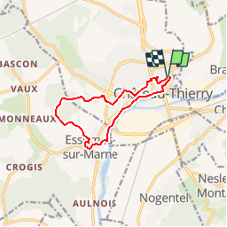
Trail Walking of 9.9 km to be discovered at Hauts-de-France, Aisne, Château-Thierry. This trail is proposed by tracegps.

Description

Un site stratégique qui fut constamment fortifié, Château-Thierry, un monument perpétuant le souvenir de l'engagement américain, le mémorial de la cote 204, et l'un des plus beaux monuments gothiques de la région, l'abbatiale d'Essômes, forment le décor de ce circuit qui se déroule le long de la Marne. Toutes les infos sont ICI

Elevation profile

Photos

Positioning

Country:
France
Region :
Hauts-de-France
Department/Province :
Aisne
Municipality :
Château-Thierry
Location:
Unknown
Start:(UTM)
529587 ; 5432823 (31U) N.

Trails nearby

Trail Running Verdilly - Verdilly Balcons de la Marne  - Photo
Running
nicochproun

Running

Medium
(1)
Verdilly, Hauts-de-France, Aisne, France
32 km | 41 km-effort
Unknown
Yes
Trail Walking Nesles-la-Montagne - Nesles la Montagne du 02/06/2020 - Photo
Walking
VANDERPUTTENMi

Walking

Very easy
Nesles-la-Montagne, Hauts-de-France, Aisne, France
8.6 km | 11.1 km-effort
1h 45min
Yes
Trail Mountain bike Château-Thierry - Château / Mont St Père / Azy / Château - Photo
Mountain bike
VANDERPUTTENMi

Mountain bike

Very easy
Château-Thierry, Hauts-de-France, Aisne, France
33 km | 35 km-effort
1h 40min
Yes
Trail Walking Château-Thierry - Château - Aulnois - Château du 26/05/2020 - Photo
Walking
VANDERPUTTENMi

Walking

Very easy
Château-Thierry, Hauts-de-France, Aisne, France
9.2 km | 11.1 km-effort
2h 4min
Yes
Trail Walking Château-Thierry - La cote 204 - Photo
Walking

Walking

Very easy
Château-Thierry, Hauts-de-France, Aisne, France
9.9 km | 12.7 km-effort
Unknown
Yes
Trail Walking Château-Thierry - Les vignes Castelles - version 2 - Photo
Walking
VANDERPUTTENMi

Walking

Medium
Château-Thierry, Hauts-de-France, Aisne, France
8.2 km | 10.3 km-effort
2h 20min
Yes
Trail Walking Château-Thierry - Parcours Art-Urbain - Jean de La Fontaine - Photo
Walking
VANDERPUTTENMi

Walking

Medium
Château-Thierry, Hauts-de-France, Aisne, France
9.1 km | 10.3 km-effort
2h 2min
Yes
Trail Walking Château-Thierry - Château-Thierry ADR par Essômes sur Marne - Photo
Walking
VANDERPUTTENMi

Walking

Medium
Château-Thierry, Hauts-de-France, Aisne, France
7.9 km | 9.5 km-effort
1h 55min
Yes
Trail Walking Château-Thierry - D'une rive à l'autre par Azy - Photo
Walking
VANDERPUTTENMi

Walking

Difficult
Château-Thierry, Hauts-de-France, Aisne, France
12.1 km | 14.1 km-effort
2h 45min
Yes


Close
My subscriptions