Trail Walking Chézy-sur-Marne - Les grenadiers de la Garde - Photo

Les grenadiers de la Garde

 tracegps
tracegps

User

© OpenStreetMap contributors
Length
Length
14.8 km
Max alt
Max alt
206 m
Uphill gradient
Uphill gradient
300 m
Km-Effort
Km-Effort  
18.8 km
Min alt
Min alt
63 m
Downhill gradient
Downhill gradient
300 m
Boucle
Boucle
Yes
Creation date :
2014-12-10 00:00:00.0
Updated on :
2014-12-10 00:00:00.0

(1 Reviews)

Walking
Walking
4h30
Difficulty : Very difficult

Scan this QR Code to open this trail in the SityTrail application

FREE GPS app for hiking

Logo SityTrail SityTrail

IGN / Geographical institutes

Download SityTrail from the App Store Download SityTrail from Google Play

Logo SityTrail SityTrail World

The world is yours!

Download SityTrail from the App Store Download SityTrail from Google Play Download SityTrail on Huawei AppGallery

About

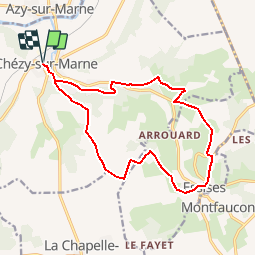
Trail Walking of 14.8 km to be discovered at Hauts-de-France, Aisne, Chézy-sur-Marne. This trail is proposed by tracegps.

Description

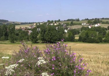
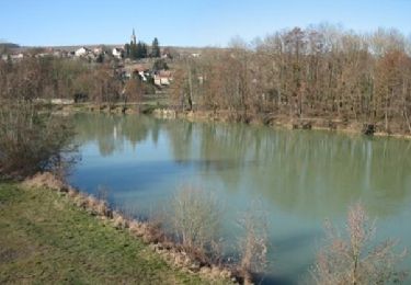
C'est en souvenir d'une bataille remportée par Napoléon 1er au hameau des Caquerets que ce circuit a été baptisé ainsi. Il remonte la vallée du Dolloir entre Chézy et Essises, où un petit musée rassemble les souvenirs de la campagne de France. Toutes les infos sont ICI

Elevation profile

Photos

Positioning

Country:
France
Region :
Hauts-de-France
Department/Province :
Aisne
Municipality :
Chézy-sur-Marne
Location:
Unknown
Start:(UTM)
526685 ; 5426355 (31U) N.

Comments

Please log in to post a review or rate the element


Trails nearby

Trail Walking Montfaucon - La croix de Montfaucon - Photo
Walking
tracegps

Walking

Very difficult
(1)
Montfaucon, Hauts-de-France, Aisne, France
14.7 km | 17.8 km-effort
3h 45min
Yes
Trail On foot Chézy-sur-Marne - CHEZY / MARNE VERSION 21 KM FINAL - Photo
On foot
explorateur

On foot

Medium
(1)
Chézy-sur-Marne, Hauts-de-France, Aisne, France
21 km | 27 km-effort
6h 2min
Yes
Trail Walking Azy-sur-Marne - BONNEIL - Photo
Walking
explorateur

Walking

Medium
(1)
Azy-sur-Marne, Hauts-de-France, Aisne, France
8.7 km | 10.8 km-effort
2h 21min
Yes
Trail Walking Nesles-la-Montagne - Nesles la Montagne du 02/06/2020 - Photo
Walking
VANDERPUTTENMi

Walking

Very easy
Nesles-la-Montagne, Hauts-de-France, Aisne, France
8.6 km | 11.1 km-effort
1h 45min
Yes
Trail Walking Azy-sur-Marne - La corniche d'Azy - Photo
Walking

Walking

Very easy
Azy-sur-Marne, Hauts-de-France, Aisne, France
10.6 km | 14.2 km-effort
Unknown
Yes
Trail Walking Nogent-l'Artaud - Nogent Alzheimer  - Photo
Walking
VANDERPUTTENMi

Walking

Very easy
Nogent-l'Artaud, Hauts-de-France, Aisne, France
15.7 km | 18.8 km-effort
3h 52min
Yes
Trail Mountain bike Nogent-l'Artaud - Le Mont-de-Bonneil - Photo
Mountain bike
tracegps

Mountain bike

Very difficult
Nogent-l'Artaud, Hauts-de-France, Aisne, France
26 km | 32 km-effort
4h 30min
Yes
Trail Walking Azy-sur-Marne - La corniche d'Azy - Photo
Walking
tracegps

Walking

Very difficult
Azy-sur-Marne, Hauts-de-France, Aisne, France
10.6 km | 14.2 km-effort
3h 30min
Yes
Trail Mountain bike Azy-sur-Marne - Les Bords de Marne en VTT - de Chézy sur Marne à Dormans - Photo
Mountain bike
tracegps

Mountain bike

Medium
Azy-sur-Marne, Hauts-de-France, Aisne, France
32 km | 36 km-effort
2h 30min
No


Close
My subscriptions