Trail Walking Merlieux-et-Fouquerolles - Les arts et les lettres - Photo
 tracegps
tracegps

User

© OpenStreetMap contributors
Length
Length
14.4 km
Max alt
Max alt
191 m
Uphill gradient
Uphill gradient
236 m
Km-Effort
Km-Effort  
17.5 km
Min alt
Min alt
83 m
Downhill gradient
Downhill gradient
236 m
Boucle
Boucle
Yes
Creation date :
2014-12-10 00:00:00.0
Updated on :
2014-12-10 00:00:00.0

(0 Reviews)

Walking
Walking
4h00
Difficulty : Very difficult

Scan this QR Code to open this trail in the SityTrail application

FREE GPS app for hiking

Logo SityTrail SityTrail

IGN / Geographical institutes

Download SityTrail from the App Store Download SityTrail from Google Play

Logo SityTrail SityTrail World

The world is yours!

Download SityTrail from the App Store Download SityTrail from Google Play Download SityTrail on Huawei AppGallery

About

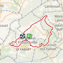
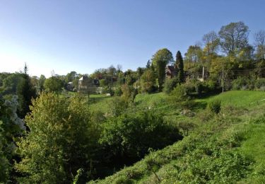
Trail Walking of 14.4 km to be discovered at Hauts-de-France, Aisne, Merlieux-et-Fouquerolles. This trail is proposed by tracegps.

Description

De Bourguignon (connu pour sa fête de l'art), à Merlieux (fête du livre), cette balade bucolique résume admirablement le patrimoine laonnois : les vendangeoirs et la maison natale des frères Le Nain, le château de Chailvet paré d'une façade à l'italienne et les lavoirs qui enjolivent le circuit. Toutes les infos sont ICI

Elevation profile

Photos

Positioning

Country:
France
Region :
Hauts-de-France
Department/Province :
Aisne
Municipality :
Merlieux-et-Fouquerolles
Location:
Unknown
Start:(UTM)
536453 ; 5484978 (31U) N.

Trails nearby

Trail Walking Mons-en-Laonnois - Autour du Fort de Laniscourt - Photo
Walking
tracegps

Walking

Easy
(1)
Mons-en-Laonnois, Hauts-de-France, Aisne, France
5.3 km | 6.2 km-effort
1h 30min
Yes
Trail Walking Chavignon - Chavignon - Du Pont Noir au Bélier - Photo
Walking
tracegps

Walking

Difficult
(1)
Chavignon, Hauts-de-France, Aisne, France
14.5 km | 17.2 km-effort
3h 45min
Yes
Trail Walking Cessières-Suzy - randonnée à  Cessieres 02 - Photo
Walking
José800

Walking

Medium
Cessières-Suzy, Hauts-de-France, Aisne, France
12.4 km | 15.3 km-effort
2h 56min
Yes
Trail Walking Mons-en-Laonnois - Circuit 10.6 km Détours dans la butte de Mons - Photo
Walking
Jojo-02

Walking

Very easy
Mons-en-Laonnois, Hauts-de-France, Aisne, France
10.6 km | 13.7 km-effort
2h 56min
Yes
Trail Walking Mons-en-Laonnois - Détours dans la butte de Mons - Photo
Walking

Walking

Very easy
(1)
Mons-en-Laonnois, Hauts-de-France, Aisne, France
10.6 km | 13.7 km-effort
Unknown
Yes
Trail Mountain bike Mons-en-Laonnois - Buttes et marais - Photo
Mountain bike
tracegps

Mountain bike

Very difficult
Mons-en-Laonnois, Hauts-de-France, Aisne, France
28 km | 36 km-effort
4h 0min
Yes
Trail Walking Anizy-le-Grand - Les Larris - Photo
Walking
tracegps

Walking

Very difficult
Anizy-le-Grand, Hauts-de-France, Aisne, France
14.4 km | 18.2 km-effort
4h 0min
Yes
Trail Walking Cessières-Suzy - Le rendez-vous en forêt - Photo
Walking
tracegps

Walking

Medium
Cessières-Suzy, Hauts-de-France, Aisne, France
11.6 km | 15.6 km-effort
3h 30min
Yes
Trail Walking Cessières-Suzy - A la recherche de la Drosera - Photo
Walking
tracegps

Walking

Very difficult
Cessières-Suzy, Hauts-de-France, Aisne, France
17.6 km | 22 km-effort
4h 40min
Yes


Close
My subscriptions