Trail Walking Cuffies - La pierre à sel - Photo

La pierre à sel

 tracegps
tracegps

User

© OpenStreetMap contributors
Length
Length
18.3 km
Max alt
Max alt
153 m
Uphill gradient
Uphill gradient
298 m
Km-Effort
Km-Effort  
22 km
Min alt
Min alt
54 m
Downhill gradient
Downhill gradient
299 m
Boucle
Boucle
Yes
Creation date :
2014-12-10 00:00:00.0
Updated on :
2014-12-10 00:00:00.0

(0 Reviews)

Walking
Walking
6h00
Difficulty : Unknown

Scan this QR Code to open this trail in the SityTrail application

FREE GPS app for hiking

Logo SityTrail SityTrail

IGN / Geographical institutes

Download SityTrail from the App Store Download SityTrail from Google Play

Logo SityTrail SityTrail World

The world is yours!

Download SityTrail from the App Store Download SityTrail from Google Play Download SityTrail on Huawei AppGallery

About

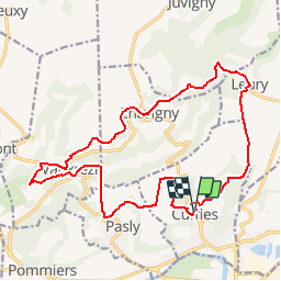
Trail Walking of 18.3 km to be discovered at Hauts-de-France, Aisne, Cuffies. This trail is proposed by tracegps.

Description

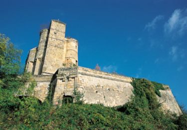
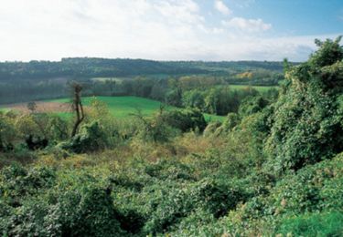
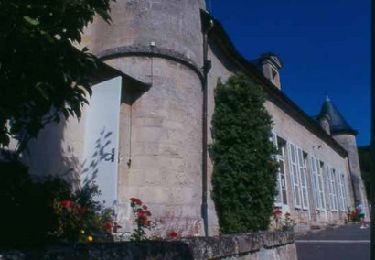
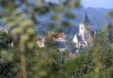
Passé le ru de Juvigny, le circuit rejoint la pierre à sel sur la place de Chavigny puis, à travers le marais, les vestiges de l'oppidum de Noviodunum (point de ralliement des Suessions), dont César ne put s'emparer en 57 av. J.-C. Toutes les infos sont ICI

Elevation profile

Photos

Positioning

Country:
France
Region :
Hauts-de-France
Department/Province :
Aisne
Municipality :
Cuffies
Location:
Unknown
Start:(UTM)
523202 ; 5472579 (31U) N.

Trails nearby

Trail Walking Clamecy - GR 12 de Clamecy à Sancy les Cheminots - Photo
Walking
VANDERPUTTENMi

Walking

Very easy
Clamecy, Hauts-de-France, Aisne, France
19.5 km | 25 km-effort
6h 19min
No
Trail Cycle Soissons - Sortir de la Crise ! - Soissons - Photo
Cycle
tracegps

Cycle

Medium
Soissons, Hauts-de-France, Aisne, France
58 km | 67 km-effort
3h 0min
Yes
Trail Walking Soissons - Flâneries Soissonnaises - Photo
Walking

Walking

Very easy
Soissons, Hauts-de-France, Aisne, France
2.4 km | 2.7 km-effort
Unknown
Yes
Trail Mountain bike Mercin-et-Vaux - Circuit Clovis - Photo
Mountain bike
tracegps

Mountain bike

Very difficult
Mercin-et-Vaux, Hauts-de-France, Aisne, France
24 km | 29 km-effort
3h 30min
Yes
Trail Mountain bike Pommiers - Le ru de Juvigny - Photo
Mountain bike
tracegps

Mountain bike

Medium
Pommiers, Hauts-de-France, Aisne, France
22 km | 25 km-effort
2h 30min
Yes
Trail Walking Soissons - Les Monts - Photo
Walking
tracegps

Walking

Very easy
Soissons, Hauts-de-France, Aisne, France
18.9 km | 22 km-effort
6h 30min
Yes
Trail Walking Mercin-et-Vaux - Les chemins des hauts champs - Photo
Walking
tracegps

Walking

Medium
Mercin-et-Vaux, Hauts-de-France, Aisne, France
9.3 km | 11.8 km-effort
2h 0min
Yes
Trail Walking Terny-Sorny - Autour de Montgarny - Photo
Walking
tracegps

Walking

Medium
Terny-Sorny, Hauts-de-France, Aisne, France
8.9 km | 11.1 km-effort
2h 45min
Yes
Trail Electric bike Soissons - Hervé Soissonais  - Photo
Electric bike
Herve Hermant

Electric bike

Medium
Soissons, Hauts-de-France, Aisne, France
62 km | 73 km-effort
4h 30min
Yes


Close
My subscriptions