Trail Walking Bucy-le-Long - Détours et des tours - Photo

Détours et des tours

 tracegps
tracegps

User

© OpenStreetMap contributors
Length
Length
7 km
Max alt
Max alt
138 m
Uphill gradient
Uphill gradient
146 m
Km-Effort
Km-Effort  
9 km
Min alt
Min alt
50 m
Downhill gradient
Downhill gradient
148 m
Boucle
Boucle
Yes
Creation date :
2014-12-10 00:00:00.0
Updated on :
2014-12-10 00:00:00.0

(0 Reviews)

Walking
Walking
1h45
Difficulty : Medium

Scan this QR Code to open this trail in the SityTrail application

FREE GPS app for hiking

Logo SityTrail SityTrail

IGN / Geographical institutes

Download SityTrail from the App Store Download SityTrail from Google Play

Logo SityTrail SityTrail World

The world is yours!

Download SityTrail from the App Store Download SityTrail from Google Play Download SityTrail on Huawei AppGallery

About

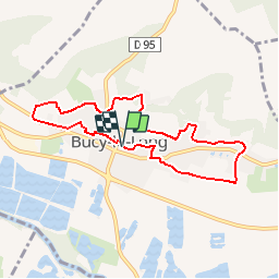
Trail Walking of 7 km to be discovered at Hauts-de-France, Aisne, Bucy-le-Long. This trail is proposed by tracegps.

Description

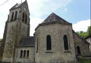
Ce circuit part à la découverte du ravissant village de Bucy-le-Long : il emprunte sentes, ruelles et sentiers, longe lavoirs, églises et châteaux entre colombiers et maisons à pas-de-moineaux. Toutes les infos sont ICI

Elevation profile

Photos

Positioning

Country:
France
Region :
Hauts-de-France
Department/Province :
Aisne
Municipality :
Bucy-le-Long
Location:
Unknown
Start:(UTM)
528683 ; 5470982 (31U) N.

Trails nearby

Trail Walking Venizel - Les rives de la vallée - Photo
Walking
tracegps

Walking

Medium
(1)
Venizel, Hauts-de-France, Aisne, France
10.8 km | 12 km-effort
2h 45min
Yes
Trail Walking Chivres-Val - Fort de condé - chivres - Photo
Walking
fitz2014

Walking

Very difficult
(1)
Chivres-Val, Hauts-de-France, Aisne, France
18 km | 22 km-effort
4h 48min
Yes
Trail Walking Clamecy - GR 12 de Clamecy à Sancy les Cheminots - Photo
Walking
VANDERPUTTENMi

Walking

Very easy
Clamecy, Hauts-de-France, Aisne, France
19.5 km | 25 km-effort
6h 19min
No
Trail Cycle Soissons - Sortir de la Crise ! - Soissons - Photo
Cycle
tracegps

Cycle

Medium
Soissons, Hauts-de-France, Aisne, France
58 km | 67 km-effort
3h 0min
Yes
Trail Walking Chivres-Val - 11 la fontaine St ouen - Photo
Walking
fitz2014

Walking

Medium
Chivres-Val, Hauts-de-France, Aisne, France
14.1 km | 17.5 km-effort
3h 53min
Yes
Trail Walking Chivres-Val - Autour du fort de Condé - Photo
Walking

Walking

Very easy
Chivres-Val, Hauts-de-France, Aisne, France
939 m | 999 m-effort
Unknown
Yes
Trail Walking Soissons - Flâneries Soissonnaises - Photo
Walking

Walking

Very easy
Soissons, Hauts-de-France, Aisne, France
2.4 km | 2.7 km-effort
Unknown
Yes
Trail Walking Bucy-le-Long - Détours et des tours - Photo
Walking

Walking

Very easy
Bucy-le-Long, Hauts-de-France, Aisne, France
7 km | 9 km-effort
Unknown
Yes
Trail Walking Chivres-Val - Chivres Val - La Fontaine de St Ouen - Photo
Walking
tracegps

Walking

Medium
Chivres-Val, Hauts-de-France, Aisne, France
12 km | 15.1 km-effort
4h 0min
No


Close
My subscriptions