Trail Walking Puiseux-en-Retz - Le ru de Retz - Photo
 tracegps
tracegps

User

© OpenStreetMap contributors
Length
Length
9.1 km
Max alt
Max alt
234 m
Uphill gradient
Uphill gradient
212 m
Km-Effort
Km-Effort  
11.9 km
Min alt
Min alt
80 m
Downhill gradient
Downhill gradient
214 m
Boucle
Boucle
Yes
Creation date :
2014-12-10 00:00:00.0
Updated on :
2014-12-10 00:00:00.0

(0 Reviews)

Walking
Walking
2h30
Difficulty : Very difficult

Scan this QR Code to open this trail in the SityTrail application

FREE GPS app for hiking

Logo SityTrail SityTrail

IGN / Geographical institutes

Download SityTrail from the App Store Download SityTrail from Google Play

Logo SityTrail SityTrail World

The world is yours!

Download SityTrail from the App Store Download SityTrail from Google Play Download SityTrail on Huawei AppGallery

About

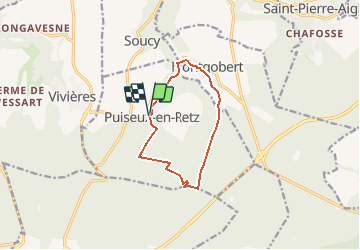
Trail Walking of 9.1 km to be discovered at Hauts-de-France, Aisne, Puiseux-en-Retz. This trail is proposed by tracegps.

Description

Depuis le village fleuri de Puisieux, de pinède en hêtraie et en peupleraie, ce circuit entre forêts et vallons mène au monument Mangin, hommage à la contre-offensive décisive de 1918, puis à Montgobert, où le musée du Bois présente dans le château une impressionnante collection d'outils agricoles et forestiers. Toutes les infos sont ICI

Elevation profile

Photos

Positioning

Country:
France
Region :
Hauts-de-France
Department/Province :
Aisne
Municipality :
Puiseux-en-Retz
Location:
Unknown
Start:(UTM)
509418 ; 5460445 (31U) N.

Trails nearby

Trail Walking Corcy - FLEURY .AISNE  - Photo
Walking
TURLUPIN2010

Walking

Medium
Corcy, Hauts-de-France, Aisne, France
5.7 km | 7.9 km-effort
1h 25min
Yes
Trail Walking Fleury - en Forêt de Retz_92_05_2022_Rond d'Orléans_Chapeau des Cordeliers_la Laie des étangs de Longpont - Photo
Walking

Walking

Medium
Fleury, Hauts-de-France, Aisne, France
9.2 km | 10.9 km-effort
2h 46min
Yes
Trail Walking Corcy - en forêt de Retz_91_04_2022_la Laie de la Belle Epine - Photo
Walking

Walking

Difficult
Corcy, Hauts-de-France, Aisne, France
10.6 km | 13.3 km-effort
3h 32min
Yes
Trail On foot Puiseux-en-Retz - Route du Faîte - Photo
On foot
PRO

On foot

Easy
Puiseux-en-Retz, Hauts-de-France, Aisne, France
5.8 km | 7.1 km-effort
1h 37min
No
Trail Walking Largny-sur-Automne - en Forêt de Retz_90_09_2021_la Selve - Photo
Walking

Walking

Medium
Largny-sur-Automne, Hauts-de-France, Aisne, France
6.2 km | 7.8 km-effort
1h 52min
Yes
Trail Walking Villers-Cotterêts - en Forêt de Retz_89_09_2021_les Ventes Racines et le Chablis des Bouleaux - Photo
Walking

Walking

Medium
Villers-Cotterêts, Hauts-de-France, Aisne, France
10.2 km | 12.1 km-effort
3h 14min
Yes
Trail Walking Villers-Cotterêts - Domaine de Coyolles - Photo
Walking
TURLUPIN2010

Walking

Medium
Villers-Cotterêts, Hauts-de-France, Aisne, France
14.3 km | 16.3 km-effort
3h 0min
Yes
Trail Walking Vivières - en Forêt de Retz_88_autour du Regard Saint-Hubert et du Rond de la Reine - Photo
Walking

Walking

Very difficult
Vivières, Hauts-de-France, Aisne, France
12.3 km | 15.5 km-effort
4h 36min
Yes
Trail Walking Montgobert - en forêt de Retz_83_les Champs Mentard_le Fond d'Argent - Photo
Walking

Walking

Medium
Montgobert, Hauts-de-France, Aisne, France
13.6 km | 16.2 km-effort
3h 46min
Yes


Close
My subscriptions