Trail Walking Crécy-sur-Serre - La tour de Crécy - variante - Photo

La tour de Crécy - variante

 tracegps
tracegps

User

© OpenStreetMap contributors
Length
Length
15.6 km
Max alt
Max alt
137 m
Uphill gradient
Uphill gradient
157 m
Km-Effort
Km-Effort  
17.7 km
Min alt
Min alt
54 m
Downhill gradient
Downhill gradient
157 m
Boucle
Boucle
Yes
Creation date :
2014-12-10 00:00:00.0
Updated on :
2014-12-10 00:00:00.0

(0 Reviews)

Walking
Walking
4h30
Difficulty : Very difficult

Scan this QR Code to open this trail in the SityTrail application

FREE GPS app for hiking

Logo SityTrail SityTrail

IGN / Geographical institutes

Download SityTrail from the App Store Download SityTrail from Google Play

Logo SityTrail SityTrail World

The world is yours!

Download SityTrail from the App Store Download SityTrail from Google Play Download SityTrail on Huawei AppGallery

About

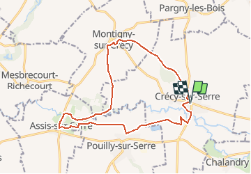
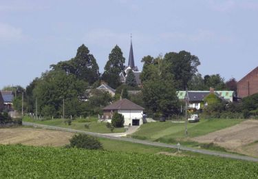
Trail Walking of 15.6 km to be discovered at Hauts-de-France, Aisne, Crécy-sur-Serre. This trail is proposed by tracegps.

Description

Ponctuée par un calvaire, par un moulin sur la Serre et par l'imposant beffroi dit aussi "tour de Crécy", cette intéressante balade évoque la campagne laonnoise, alternant bois, chemin de terre, route goudronnée, rivière et voie ferrée. Détruit pendant la guerre de 1914-18, le village d'Assis s'est reconstruit autour de son église Saint-Martin, d'origine romane, rebâtie une première fois à l'époque gothique, puis au cours du XVIe siècle. Toutes les infos sont ICI

Elevation profile

Positioning

Country:
France
Region :
Hauts-de-France
Department/Province :
Aisne
Municipality :
Crécy-sur-Serre
Location:
Unknown
Start:(UTM)
544952 ; 5505045 (31U) N.

Trails nearby

Trail Mountain bike Assis-sur-Serre - La Butte des Templiers - Photo
Mountain bike
tracegps

Mountain bike

Medium
Assis-sur-Serre, Hauts-de-France, Aisne, France
20 km | 22 km-effort
3h 0min
Yes
Trail Walking Montigny-sur-Crécy - Les méandres de la Serre - Photo
Walking
tracegps

Walking

Medium
Montigny-sur-Crécy, Hauts-de-France, Aisne, France
11.7 km | 13.8 km-effort
3h 15min
Yes
Trail Walking Bois-lès-Pargny - La forêt de Marle - Photo
Walking
tracegps

Walking

Medium
Bois-lès-Pargny, Hauts-de-France, Aisne, France
9.8 km | 12.1 km-effort
3h 0min
Yes
Trail Walking Crécy-sur-Serre - La tour de Crécy - Photo
Walking
tracegps

Walking

Very difficult
Crécy-sur-Serre, Hauts-de-France, Aisne, France
14.6 km | 16.7 km-effort
3h 45min
Yes
Trail Mountain bike Assis-sur-Serre - La butte des Templiers - Photo
Mountain bike
tracegps

Mountain bike

Difficult
Assis-sur-Serre, Hauts-de-France, Aisne, France
20 km | 23 km-effort
2h 30min
Yes
Trail Mountain bike Assis-sur-Serre - La Butte des Templiers - Photo
Mountain bike
tracegps

Mountain bike

Medium
Assis-sur-Serre, Hauts-de-France, Aisne, France
23 km | 26 km-effort
3h 30min
Yes
Trail Walking Pouilly-sur-Serre - 10 12 - Photo
Walking
Claudie Normand

Walking

Easy
Pouilly-sur-Serre, Hauts-de-France, Aisne, France
3.7 km | 4 km-effort
1h 2min
No


Close
My subscriptions