


Le grand Arbois

soca
User
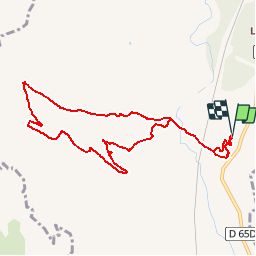

Length
9.6 km

Max alt
245 m

Uphill gradient
192 m
Km-Effort
12.2 km

Min alt
126 m

Downhill gradient
192 m
Boucle
Yes
Creation date :
2019-01-15 20:10:54.773
Updated on :
2019-01-15 20:10:54.773
2h37
Difficulty : Easy

FREE GPS app for hiking
 SityTrail
IGN / Geographical institutes
SityTrail Plus
The world is yours!
About
Trail Walking of 9.6 km to be discovered at Provence-Alpes-Côte d'Azur, Bouches-du-Rhône, Aix-en-Provence. This trail is proposed by soca.
Positioning
Country:
France
Region :
Provence-Alpes-Côte d'Azur
Department/Province :
Bouches-du-Rhône
Municipality :
Aix-en-Provence
Location:
Unknown
Start:(Dec)
Start:(UTM)
687347 ; 4817722 (31T) N.
Comments