Trail Walking Murbach - Le Grand Ballon par Murbach - Photo

Le Grand Ballon par Murbach

 tracegps
tracegps

User

© OpenStreetMap contributors
Length
Length
20 km
Max alt
Max alt
1404 m
Uphill gradient
Uphill gradient
1213 m
Km-Effort
Km-Effort  
37 km
Min alt
Min alt
437 m
Downhill gradient
Downhill gradient
1228 m
Boucle
Boucle
Yes
Creation date :
2014-12-10 00:00:00.0
Updated on :
2014-12-10 00:00:00.0

(2 Reviews)

Walking
Walking
6h30
Difficulty : Difficult

Scan this QR Code to open this trail in the SityTrail application

FREE GPS app for hiking

Logo SityTrail SityTrail

IGN / Geographical institutes

Download SityTrail from the App Store Download SityTrail from Google Play

Logo SityTrail SityTrail World

The world is yours!

Download SityTrail from the App Store Download SityTrail from Google Play Download SityTrail on Huawei AppGallery

About

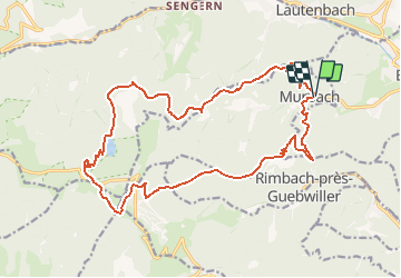
Trail Walking of 20 km to be discovered at Grand Est, Haut-Rhin, Murbach. This trail is proposed by tracegps.

Description

Le Grand Ballon par Murbach. Randonnée en boucle au départ de Murbach. Celle-ci permet de gravir le plus haut sommet des Vosges qui offre une vue magnifique sur les vallées alentour, tout en offrant une halte rafraichissante sur les berges du lac du Ballon. Découvrez la suite sur le site de la Communauté des Crapahuteurs.

Elevation profile

Photos

Positioning

Country:
France
Region :
Grand Est
Department/Province :
Haut-Rhin
Municipality :
Murbach
Location:
Unknown
Start:(UTM)
362483 ; 5309417 (32T) N.

Comments

Please log in to post a review or rate the element


Tres sympa


Trails nearby

Trail Walking Linthal - Tour de la grande Vallée de Munster (refuge du Hilsen - Munster) - Photo
Walking
tracegps

Walking

Difficult
(1)
Linthal, Grand Est, Haut-Rhin, France
18.1 km | 24 km-effort
5h 0min
No
Trail Walking Lautenbachzell - Le Markstein - Photo
Walking
tracegps

Walking

Difficult
(1)
Lautenbachzell, Grand Est, Haut-Rhin, France
22 km | 35 km-effort
6h 0min
Yes
Trail On foot Goldbach-Altenbach - Firstacker - Willer sur Thur - Photo
On foot
PRO

On foot

Easy
Goldbach-Altenbach, Grand Est, Haut-Rhin, France
7.4 km | 9.6 km-effort
2h 11min
No
Trail Walking Linthal - SityTrail - Remspach-Hilsen - Photo
Walking

Walking

Medium
(1)
Linthal, Grand Est, Haut-Rhin, France
9.9 km | 14.6 km-effort
3h 3min
Yes
Trail Walking Soultz-Haut-Rhin - Rando Marcheurs..04/04_2025 - Photo
Walking
boubou68

Walking

Very difficult
Soultz-Haut-Rhin, Grand Est, Haut-Rhin, France
21 km | 35 km-effort
4h 42min
Yes
Trail Walking Jungholtz - Rando Retrouvailles...01/03/2024.par Jean Marc - Photo
Walking
boubou68

Walking

Very difficult
Jungholtz, Grand Est, Haut-Rhin, France
11.3 km | 19.2 km-effort
1h 35min
Yes
Trail Walking Soultz-Haut-Rhin - Mon tour des Vosges (4 jours) - Photo
Walking
annefrance70

Walking

Very difficult
Soultz-Haut-Rhin, Grand Est, Haut-Rhin, France
71 km | 113 km-effort
25h 38min
Yes
Trail Walking Murbach - La
Walking
boubou68

Walking

Very difficult
Murbach, Grand Est, Haut-Rhin, France
14.7 km | 28 km-effort
4h 3min
Yes
Trail Walking Murbach - Murbach - Photo
Walking
oscar1

Walking

Difficult
Murbach, Grand Est, Haut-Rhin, France
15.4 km | 25 km-effort
4h 25min
Yes


Close
My subscriptions