Trail Walking Englefontaine - Circuit du Saint - Georges à Mormal - Englefontaine - Photo

Circuit du Saint - Georges à Mormal - Englefontaine

 tracegps
tracegps

User

© OpenStreetMap contributors
Length
Length
11.6 km
Max alt
Max alt
176 m
Uphill gradient
Uphill gradient
110 m
Km-Effort
Km-Effort  
13.1 km
Min alt
Min alt
137 m
Downhill gradient
Downhill gradient
111 m
Boucle
Boucle
Yes
Creation date :
2014-12-10 00:00:00.0
Updated on :
2014-12-10 00:00:00.0

(1 Reviews)

Walking
Walking
3h00
Difficulty : Medium

Scan this QR Code to open this trail in the SityTrail application

FREE GPS app for hiking

Logo SityTrail SityTrail

IGN / Geographical institutes

Download SityTrail from the App Store Download SityTrail from Google Play

Logo SityTrail SityTrail World

The world is yours!

Download SityTrail from the App Store Download SityTrail from Google Play Download SityTrail on Huawei AppGallery

About

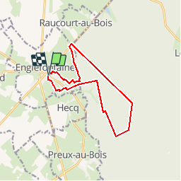
Trail Walking of 11.6 km to be discovered at Hauts-de-France, Nord, Englefontaine. This trail is proposed by tracegps.

Description

Circuit proposé par le Comité Départemental du Tourisme du Nord. Départ de la Place d’Englefontaine, prés de l’église. Entre lisière et forêt, ce permet de découvrir des "caches" bocagères, des chemins et des sentiers forestiers. Retrouvez cette randonnée sur le site du Comité Départemental du Tourisme du Nord.

Elevation profile

Photos

Positioning

Country:
France
Region :
Hauts-de-France
Department/Province :
Nord
Municipality :
Englefontaine
Location:
Unknown
Start:(UTM)
545937 ; 5560060 (31U) N.

Comments

Please log in to post a review or rate the element


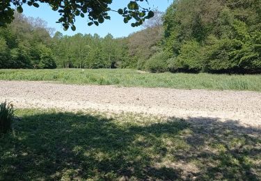
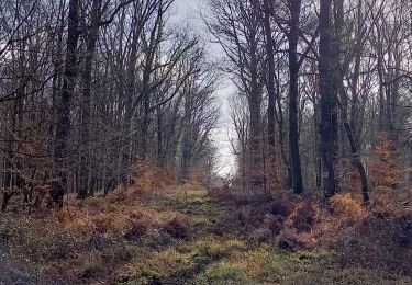
Circuit très calme et appréciable en pleine forêt


Trails nearby

Trail Walking Englefontaine - Englefontaine. Lisière Mormal  - Photo
Walking
ayumi atsu

Walking

Medium
Englefontaine, Hauts-de-France, Nord, France
7.5 km | 8.5 km-effort
1h 22min
Yes
Trail Walking Preux-au-Bois - Circuit de Preux au Bois - Photo
Walking
terminio

Walking

Easy
(1)
Preux-au-Bois, Hauts-de-France, Nord, France
11.3 km | 12.8 km-effort
2h 49min
Yes
Trail Walking Locquignol - pâture d'Haisne www.foretdemormal.fr - Photo
Walking
jfhogne

Walking

Very easy
Locquignol, Hauts-de-France, Nord, France
6.1 km | 7 km-effort
1h 38min
No
Trail Walking Bousies - Circuit « Perds-tes-Peines » (Bousies) - Photo
Walking
tracegps

Walking

Easy
Bousies, Hauts-de-France, Nord, France
3.7 km | 4.1 km-effort
1h 0min
Yes
Trail Walking Preux-au-Bois - Circuit de Preux - au - Bois - Photo
Walking
tracegps

Walking

Easy
(1)
Preux-au-Bois, Hauts-de-France, Nord, France
10.3 km | 11.8 km-effort
2h 40min
Yes
Trail Nordic walking Potelle - Pont à vaches. Locquignol. Retour  - Photo
Nordic walking
ayumi atsu

Nordic walking

Easy
(1)
Potelle, Hauts-de-France, Nord, France
6.2 km | 7.1 km-effort
1h 15min
Yes
Trail Walking Louvignies-Quesnoy - Ecaillon - Photo
Walking
Greg813

Walking

Medium
Louvignies-Quesnoy, Hauts-de-France, Nord, France
11.9 km | 13.3 km-effort
2h 28min
Yes
Trail Walking Louvignies-Quesnoy - Circuit de l'Ecaillon - (Louvignies-Quesnoy) - Photo
Walking
tracegps

Walking

Medium
Louvignies-Quesnoy, Hauts-de-France, Nord, France
11.5 km | 13 km-effort
2h 49min
Yes
Trail Walking Salesches - Circuits des fleurs champêtres (Salesches) - Photo
Walking
tracegps

Walking

Difficult
(1)
Salesches, Hauts-de-France, Nord, France
13.2 km | 14.8 km-effort
3h 19min
Yes


Close
My subscriptions