Trail Walking Gambais - De Gambais à Condé sur Vesgre - Photo

De Gambais à Condé sur Vesgre

 tracegps
tracegps

User

© OpenStreetMap contributors
Length
Length
23 km
Max alt
Max alt
192 m
Uphill gradient
Uphill gradient
255 m
Km-Effort
Km-Effort  
27 km
Min alt
Min alt
96 m
Downhill gradient
Downhill gradient
255 m
Boucle
Boucle
Yes
Creation date :
2014-12-10 00:00:00.0
Updated on :
2014-12-10 00:00:00.0

(0 Reviews)

Walking
Walking
4h30
Difficulty : Medium

Scan this QR Code to open this trail in the SityTrail application

FREE GPS app for hiking

Logo SityTrail SityTrail

IGN / Geographical institutes

Download SityTrail from the App Store Download SityTrail from Google Play

Logo SityTrail SityTrail World

The world is yours!

Download SityTrail from the App Store Download SityTrail from Google Play Download SityTrail on Huawei AppGallery

About

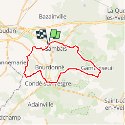
Trail Walking of 23 km to be discovered at Ile-de-France, Yvelines, Gambais. This trail is proposed by tracegps.

Description

Départ : Gambais, Chapelle Saint Agnan Cimetière. Caractéristiques : Le chemin autour de la Ferme Olivet est un chemin rural et non privé comme indiqué sur place. Descriptif : nb, Gambais, Ferme Olivet, Saint Côme … GRP, Bois de la Ferrière, Chaudejoute ... nb, La Cage à Margot, Ferme de l’Hermeray, Condé-sur-Vesgre, Poulampont, les Haies, la Roche du Curé (13), carrefour du Belvédère, Poteau des Quenouilles, Maison Forestière du Bocquet ... GR22, Gambaiseuil, carrefour des Bruyères de Neuville, Poteau de l’Etang Neuf, cote 110,8 ... nb, la Guérinoterie, Bois des Novales, Chapelle Saint Agnan. Des sentiers ont pu être modifiés depuis la dernière validation et les itinéraires proposés n’engagent pas la responsabilité du Comité. Signalez-nous les modifications rencontrées pour mise à jour de la randothèque.

Elevation profile

Photos

Positioning

Country:
France
Region :
Ile-de-France
Department/Province :
Yvelines
Municipality :
Gambais
Location:
Unknown
Start:(Dec)
Start:(UTM)
401784 ; 5403584 (31U) N.

Trails nearby

Trail Walking Houdan - HM 1 - Photo
Walking
THERMET

Walking

Houdan, Ile-de-France, Yvelines, France
15.1 km | 17.1 km-effort
1h 13min
No
Trail Equestrian Gambaiseuil - Rambouillet escarpée - Photo
Equestrian
tracegps

Equestrian

Difficult
(1)
Gambaiseuil, Ile-de-France, Yvelines, France
5.9 km | 7.8 km-effort
49min
Yes
Trail Electric bike Gambais - Tour de Houdan 1 - Photo
Electric bike
YVES M

Electric bike

Very easy
Gambais, Ile-de-France, Yvelines, France
36 km | 41 km-effort
3h 17min
Yes
Trail Hybrid bike Gambais - Gambais Rambouillet les haizettes Gambais - Photo
Hybrid bike
michmich

Hybrid bike

Medium
Gambais, Ile-de-France, Yvelines, France
61 km | 69 km-effort
6h 8min
Yes
Trail Other activity Maulette - de l'eure a la vesgre - Photo
Other activity
olivieraron

Other activity

Very easy
Maulette, Ile-de-France, Yvelines, France
102 km | 116 km-effort
2h 22min
Yes
Trail Walking Gambaiseuil - ADAL 20140916 GAMBAISEUIL - Photo
Walking
VVerley

Walking

Medium
Gambaiseuil, Ile-de-France, Yvelines, France
20 km | 24 km-effort
5h 9min
Yes
Trail Walking Bourdonné - Bourdonné*Gambais - Photo
Walking
raivavae

Walking

Easy
(1)
Bourdonné, Ile-de-France, Yvelines, France
12.8 km | 14.5 km-effort
5min
Yes
Trail Walking Gambaiseuil - Forêt de Gambais - Photo
Walking
michmich

Walking

Easy
Gambaiseuil, Ile-de-France, Yvelines, France
5.6 km | 7.1 km-effort
1h 9min
Yes
Trail Mountain bike Gambaiseuil - Bonnelles 22/03/22 - Photo
Mountain bike
sullecram

Mountain bike

Medium
Gambaiseuil, Ile-de-France, Yvelines, France
22 km | 25 km-effort
2h 59min
Yes


Close
My subscriptions