Trail Walking Fonches-Fonchette - Circuit de la source blanche - Fonches - Photo

Circuit de la source blanche - Fonches

 tracegps
tracegps

User

© OpenStreetMap contributors
Length
Length
8.4 km
Max alt
Max alt
84 m
Uphill gradient
Uphill gradient
57 m
Km-Effort
Km-Effort  
9.2 km
Min alt
Min alt
66 m
Downhill gradient
Downhill gradient
58 m
Boucle
Boucle
Yes
Creation date :
2014-12-10 00:00:00.0
Updated on :
2014-12-10 00:00:00.0

(0 Reviews)

Walking
Walking
2h10
Difficulty : Medium

Scan this QR Code to open this trail in the SityTrail application

FREE GPS app for hiking

Logo SityTrail SityTrail

IGN / Geographical institutes

Download SityTrail from the App Store Download SityTrail from Google Play

Logo SityTrail SityTrail World

The world is yours!

Download SityTrail from the App Store Download SityTrail from Google Play Download SityTrail on Huawei AppGallery

About

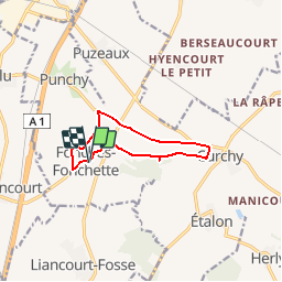
Trail Walking of 8.4 km to be discovered at Hauts-de-France, Somme, Fonches-Fonchette. This trail is proposed by tracegps.

Description

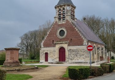
Circuit proposé par la Communauté de Communes du Pays Neslois Départ de Fonches-Fonchette. La source blanche est toujours en activité et fait partie du parcours. L’église Saint Médard (datée du XVIIème et XIXème s.) à Curchy est l’une des plus vieilles églises du Santerre. Elle a la particularité de posséder deux coqs sur le clocher. Enfin, vous aurez tout le loisir de contempler l’église Saint Vaast de Fonches-Fonchette reconstruite en 1918 et sa chapelle. Retrouvez cette randonnée sur le site de la Communauté de Communes du Pays Neslois.

Elevation profile

Photos

Positioning

Country:
France
Region :
Hauts-de-France
Department/Province :
Somme
Municipality :
Fonches-Fonchette
Location:
Unknown
Start:(UTM)
486860 ; 5513647 (31U) N.

Trails nearby

Trail Walking Maucourt - le village négre a maucout 80 - Photo
Walking
José800

Walking

Easy
Maucourt, Hauts-de-France, Somme, France
10.8 km | 11.4 km-effort
2h 32min
Yes
Trail Walking Curchy - Circuit de l'Ingon - Curchy - Photo
Walking
tracegps

Walking

Medium
Curchy, Hauts-de-France, Somme, France
9.7 km | 10.7 km-effort
2h 30min
Yes
Trail Walking Hypercourt - Circuit du bois de Meurdris -  Pertain - Photo
Walking
tracegps

Walking

Medium
Hypercourt, Hauts-de-France, Somme, France
12.9 km | 13.8 km-effort
3h 15min
Yes
Trail Walking Maucourt - Le village nègre à  Maucourt 80 - Photo
Walking
José800

Walking

Easy
Maucourt, Hauts-de-France, Somme, France
10.7 km | 11.3 km-effort
3h 13min
Yes
Trail Walking Rethonvillers - Jose 800 - Photo
Walking
José800

Walking

Medium
Rethonvillers, Hauts-de-France, Somme, France
11.3 km | 11.9 km-effort
2h 43min
Yes
Trail Walking Hypercourt - jose 800 - Photo
Walking
José800

Walking

Medium
Hypercourt, Hauts-de-France, Somme, France
9 km | 9.5 km-effort
2h 2min
Yes
Trail Walking Curchy - Curchy - Photo
Walking
jpblimond

Walking

Easy
Curchy, Hauts-de-France, Somme, France
17.7 km | 19.3 km-effort
4h 4min
Yes


Close
My subscriptions