Trail Walking Pargny - Circuit du Clos Bouteille -  Pargny - Photo

Circuit du Clos Bouteille - Pargny

 tracegps
tracegps

User

© OpenStreetMap contributors
Length
Length
10.7 km
Max alt
Max alt
61 m
Uphill gradient
Uphill gradient
64 m
Km-Effort
Km-Effort  
11.5 km
Min alt
Min alt
48 m
Downhill gradient
Downhill gradient
64 m
Boucle
Boucle
Yes
Creation date :
2014-12-10 00:00:00.0
Updated on :
2014-12-10 00:00:00.0

(0 Reviews)

Walking
Walking
2h00
Difficulty : Medium

Scan this QR Code to open this trail in the SityTrail application

FREE GPS app for hiking

Logo SityTrail SityTrail

IGN / Geographical institutes

Download SityTrail from the App Store Download SityTrail from Google Play

Logo SityTrail SityTrail World

The world is yours!

Download SityTrail from the App Store Download SityTrail from Google Play Download SityTrail on Huawei AppGallery

About

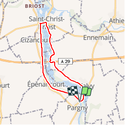
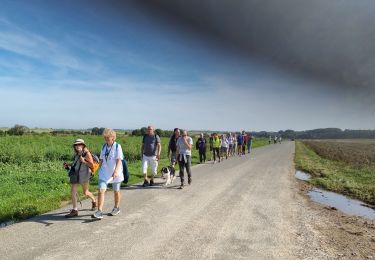
Trail Walking of 10.7 km to be discovered at Hauts-de-France, Somme, Pargny. This trail is proposed by tracegps.

Description

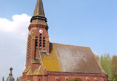
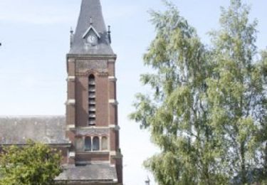
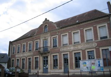
Circuit proposé par la Communauté de Communes du Pays Neslois. Départ de la mairie de Pargny. Ne manquez pas à Pargny, l’église Saint Sulpice, de construction moderne mais curieuse à l’intérieur. A Falvy, l’église Saint Benoîte (12ème siècle), et à Bethencourt-sur-Somme, l’église moderne de l’assomption de la Saint-Vierge ainsi que le cimetière militaire allemand 1914-18 vous donneront envie de faire cette balade. Retrouvez cette randonnée sur le site de la Communauté de Communes du Pays Neslois.

Elevation profile

Photos

Positioning

Country:
France
Region :
Hauts-de-France
Department/Province :
Somme
Municipality :
Pargny
Location:
Unknown
Start:(UTM)
496615 ; 5518274 (31U) N.

Trails nearby

Trail Mountain bike Saint-Christ-Briost - brie - Photo
Mountain bike
alainwald

Mountain bike

Very easy
Saint-Christ-Briost, Hauts-de-France, Somme, France
60 km | 65 km-effort
3h 38min
Yes
Trail Walking Pargny - Circuit du clos Bouteille -Pargny - Photo
Walking
terminio

Walking

Easy
Pargny, Hauts-de-France, Somme, France
11.5 km | 12.4 km-effort
2h 50min
Yes
Trail Walking Voyennes - La Courtemanche - Voyennes - Photo
Walking
tracegps

Walking

Medium
(1)
Voyennes, Hauts-de-France, Somme, France
10.1 km | 11 km-effort
2h 40min
Yes
Trail Walking Potte - Circuit des Calvaires - Autour du Pré Lacroix - Potte - Photo
Walking
tracegps

Walking

Medium
Potte, Hauts-de-France, Somme, France
9.3 km | 9.8 km-effort
3h 0min
Yes
Trail Walking Pargny - Circuit du Fief Doré - Pargny - Photo
Walking
tracegps

Walking

Medium
Pargny, Hauts-de-France, Somme, France
10.7 km | 11.5 km-effort
2h 40min
Yes
Trail Walking Voyennes - Circuit de la Courtemanche  -  Voyennes - Photo
Walking
tracegps

Walking

Medium
Voyennes, Hauts-de-France, Somme, France
11.9 km | 12.9 km-effort
3h 0min
Yes
Trail Walking Mesnil-Saint-Nicaise - randonnée de la fête du sport  - Photo
Walking
José800

Walking

Easy
Mesnil-Saint-Nicaise, Hauts-de-France, Somme, France
9.9 km | 10.8 km-effort
2h 4min
Yes
Trail Walking Pargny - le clos bouteille - Photo
Walking
José800

Walking

Medium
Pargny, Hauts-de-France, Somme, France
9.5 km | 10.3 km-effort
2h 49min
Yes
Trail Walking Pargny - le Fief Doré à  Pargny 80 - Photo
Walking
José800

Walking

Difficult
Pargny, Hauts-de-France, Somme, France
11.6 km | 12.6 km-effort
2h 40min
Yes


Close
My subscriptions