Trail Other activity Louisfert - Louisfert 8,6 km - Photo
© OpenStreetMap contributors
Length
Length
8.6 km
Max alt
Max alt
76 m
Uphill gradient
Uphill gradient
81 m
Km-Effort
Km-Effort  
9.6 km
Min alt
Min alt
43 m
Downhill gradient
Downhill gradient
81 m
Boucle
Boucle
Yes
Creation date :
2019-04-02 12:17:07.4
Updated on :
2019-04-02 12:17:07.4

(0 Reviews)

Other activity
Other activity
3h00
Difficulty : Easy

Scan this QR Code to open this trail in the SityTrail application

FREE GPS app for hiking

Logo SityTrail SityTrail

IGN / Geographical institutes

Download SityTrail from the App Store Download SityTrail from Google Play

Logo SityTrail SityTrail World

The world is yours!

Download SityTrail from the App Store Download SityTrail from Google Play Download SityTrail on Huawei AppGallery

About

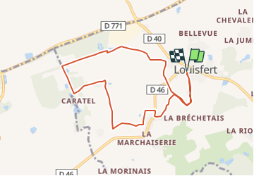
Trail Other activity of 8.6 km to be discovered at Pays de la Loire, Loire-Atlantique, Louisfert. This trail is proposed by neoroll44.

Description

Les sentiers d'émilie. L'école buisonnière.

Elevation profile

Positioning

Country:
France
Region :
Pays de la Loire
Department/Province :
Loire-Atlantique
Municipality :
Louisfert
Location:
Unknown
Start:(UTM)
617485 ; 5281330 (30T) N.

Trails nearby

Trail Mountain bike Châteaubriant - Grande boucle castelbriantaise - Photo
Mountain bike
tracegps

Mountain bike

Difficult
Châteaubriant, Pays de la Loire, Loire-Atlantique, France
47 km | 53 km-effort
4h 0min
Yes
Trail Mountain bike Châteaubriant - Parcours VTT castelbriantais - Photo
Mountain bike
tracegps

Mountain bike

Medium
Châteaubriant, Pays de la Loire, Loire-Atlantique, France
16 km | 17.8 km-effort
1h 30min
Yes
Trail Walking Saint-Aubin-des-Châteaux - Etangs et calvaire de St Aubin des Chateaux 13km - Photo
Walking
yago1404

Walking

Difficult
(1)
Saint-Aubin-des-Châteaux, Pays de la Loire, Loire-Atlantique, France
12.7 km | 14.5 km-effort
3h 21min
Yes
Trail Mountain bike Châteaubriant - chateaubriant-rochefort en terre - Photo
Mountain bike
gwenleterrible

Mountain bike

Difficult
Châteaubriant, Pays de la Loire, Loire-Atlantique, France
90 km | 102 km-effort
6h 51min
No
Trail Walking Louisfert - La Cône - Photo
Walking
neoroll44

Walking

Easy
Louisfert, Pays de la Loire, Loire-Atlantique, France
14.9 km | 16.7 km-effort
3h 42min
Yes
Trail Walking Louisfert - Le Bois Vert - Photo
Walking
neoroll44

Walking

Easy
Louisfert, Pays de la Loire, Loire-Atlantique, France
10.7 km | 12.1 km-effort
2h 40min
Yes
Trail Walking Saint-Aubin-des-Châteaux - randogps44-177 - Photo
Walking
chasle

Walking

Easy
Saint-Aubin-des-Châteaux, Pays de la Loire, Loire-Atlantique, France
22 km | 24 km-effort
5h 22min
Yes
Trail Walking Saint-Aubin-des-Châteaux - SityTrail - Saint Aubin des chateaux 2012-02-04 - Photo
Walking
chasle

Walking

Easy
Saint-Aubin-des-Châteaux, Pays de la Loire, Loire-Atlantique, France
16.7 km | 19.3 km-effort
4h 44min
Yes
Trail Walking Saint-Aubin-des-Châteaux - Sentier étangs et calvaires - Photo
Walking
neitag61

Walking

Medium
Saint-Aubin-des-Châteaux, Pays de la Loire, Loire-Atlantique, France
15.5 km | 17.8 km-effort
4h 0min
Yes


Close
My subscriptions