Trail Cycle Lachaussée - Autour de l'étang de Lachaussée... entre eau et air, Circuit n° 4 - Photo

Autour de l'étang de Lachaussée... entre eau et air, Circuit n° 4

 tracegps
tracegps

User

© OpenStreetMap contributors
Length
Length
26 km
Max alt
Max alt
259 m
Uphill gradient
Uphill gradient
243 m
Km-Effort
Km-Effort  
29 km
Min alt
Min alt
200 m
Downhill gradient
Downhill gradient
239 m
Boucle
Boucle
Yes
Creation date :
2014-12-10 00:00:00.0
Updated on :
2014-12-10 00:00:00.0

(0 Reviews)

Cycle
Cycle
1h30
Difficulty : Medium

Scan this QR Code to open this trail in the SityTrail application

FREE GPS app for hiking

Logo SityTrail SityTrail

IGN / Geographical institutes

Download SityTrail from the App Store Download SityTrail from Google Play

Logo SityTrail SityTrail World

The world is yours!

Download SityTrail from the App Store Download SityTrail from Google Play Download SityTrail on Huawei AppGallery

About

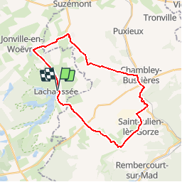
Trail Cycle of 26 km to be discovered at Grand Est, Meuse, Lachaussée. This trail is proposed by tracegps.

Description

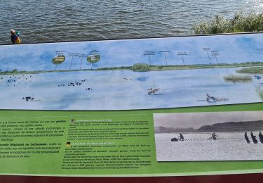
Le Parc Naturel Régional de Lorraine vous propose cette promenade qui ravira petits et grands autour d’un site remarquable inscrit au niveau international sur la protection des zones humides. Ici, les étangs, prairies et lisiéres de forêt acceuillent de nombreuses espèces animales et végétales. Le village-étang incite à la découverte. Départ de Lachaussée. Retrouvez ici le plan et descriptif du circuit. Vous pouvez obtenir le guide par courrier auprés du Parc Naturel Régional de Lorraine.

Elevation profile

Photos

Positioning

Country:
France
Region :
Grand Est
Department/Province :
Meuse
Municipality :
Lachaussée
Location:
Unknown
Start:(UTM)
706156 ; 5435477 (31U) N.

Trails nearby

Trail Walking Lachaussée - Lachaussée - étangs et prairies  - Photo
Walking
jean-marie.parachini

Walking

Medium
Lachaussée, Grand Est, Meuse, France
6.7 km | 7.3 km-effort
6h 1min
Yes
Trail Walking Lachaussée - Étang Lachaussée - Photo
Walking
Jean ANDRE

Walking

Medium
Lachaussée, Grand Est, Meuse, France
11.3 km | 12.6 km-effort
2h 31min
Yes
Trail Walking Lachaussée - Etangs de Lachaussée - Photo
Walking
joelclaudel

Walking

Medium
(2)
Lachaussée, Grand Est, Meuse, France
15.1 km | 16.9 km-effort
3h 44min
Yes
Trail Horseback riding Hagéville - Hageville - Photo
Horseback riding
jcvmax

Horseback riding

Medium
Hagéville, Grand Est, Meurthe-et-Moselle, France
21 km | 23 km-effort
4h 57min
No
Trail Walking Lachaussée - lachaussee - Photo
Walking
luckyy

Walking

Medium
Lachaussée, Grand Est, Meuse, France
6.3 km | 6.9 km-effort
2h 24min
Yes
Trail Walking Lachaussée - Lachaussée  - Photo
Walking
Vigneux

Walking

Lachaussée, Grand Est, Meuse, France
6.3 km | 6.9 km-effort
1h 48min
No
Trail Mountain bike Lachaussée - lachaussee_hattonchatel_AR - Photo
Mountain bike
PascalKvtt

Mountain bike

Easy
Lachaussée, Grand Est, Meuse, France
41 km | 47 km-effort
4h 29min
Yes
Trail Cycle Lachaussée - Lorraine Tour Parc Ouest étape 6 - Photo
Cycle
alaindurbecq

Cycle

Very easy
Lachaussée, Grand Est, Meuse, France
52 km | 59 km-effort
5h 30min
No


Close
My subscriptions