Trail Cycle Xivray-et-Marvoisin - La forêt de la Reine et ses mystères, suite - Circuit n° 9 - Photo

La forêt de la Reine et ses mystères, suite - Circuit n° 9

 tracegps
tracegps

User

© OpenStreetMap contributors
Length
Length
31 km
Max alt
Max alt
289 m
Uphill gradient
Uphill gradient
239 m
Km-Effort
Km-Effort  
34 km
Min alt
Min alt
221 m
Downhill gradient
Downhill gradient
238 m
Boucle
Boucle
Yes
Creation date :
2014-12-10 00:00:00.0
Updated on :
2014-12-10 00:00:00.0

(0 Reviews)

Cycle
Cycle
2h30
Difficulty : Medium

Scan this QR Code to open this trail in the SityTrail application

FREE GPS app for hiking

Logo SityTrail SityTrail

IGN / Geographical institutes

Download SityTrail from the App Store Download SityTrail from Google Play

Logo SityTrail SityTrail World

The world is yours!

Download SityTrail from the App Store Download SityTrail from Google Play Download SityTrail on Huawei AppGallery

About

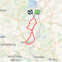
Trail Cycle of 31 km to be discovered at Grand Est, Meuse, Xivray-et-Marvoisin. This trail is proposed by tracegps.

Description

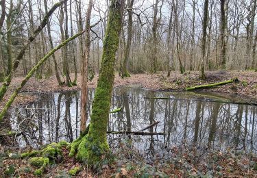
Ce parcours du Parc Naturel Régional de Lorraine est facile d’accés, il permet à toute une famille de faire une balade entre Côtes de Meuse et massif forestier de la reine en petite Woëvre. Départ de Xivray-et-Marvoisin. Retrouvez ici le plan et descriptif du circuit. Vous pouvez obtenir le guide par courrier auprés du Parc Naturel Régional de Lorraine.

Elevation profile

Photos

Positioning

Country:
France
Region :
Grand Est
Department/Province :
Meuse
Municipality :
Xivray-et-Marvoisin
Location:
Unknown
Start:(UTM)
701098 ; 5415962 (31U) N.

Trails nearby

Trail Walking Mandres-aux-Quatre-Tours - Mandres aux 4 Tours  -  les 9 étangs - Photo
Walking
jean-marie.parachini

Walking

Medium
Mandres-aux-Quatre-Tours, Grand Est, Meurthe-et-Moselle, France
12.2 km | 13.6 km-effort
5h 40min
Yes
Trail Cycle Mandres-aux-Quatre-Tours - La forêt de la Reine et ses mystères - Circuit n° 8 - Photo
Cycle
tracegps

Cycle

Difficult
Mandres-aux-Quatre-Tours, Grand Est, Meurthe-et-Moselle, France
50 km | 56 km-effort
3h 30min
Yes
Trail Mountain bike Mandres-aux-Quatre-Tours - forêt de la reine - Photo
Mountain bike
kikkko

Mountain bike

Very easy
Mandres-aux-Quatre-Tours, Grand Est, Meurthe-et-Moselle, France
30 km | 33 km-effort
2h 51min
Yes
Trail Mountain bike Montsec - Tour du Lac de Madine depuis Montsec - Photo
Mountain bike
noelphil

Mountain bike

Medium
Montsec, Grand Est, Meuse, France
24 km | 27 km-effort
1h 51min
Yes
Trail Electric bike Montsec - Tour de Madine - Photo
Electric bike
gmalgrase

Electric bike

Very easy
Montsec, Grand Est, Meuse, France
34 km | 39 km-effort
Unknown
Yes
Trail Walking Montsec - TOUR DU LA C DE LA MADINE DEPART BUTTE DE MONTSEC - Photo
Walking
Toyot 8

Walking

Medium
Montsec, Grand Est, Meuse, France
24 km | 28 km-effort
6h 19min
Yes
Trail Cycle Montsec - Montsec Tour lac de Madine 32 km - Photo
Cycle
alaindurbecq

Cycle

Very easy
Montsec, Grand Est, Meuse, France
31 km | 35 km-effort
2h 1min
Yes
Trail Other activity Mandres-aux-Quatre-Tours - mandres - Photo
Other activity
kikkko

Other activity

Very easy
Mandres-aux-Quatre-Tours, Grand Est, Meurthe-et-Moselle, France
13.2 km | 14.6 km-effort
1h 21min
Yes
Trail Via ferrata Montsec - madine  - Photo
Via ferrata
cameleo

Via ferrata

Easy
Montsec, Grand Est, Meuse, France
8 km | 9.3 km-effort
Unknown
No


Close
My subscriptions