Trail Motor Sainte-Ode - Saisons de la Photo 2022 - Amberloup/Tenneville - Photo

Saisons de la Photo 2022 - Amberloup/Tenneville

Randonnées de la Grande Forêt de Saint-Hubert GUIDE+

© OpenStreetMap contributors
Length
Length
58 km
Max alt
Max alt
494 m
Uphill gradient
Uphill gradient
984 m
Km-Effort
Km-Effort  
71 km
Min alt
Min alt
324 m
Downhill gradient
Downhill gradient
985 m
Boucle
Boucle
Yes
Creation date :
2019-05-06 16:39:50.05
Updated on :
2022-02-15 14:01:30.039

(0 Reviews)

Motor
Motor
2h00
Difficulty : Unknown

Scan this QR Code to open this trail in the SityTrail application

FREE GPS app for hiking

Logo SityTrail SityTrail

IGN / Geographical institutes

Download SityTrail from the App Store Download SityTrail from Google Play

Logo SityTrail SityTrail World

The world is yours!

Download SityTrail from the App Store Download SityTrail from Google Play Download SityTrail on Huawei AppGallery

About

Trail Motor of 58 km to be discovered at Wallonia, Luxembourg, Sainte-Ode. This trail is proposed by La Grande Forêt de Saint-Hubert.

Description

Découvrez grâce à ce circuit, les expositions "Saisons de la Photo en Grande Forêt de Saint-Hubert", passant par les communes de Sainte-Ode et Tenneville. www.lessaisonsdelaphoto.be

Elevation profile

Photos

Points of interest

Point of interest Sainte-Ode - Exposition de photos nature | Place communale (St-Ode) - Photo
La Grande Forêt de Saint-Hubert
Point of interest Sainte-Ode - Exposition de photos nature | Eglise de Houmont (St-Ode) - Photo
La Grande Forêt de Saint-Hubert
Point of interest Tenneville - Exposition de photos nature | Eglise de Tenneville - Photo
grande_foret_sthubert
Point of interest Tenneville - Exposition de photos nature | Laneuville-au-bois - Ancien cimetière (Tenneville)) - Photo
grande_foret_sthubert
Point of interest Tenneville - Exposition de photos nature | Eglise de Champlon (Tenneville) - Photo
grande_foret_sthubert
Point of interest Tenneville - Exposition de photos nature | Fontaine de Journal (Tenneville) - Photo
grande_foret_sthubert

Positioning

Country:
Belgium
Region :
Wallonia
Department/Province :
Luxembourg
Municipality :
Sainte-Ode
Location:
Unknown
Start:(UTM)
680760 ; 5545701 (31U) N.

Trails nearby

Trail Walking Sainte-Ode - RB-LUX-08 - Raccourci - De part et d’autre de l’Ourthe occidentale - Photo
Walking
PRO

Walking

Difficult
(2)
Sainte-Ode, Wallonia, Luxembourg, Belgium
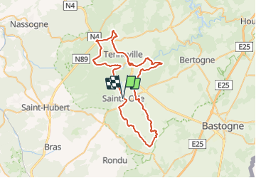
15.2 km | 18.6 km-effort
4h 13min
Yes
Trail Walking Sainte-Ode - Tonny - Promenade de Tonny (A6) - Photo
Walking
GUIDE+

Walking

Medium
(3)
Sainte-Ode, Wallonia, Luxembourg, Belgium
9.5 km | 12.2 km-effort
2h 36min
Yes
Trail Walking Sainte-Ode - Beauplateau - Promenade du Pleurotte (T7) - Photo
Walking
GUIDE+

Walking

Medium
(2)
Sainte-Ode, Wallonia, Luxembourg, Belgium
5.5 km | 6.9 km-effort
1h 29min
Yes
Trail Walking Sainte-Ode - Lavacherie - Promenade de la Bonne Dame (L1) - Photo
Walking
GUIDE+

Walking

Medium
(4)
Sainte-Ode, Wallonia, Luxembourg, Belgium
7.7 km | 10 km-effort
2h 10min
Yes
Trail Walking Sainte-Ode - Amberloup, Natura 2000 - Des sites qui valent le détour. Lx11 - Photo
Walking
GUIDE+

Walking

Easy
(4)
Sainte-Ode, Wallonia, Luxembourg, Belgium
4.2 km | 5 km-effort
1h 6min
Yes
Trail Walking Sainte-Ode - RB-LUX-08 - De part et d’autre de l’Ourthe occidentale - Photo
Walking
PRO

Walking

Medium
(1)
Sainte-Ode, Wallonia, Luxembourg, Belgium
23 km | 29 km-effort
6h 14min
Yes
Trail On foot Sainte-Ode - Sainte-ode - Photo
On foot
gossim2

On foot

Easy
(3)
Sainte-Ode, Wallonia, Luxembourg, Belgium
8.9 km | 11.9 km-effort
Unknown
Yes
Trail On foot Sainte-Ode - Dans Freyr par Bokaissart - Photo
On foot
lancelot.be

On foot

Medium
(1)
Sainte-Ode, Wallonia, Luxembourg, Belgium
4.6 km | 5.9 km-effort
1h 25min
Yes
Trail Walking Sainte-Ode - Beauplateau - Le sentier du Coprin (GTA 4) - Photo
Walking
GUIDE+

Walking

Very difficult
(2)
Sainte-Ode, Wallonia, Luxembourg, Belgium
16.6 km | 20 km-effort
4h 20min
Yes


Close
My subscriptions