Trail Cycle Marcilly-le-Hayer - Circuit des dolmens et polissoirs - Marcilly le Hayer  - Photo

Circuit des dolmens et polissoirs - Marcilly le Hayer

 tracegps
tracegps

User

© OpenStreetMap contributors
Length
Length
83 km
Max alt
Max alt
267 m
Uphill gradient
Uphill gradient
955 m
Km-Effort
Km-Effort  
96 km
Min alt
Min alt
89 m
Downhill gradient
Downhill gradient
954 m
Boucle
Boucle
Yes
Creation date :
2014-12-10 00:00:00.0
Updated on :
2014-12-10 00:00:00.0

(0 Reviews)

Cycle
Cycle
4h00
Difficulty : Difficult

Scan this QR Code to open this trail in the SityTrail application

FREE GPS app for hiking

Logo SityTrail SityTrail

IGN / Geographical institutes

Download SityTrail from the App Store Download SityTrail from Google Play

Logo SityTrail SityTrail World

The world is yours!

Download SityTrail from the App Store Download SityTrail from Google Play Download SityTrail on Huawei AppGallery

About

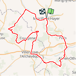
Trail Cycle of 83 km to be discovered at Grand Est, Aube, Marcilly-le-Hayer. This trail is proposed by tracegps.

Description

Proposé par le Comité Départemental du Tourisme de l'Aube, un circuit créé et validé par la Fédération Départementale du Cyclotourisme de l’Aube. Circuit des dolmens et polissoirs – 81 km - Eglise de Rigny-le-Ferron et de Marcilly le Hayer - Polissoirs et dolmens - Etang de Paisy-Cosdon - Collégiale Notre-Dame de Villemaur-sur-Vanne

Elevation profile

Photos

Points of interest

Point of interest Marcilly-le-Hayer - cycloguide N?05 Circuit des dolmens et polissoirs 82.794 km - Photo
tracegps

Positioning

Country:
France
Region :
Grand Est
Department/Province :
Aube
Municipality :
Marcilly-le-Hayer
Location:
Unknown
Start:(Dec)
Start:(UTM)
547041 ; 5355123 (31U) N.

Trails nearby

Trail Walking Marcilly-le-Hayer - Marcilly le Hayer (Dolmens) - Photo
Walking
Daneel-89

Walking

Very easy
Marcilly-le-Hayer, Grand Est, Aube, France
11.9 km | 13 km-effort
3h 0min
Yes
Trail On foot Villadin - Villadin - Photo
On foot
Alain Picard

On foot

Medium
Villadin, Grand Est, Aube, France
12.7 km | 16 km-effort
Unknown
Yes
Trail Mountain bike Villadin - Viladin 17.3.24 - Photo
Mountain bike
Tollard

Mountain bike

Difficult
Villadin, Grand Est, Aube, France
26 km | 35 km-effort
3h 5min
No
Trail On foot Marcilly-le-Hayer - vallée de l'orvin - Photo
On foot
genndor

On foot

Medium
Marcilly-le-Hayer, Grand Est, Aube, France
26 km | 29 km-effort
Unknown
Yes
Trail On foot Marcilly-le-Hayer - vallée de l'orvin - Photo
On foot
genndor

On foot

Medium
Marcilly-le-Hayer, Grand Est, Aube, France
26 km | 29 km-effort
Unknown
Yes


Close
My subscriptions