Trail Cycle Saint-Mards-en-Othe - Circuit de Saint-Mards-en-Othe - Photo

Circuit de Saint-Mards-en-Othe

 tracegps
tracegps

User

© OpenStreetMap contributors
Length
Length
26 km
Max alt
Max alt
291 m
Uphill gradient
Uphill gradient
361 m
Km-Effort
Km-Effort  
31 km
Min alt
Min alt
170 m
Downhill gradient
Downhill gradient
361 m
Boucle
Boucle
Yes
Creation date :
2014-12-10 00:00:00.0
Updated on :
2014-12-10 00:00:00.0

(0 Reviews)

Cycle
Cycle
1h30
Difficulty : Easy

Scan this QR Code to open this trail in the SityTrail application

FREE GPS app for hiking

Logo SityTrail SityTrail

IGN / Geographical institutes

Download SityTrail from the App Store Download SityTrail from Google Play

Logo SityTrail SityTrail World

The world is yours!

Download SityTrail from the App Store Download SityTrail from Google Play Download SityTrail on Huawei AppGallery

About

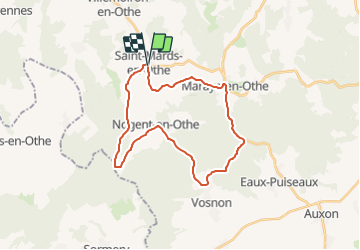
Trail Cycle of 26 km to be discovered at Grand Est, Aube, Saint-Mards-en-Othe. This trail is proposed by tracegps.

Description

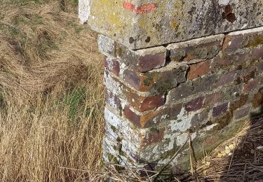
Circuit proposé par l'office de Tourisme du Pays d'Othe, vallée de la Vanne et le Cyclo Club Othéen. Départ place de la mairie de Saint-Mards-en-Othe. Le lavoir de Saint Mards en orthe date de 1845. Il est le plus imposant du département par ses dimensions. Il était prévu pour une soixantaine de personnes. Construit en briques provenant des fourneaux du Gaty, il était éclairé de 10 baies vitrées en plein cintre. Il était alimenté par la source Saint Bouin. Retrouvez le circuit a télécharger sur le site de l'office de tourisme du Pays d'Othe, vallée de la Vanne.

Elevation profile

Photos

Positioning

Country:
France
Region :
Grand Est
Department/Province :
Aube
Municipality :
Saint-Mards-en-Othe
Location:
Unknown
Start:(UTM)
559462 ; 5335779 (31U) N.

Trails nearby

Trail Walking Saint-Mards-en-Othe - De place en place - Saint Mards en Othe - Photo
Walking
tracegps

Walking

Difficult
(1)
Saint-Mards-en-Othe, Grand Est, Aube, France
16.1 km | 19.8 km-effort
4h 0min
Yes
Trail Walking Maraye-en-Othe - Maraye (11+13km) le 21/07/2020 - Photo
Walking
francis1952

Walking

Medium
Maraye-en-Othe, Grand Est, Aube, France
25 km | 30 km-effort
5h 14min
Yes
Trail Walking Aix-Villemaur-Pâlis - La Vove - Aix en Othe - Photo
Walking
tracegps

Walking

Medium
(1)
Aix-Villemaur-Pâlis, Grand Est, Aube, France
10.2 km | 12.3 km-effort
2h 30min
Yes
Trail Walking Aix-Villemaur-Pâlis - La Vove - Bois de la Brosse - Photo
Walking
Daneel-89

Walking

Easy
Aix-Villemaur-Pâlis, Grand Est, Aube, France
9.8 km | 11.9 km-effort
3h 0min
Yes
Trail Cycle Villemoiron-en-Othe - Circuit de Villemoiron en Othe - Photo
Cycle
tracegps

Cycle

Easy
Villemoiron-en-Othe, Grand Est, Aube, France
33 km | 39 km-effort
1h 45min
Yes
Trail Walking Maraye-en-Othe - Le circuit des Voirloups - Maraye-en-Othe - Photo
Walking
tracegps

Walking

Very difficult
(1)
Maraye-en-Othe, Grand Est, Aube, France
19.1 km | 24 km-effort
4h 49min
Yes
Trail Walking Maraye-en-Othe - Les Vergers de Champcharme - Maraye-en-Othe - Photo
Walking
tracegps

Walking

Difficult
Maraye-en-Othe, Grand Est, Aube, France
14.3 km | 18.6 km-effort
3h 34min
Yes
Trail Walking Maraye-en-Othe - Maraye,Nogent,Vosnon,Puiseaux,Chenu,Chamsicourt - Photo
Walking
francis1952

Walking

Difficult
Maraye-en-Othe, Grand Est, Aube, France
31 km | 39 km-effort
6h 11min
Yes
Trail Walking Maraye-en-Othe - Maraye 26km le 08.10.2021 - Photo
Walking
francis1952

Walking

Difficult
Maraye-en-Othe, Grand Est, Aube, France
26 km | 32 km-effort
5h 27min
Yes


Close
My subscriptions