Trail Walking Giberga Apartments - And : Cami Solà- Camí Obaga - Photo

And : Cami Solà- Camí Obaga

 phidge
phidge

User

© OpenStreetMap contributors
Length
Length
8.2 km
Max alt
Max alt
1948 m
Uphill gradient
Uphill gradient
706 m
Km-Effort
Km-Effort  
17.5 km
Min alt
Min alt
1273 m
Downhill gradient
Downhill gradient
696 m
Boucle
Boucle
No
Creation date :
2019-01-20 16:38:41.369
Updated on :
2019-01-20 16:38:41.38

(0 Reviews)

Walking
Walking
--
Difficulty : Easy

Scan this QR Code to open this trail in the SityTrail application

FREE GPS app for hiking

Logo SityTrail SityTrail

IGN / Geographical institutes

Download SityTrail from the App Store Download SityTrail from Google Play

Logo SityTrail SityTrail World

The world is yours!

Download SityTrail from the App Store Download SityTrail from Google Play Download SityTrail on Huawei AppGallery

About

Trail Walking of 8.2 km to be discovered at Andorra. This trail is proposed by phidge.

Description

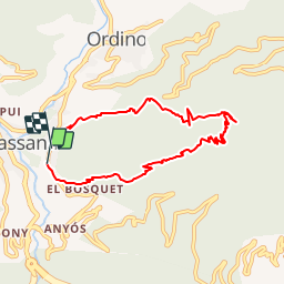
Longueur: 8,56 kilomètres
Altitude min: 1 260 mètres, max: 1 940 mètres
Dénivelé cum. montée: 656 mètres, descente: 517 mètres
Degré de difficulté: skill Facile
Durée:   2 hours 9 minutes

Sortim del Poble de l'Aldosa per caminar enmig dels boscos pel camí del solà fins arribar a la font del Mallol. Allà baixem prenent el camí de l'Obaga

Elevation profile

Positioning

Country:
Andorra
Region :
La Massana
Department/Province :
La Massana
Municipality :
Giberga Apartments
Location:
Unknown
Start:(UTM)
378708 ; 4710993 (31T) N.

Trails nearby

Trail Walking  - Andorre TSM groupe 2 mardi 10 septembre matin - Photo
Walking
zanogueb

Walking

Easy
, , , Andorra
4 km | 5.5 km-effort
1h 46min
Yes
Trail Walking  - chemin de la fontanas et bailmadriu - Photo
Walking
JEANJOSY

Walking

Medium
, , , Andorra
14.2 km | 23 km-effort
5h 38min
Yes
Trail Walking  - Casamanya S + pic del Miguel + Casamanya S - Photo
Walking
Jacpro

Walking

Difficult
, , , Andorra
7.5 km | 18.4 km-effort
2h 58min
Yes
Trail Other activity  - Engolasters Ramió - Photo
Other activity
elviking

Other activity

Medium
, , , Andorra
7.2 km | 11.2 km-effort
2h 50min
No
Trail Walking  - 49 - Itinéraire de Perafita - Photo
Walking
hbonnard

Walking

Difficult
, , , Andorra
9.1 km | 22 km-effort
4h 12min
No
Trail Walking  - 54 - Lac Blau - Photo
Walking
hbonnard

Walking

Difficult
, , , Andorra
14.9 km | 31 km-effort
6h 17min
No
Trail Walking  - 8 - Pic de Casamanya - Photo
Walking
hbonnard

Walking

Easy
, , , Andorra
3.6 km | 10.9 km-effort
2h 29min
No
Trail Motor  - a-spanje-bergen-andorra-en-spanje - Photo
Motor
gpstracks

Motor

Very easy
, , , Andorra
219 km | 497 km-effort
Unknown
Yes
Trail Walking  - Arinsal - Arans -Lliort - Photo
Walking
phidge

Walking

Medium
, , , Andorra
16.1 km | 41 km-effort
Unknown
Yes


Close
My subscriptions