Trail Other activity Trois-Ponts - 20190407 Wannes - Photo

20190407 Wannes

 xtof_ts
xtof_ts

User

© OpenStreetMap contributors
Length
Length
8.7 km
Max alt
Max alt
575 m
Uphill gradient
Uphill gradient
215 m
Km-Effort
Km-Effort  
11.5 km
Min alt
Min alt
448 m
Downhill gradient
Downhill gradient
215 m
Boucle
Boucle
Yes
Creation date :
2019-05-07 00:16:02.756
Updated on :
2019-05-07 00:16:02.756

(0 Reviews)

Other activity
Other activity
2h27
Difficulty : Easy

Scan this QR Code to open this trail in the SityTrail application

FREE GPS app for hiking

Logo SityTrail SityTrail

IGN / Geographical institutes

Download SityTrail from the App Store Download SityTrail from Google Play

Logo SityTrail SityTrail World

The world is yours!

Download SityTrail from the App Store Download SityTrail from Google Play Download SityTrail on Huawei AppGallery

About

Trail Other activity of 8.7 km to be discovered at Wallonia, Liège, Trois-Ponts. This trail is proposed by xtof_ts.

Elevation profile

Positioning

Country:
Belgium
Region :
Wallonia
Department/Province :
Liège
Municipality :
Trois-Ponts
Location:
Wanne
Start:(UTM)
709556 ; 5583513 (31U) N.

Trails nearby

Trail Walking Trois-Ponts - RB-Lg-29_Wanne - Photo
Walking
PRO

Walking

Very difficult
(5)
Trois-Ponts, Wallonia, Liège, Belgium
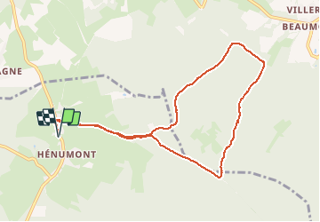
22 km | 29 km-effort
6h 9min
Yes
Trail Walking Trois-Ponts - Logbiermé. Natura 2000, des sites qui valent le détour ! Lg5 - Photo
Walking
GUIDE+

Walking

Easy
(9)
Trois-Ponts, Wallonia, Liège, Belgium
8.4 km | 10.9 km-effort
Unknown
Yes
Trail Walking Stavelot - 2021-06-30_12h14m27_stavelot_13km_new - Photo
Walking
GUIDE
mumu.larandonneuse

Walking

Medium
(2)
Stavelot, Wallonia, Liège, Belgium
13.4 km | 19.8 km-effort
4h 30min
Yes
Trail Walking Stavelot - 2021-03-10_14h59m08_1227 - Photo
Walking
GUIDE
mumu.larandonneuse

Walking

Difficult
(3)
Stavelot, Wallonia, Liège, Belgium
18.8 km | 26 km-effort
5h 53min
No
Trail Walking Trois-Ponts - RB-Lg-29_Wanne_via-racc-2 - Photo
Walking
PRO

Walking

Very difficult
(3)
Trois-Ponts, Wallonia, Liège, Belgium
14.2 km | 19.2 km-effort
4h 21min
Yes
Trail Walking Malmedy - RB-LG-09 - Sur les hauteurs dominant la haute vallée de l’Amblève et la Warche - Photo
Walking
PRO

Walking

Medium
(4)
Malmedy, Wallonia, Liège, Belgium
26 km | 34 km-effort
7h 12min
Yes
Trail Walking Stavelot - Chemin des Sources |stage 3 STAVELOT - HOCKAI - Photo
Walking
PRO

Walking

Very difficult
(1)
Stavelot, Wallonia, Liège, Belgium
19 km | 25 km-effort
5h 45min
No
Trail On foot Malmedy - Brasserie de Bellevaux - Photo
On foot
PRO

On foot

Easy
(3)
Malmedy, Wallonia, Liège, Belgium
10.2 km | 13.1 km-effort
4h 0min
Yes
Trail Trail Stavelot - Extratrail - Stavelot (red) 23km - Photo
Trail
PRO

Trail

Very difficult
(1)
Stavelot, Wallonia, Liège, Belgium
23 km | 35 km-effort
Unknown
Yes


Close
My subscriptions