Trail Cycle Deinze - Deinze - Vallée de la Lys 30 kms  Knoopunt - Photo

Deinze - Vallée de la Lys 30 kms Knoopunt

© OpenStreetMap contributors
Length
Length
31 km
Max alt
Max alt
27 m
Uphill gradient
Uphill gradient
190 m
Km-Effort
Km-Effort  
34 km
Min alt
Min alt
1 m
Downhill gradient
Downhill gradient
189 m
Boucle
Boucle
Yes
Creation date :
2014-12-10 00:00:00.0
Updated on :
2014-12-10 00:00:00.0

(0 Reviews)

Cycle
Cycle
--
Difficulty : Easy

Scan this QR Code to open this trail in the SityTrail application

FREE GPS app for hiking

Logo SityTrail SityTrail

IGN / Geographical institutes

Download SityTrail from the App Store Download SityTrail from Google Play

Logo SityTrail SityTrail World

The world is yours!

Download SityTrail from the App Store Download SityTrail from Google Play Download SityTrail on Huawei AppGallery

About

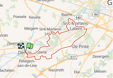
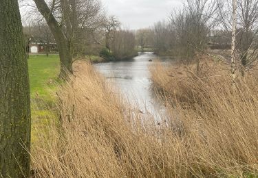
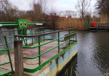
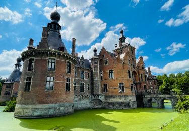
Trail Cycle of 31 km to be discovered at Flanders, East Flanders, Deinze. This trail is proposed by pinkzebra.

Description

www.fietsnet.be pour le tracé. Balade pour www.CycloPlus.be

Elevation profile

Points of interest

Point of interest Deinze - 6 +9 - Photo
pinkzebra
DEINZE 
Point of interest Deinze - 9 +11 - Photo
pinkzebra
DEINZE 
Point of interest Deinze - 11 +12 - Photo
pinkzebra
DEINZE 
Point of interest Deinze - 12 +90 - Photo
pinkzebra
DEINZE 
Point of interest Deinze - 90 +86 - Photo
pinkzebra
DEINZE 
Point of interest Sint-Martens-Latem - 86 +76 - Photo
pinkzebra
SINT-MARTENS-LATEM 
Point of interest Sint-Martens-Latem - 76 +74 - Photo
pinkzebra
SINT-MARTENS-LATEM 
Point of interest Sint-Martens-Latem - 74 +67 - Photo
pinkzebra
SINT-MARTENS-LATEM 
Point of interest Ghent - 67 +88 - Photo
pinkzebra
GHENT 
Point of interest Ghent - 88 +79 - Photo
pinkzebra
GHENT 
Point of interest De Pinte - 79 +22 - Photo
pinkzebra
DE PINTE 
Point of interest De Pinte - 22 +23 - Photo
pinkzebra
DE PINTE 
Point of interest De Pinte - 23 +20 - Photo
pinkzebra
DE PINTE 
Point of interest Deinze - 20 +14 - Photo
pinkzebra
DEINZE 
Point of interest Deinze - 14 +13 - Photo
pinkzebra
DEINZE 
Point of interest Deinze - 13 +6 - Photo
pinkzebra
DEINZE 

Positioning

Country:
Belgium
Region :
Flanders
Department/Province :
East Flanders
Municipality :
Deinze
Location:
Deinze
Start:(UTM)
537181 ; 5648120 (31U) N.

Trails nearby

Trail On foot Zulte - Roger Raveelroute - Photo
On foot
PRO

On foot

Easy
Zulte, Flanders, East Flanders, Belgium
3.6 km | 3.9 km-effort
53min
Yes
Trail On foot Deinze - Ooidonkroute - Photo
On foot
PRO

On foot

Easy
Deinze, Flanders, East Flanders, Belgium
7.7 km | 8.2 km-effort
1h 52min
Yes
Trail On foot Zulte - Vlasrotersroute - Lus 1 - Photo
On foot
PRO

On foot

Easy
Zulte, Flanders, East Flanders, Belgium
11.3 km | 12.1 km-effort
2h 44min
Yes
Trail Walking Zulte - Roger_Raveelwandelroute - Photo
Walking
wandelroutes

Walking

Very easy
(1)
Zulte, Flanders, East Flanders, Belgium
3.7 km | 4 km-effort
Unknown
Yes
Trail Walking Deinze - Filliers Deinze  - Photo
Walking
pilmolt

Walking

Medium
Deinze, Flanders, East Flanders, Belgium
6.8 km | 7.5 km-effort
1h 32min
Yes
Trail Walking Deinze - Randonnée des Filliers à Deinze - Photo
Walking
GUIDE+

Walking

Medium
(1)
Deinze, Flanders, East Flanders, Belgium
7 km | 7.7 km-effort
1h 44min
Yes
Trail Walking Deinze - Le château d’Ooidonk à Deinze - Photo
Walking
Benjamin27

Walking

Medium
Deinze, Flanders, East Flanders, Belgium
7.7 km | 8.2 km-effort
1h 52min
Yes
Trail Walking Deinze - GR 129 : Deinze > Oudenaarde - Photo
Walking
jojolemarcheur

Walking

Easy
Deinze, Flanders, East Flanders, Belgium
34 km | 38 km-effort
8h 19min
No
Trail Walking Deinze - gottem deinze 24 km - Photo
Walking
GUIDE
rvapeldo

Walking

Easy
Deinze, Flanders, East Flanders, Belgium
24 km | 25 km-effort
5h 43min
Yes


Close
My subscriptions