Trail Running Villers-devant-le-Thour - 10 km à travers champs -  Villers Devant le Thour - Photo

10 km à travers champs - Villers Devant le Thour

 tracegps
tracegps

User

© OpenStreetMap contributors
Length
Length
10.8 km
Max alt
Max alt
134 m
Uphill gradient
Uphill gradient
119 m
Km-Effort
Km-Effort  
12.4 km
Min alt
Min alt
71 m
Downhill gradient
Downhill gradient
118 m
Boucle
Boucle
Yes
Creation date :
2014-12-10 00:00:00.0
Updated on :
2014-12-10 00:00:00.0

(0 Reviews)

Running
Running
1h00
Difficulty : Medium

Scan this QR Code to open this trail in the SityTrail application

FREE GPS app for hiking

Logo SityTrail SityTrail

IGN / Geographical institutes

Download SityTrail from the App Store Download SityTrail from Google Play

Logo SityTrail SityTrail World

The world is yours!

Download SityTrail from the App Store Download SityTrail from Google Play Download SityTrail on Huawei AppGallery

About

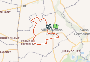
Trail Running of 10.8 km to be discovered at Grand Est, Ardennes, Villers-devant-le-Thour. This trail is proposed by tracegps.

Description

Départ et arrivée place de l’église. Circuit vallonné, exclusivement sur chemins à travers champs. Remarque: disparition récente du chemin sur environ 500m au kilomètre 7, passage en bordure de champ obligatoire.

Elevation profile

Positioning

Country:
France
Region :
Grand Est
Department/Province :
Ardennes
Municipality :
Villers-devant-le-Thour
Location:
Unknown
Start:(UTM)
578817 ; 5484420 (31U) N.

Trails nearby

Trail Walking Asfeld - Asfeld- Vieux les Asfeld A-R - Photo
Walking
mick211

Walking

Very easy
(1)
Asfeld, Grand Est, Ardennes, France
7.2 km | 7.8 km-effort
1h 44min
Yes


Close
My subscriptions