Trail Mountain bike Gelles - Etang de Banson - Gelles - Photo

Etang de Banson - Gelles

 tracegps
tracegps

User

© OpenStreetMap contributors
Length
Length
12.4 km
Max alt
Max alt
969 m
Uphill gradient
Uphill gradient
240 m
Km-Effort
Km-Effort  
15.6 km
Min alt
Min alt
846 m
Downhill gradient
Downhill gradient
240 m
Boucle
Boucle
Yes
Creation date :
2014-12-10 00:00:00.0
Updated on :
2014-12-10 00:00:00.0

(1 Reviews)

Mountain bike
Mountain bike
2h15
Difficulty : Medium

Scan this QR Code to open this trail in the SityTrail application

FREE GPS app for hiking

Logo SityTrail SityTrail

IGN / Geographical institutes

Download SityTrail from the App Store Download SityTrail from Google Play

Logo SityTrail SityTrail World

The world is yours!

Download SityTrail from the App Store Download SityTrail from Google Play Download SityTrail on Huawei AppGallery

About

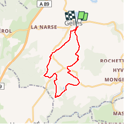
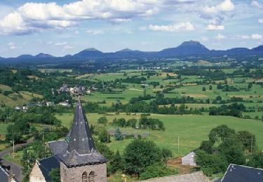
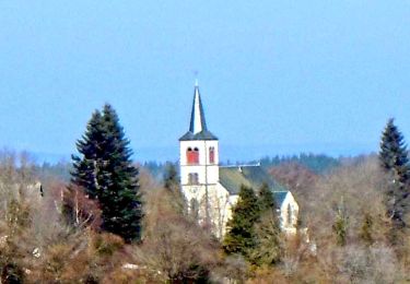
Trail Mountain bike of 12.4 km to be discovered at Auvergne-Rhône-Alpes, Puy-de-Dôme, Gelles. This trail is proposed by tracegps.

Description

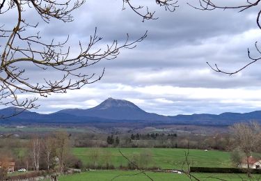
Circuit sur chemins et petites routes. Plusieurs points de vue, en particulier sur le massif du Sancy. Quelques montées raides mais courtes. Possibilités de raccourcis en shuntant certaines parties de la boucle.

Elevation profile

Photos

Positioning

Country:
France
Region :
Auvergne-Rhône-Alpes
Department/Province :
Puy-de-Dôme
Municipality :
Gelles
Location:
Unknown
Start:(UTM)
481681 ; 5068255 (31T) N.

Comments

Please log in to post a review or rate the element


Trails nearby

Trail Walking Saint-Pierre-Roche - St_Pierre_Roche_Sioulot - Photo
Walking
GUIDE
jagarnier

Walking

Easy
(1)
Saint-Pierre-Roche, Auvergne-Rhône-Alpes, Puy-de-Dôme, France
10.7 km | 13.2 km-effort
2h 51min
Yes
Trail Walking Gelles -  La roche branlante de Gelles - Photo
Walking
tracegps

Walking

Easy
(1)
Gelles, Auvergne-Rhône-Alpes, Puy-de-Dôme, France
7 km | 8.6 km-effort
2h 0min
Yes
Trail On foot Saint-Pierre-Roche - Le Sioulot - Photo
On foot
PRO

On foot

Easy
Saint-Pierre-Roche, Auvergne-Rhône-Alpes, Puy-de-Dôme, France
10 km | 12.3 km-effort
2h 47min
No
Trail Walking Saint-Pierre-Roche - St_Pierre_Roche_Villages - Photo
Walking
GUIDE
jagarnier

Walking

Medium
Saint-Pierre-Roche, Auvergne-Rhône-Alpes, Puy-de-Dôme, France
12.4 km | 16.7 km-effort
3h 33min
Yes
Trail Walking Gelles -  Etangs de Gelles 10km, 159m - Photo
Walking
gergovie

Walking

Medium
Gelles, Auvergne-Rhône-Alpes, Puy-de-Dôme, France
10.1 km | 12.2 km-effort
2h 43min
Yes
Trail Walking Gelles - Les Etangs de Gelles 19km 148m - Photo
Walking
gergovie

Walking

Medium
Gelles, Auvergne-Rhône-Alpes, Puy-de-Dôme, France
18.6 km | 23 km-effort
5h 1min
Yes
Trail Walking Gelles - Les Etangs de Gelles 9km 148m - Photo
Walking
gergovie

Walking

Medium
Gelles, Auvergne-Rhône-Alpes, Puy-de-Dôme, France
8.8 km | 10.6 km-effort
2h 24min
Yes
Trail Walking Bromont-Lamothe - Bromont_Puy_Neuffont - Photo
Walking
GUIDE
jagarnier

Walking

Medium
Bromont-Lamothe, Auvergne-Rhône-Alpes, Puy-de-Dôme, France
15 km | 19.1 km-effort
4h 30min
Yes
Trail Walking Cisternes-la-Forêt - Cisternes_Bois_Bauges - Photo
Walking
GUIDE
jagarnier

Walking

Medium
Cisternes-la-Forêt, Auvergne-Rhône-Alpes, Puy-de-Dôme, France
11.8 km | 15.2 km-effort
3h 30min
Yes


Close
My subscriptions