Trail Mountain bike Obernai - obernai ochsenlager rohtlach kreuzweg - Photo

obernai ochsenlager rohtlach kreuzweg

© OpenStreetMap contributors
Length
Length
40 km
Max alt
Max alt
962 m
Uphill gradient
Uphill gradient
1036 m
Km-Effort
Km-Effort  
54 km
Min alt
Min alt
182 m
Downhill gradient
Downhill gradient
1036 m
Boucle
Boucle
Yes
Creation date :
2014-12-10 00:00:00.0
Updated on :
2014-12-10 00:00:00.0

(2 Reviews)

Mountain bike
Mountain bike
4h30
Difficulty : Unknown

Scan this QR Code to open this trail in the SityTrail application

FREE GPS app for hiking

Logo SityTrail SityTrail

IGN / Geographical institutes

Download SityTrail from the App Store Download SityTrail from Google Play

Logo SityTrail SityTrail World

The world is yours!

Download SityTrail from the App Store Download SityTrail from Google Play Download SityTrail on Huawei AppGallery

About

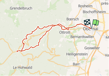
Trail Mountain bike of 40 km to be discovered at Grand Est, Bas-Rhin, Obernai. This trail is proposed by patrick67210.

Description

Depart sur le sentier de l'ehn ( attention sentier interdit aux vélos, Ochsenlager par  croix bleu à  klingentahl Arriver au ochsenlager suivre carrée bleu jusqu'à la rotlach pour reprendre la croix bleu vers les ruine du klagenfels et retour par le haut d'ottrot

Elevation profile

Positioning

Country:
France
Region :
Grand Est
Department/Province :
Bas-Rhin
Municipality :
Obernai
Location:
Unknown
Start:(UTM)
387928 ; 5368694 (32U) N.

Comments

Please log in to post a review or rate the element


Beau circuit


Trails nearby

Trail Walking Ottrott - Le Mont Sainte-Odile depuis Otrott - Photo
Walking
VacheKiri67

Walking

Medium
(1)
Ottrott, Grand Est, Bas-Rhin, France
13 km | 20 km-effort
6h 18min
Yes
Trail Walking Obernai - Obernai gare - Mont St Odile - Photo
Walking
tracegps

Walking

Difficult
(2)
Obernai, Grand Est, Bas-Rhin, France
20 km | 29 km-effort
5h 0min
Yes
Trail Mountain bike Ottrott - Sainte-Odile East-Face - Photo
Mountain bike
tracegps

Mountain bike

Difficult
(1)
Ottrott, Grand Est, Bas-Rhin, France
24 km | 39 km-effort
3h 0min
Yes
Trail On foot Rosheim - Circuit du Vignoble - Photo
On foot
PRO

On foot

Easy
Rosheim, Grand Est, Bas-Rhin, France
8.8 km | 11.7 km-effort
2h 38min
Yes
Trail On foot Bischoffsheim - Circuit des Balcons - Photo
On foot
PRO

On foot

Easy
(1)
Bischoffsheim, Grand Est, Bas-Rhin, France
12.4 km | 15.4 km-effort
3h 30min
Yes
Trail Walking Obernai - sentier des merveilles - Photo
Walking
semila

Walking

Difficult
(1)
Obernai, Grand Est, Bas-Rhin, France
11 km | 16.6 km-effort
4h 8min
Yes
Trail Mountain bike Rosheim - schnacker tour le grand 8 circuit magique - Photo
Mountain bike
raphnou

Mountain bike

Difficult
(1)
Rosheim, Grand Est, Bas-Rhin, France
29 km | 39 km-effort
2h 30min
Yes
Trail Walking Rosenwiller - 2015-05-17 Marche Gourmande Rosenwiller - Photo
Walking
GUIDE
holtzv

Walking

Easy
(1)
Rosenwiller, Grand Est, Bas-Rhin, France
8.8 km | 11 km-effort
2h 23min
No
Trail Walking Rosheim - Les balcons de Rosheim (variante) - Photo
Walking
Mich&Agnès

Walking

Easy
Rosheim, Grand Est, Bas-Rhin, France
13.4 km | 16.8 km-effort
3h 48min
Yes


Close
My subscriptions