Trail Mountain bike Saint-Saulge - Le Tacot Vert - Saint Saulge - Photo

Le Tacot Vert - Saint Saulge

 tracegps
tracegps

User

© OpenStreetMap contributors
Length
Length
6.8 km
Max alt
Max alt
331 m
Uphill gradient
Uphill gradient
101 m
Km-Effort
Km-Effort  
8.1 km
Min alt
Min alt
272 m
Downhill gradient
Downhill gradient
100 m
Boucle
Boucle
Yes
Creation date :
2014-12-10 00:00:00.0
Updated on :
2014-12-10 00:00:00.0

(0 Reviews)

Mountain bike
Mountain bike
45m
Difficulty : Easy

Scan this QR Code to open this trail in the SityTrail application

FREE GPS app for hiking

Logo SityTrail SityTrail

IGN / Geographical institutes

Download SityTrail from the App Store Download SityTrail from Google Play

Logo SityTrail SityTrail World

The world is yours!

Download SityTrail from the App Store Download SityTrail from Google Play Download SityTrail on Huawei AppGallery

About

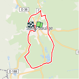
Trail Mountain bike of 6.8 km to be discovered at Bourgogne-Franche-Comté, Nièvre, Saint-Saulge. This trail is proposed by tracegps.

Description

Un circuit idéal pour la balade familiale autour de St Saulge.

Elevation profile

Photos

Positioning

Country:
France
Region :
Bourgogne-Franche-Comté
Department/Province :
Nièvre
Municipality :
Saint-Saulge
Location:
Unknown
Start:(UTM)
538873 ; 5216778 (31T) N.

Trails nearby

Trail Running Saint-Saulge - Le Tacot Vert - Saint Saulge - Photo
Running
tracegps

Running

Medium
Saint-Saulge, Bourgogne-Franche-Comté, Nièvre, France
6.8 km | 8.1 km-effort
45min
Yes
Trail Walking Saint-Saulge - Le Tacot Vert - Saint Saulge - Photo
Walking
tracegps

Walking

Easy
Saint-Saulge, Bourgogne-Franche-Comté, Nièvre, France
6.8 km | 8.1 km-effort
1h 0min
Yes
Trail Walking Saint-Saulge - Les curiosités de Saint-Saulge Borgonne Franche-Conté - Photo
Walking
FouargePatrick

Walking

Medium
Saint-Saulge, Bourgogne-Franche-Comté, Nièvre, France
7.2 km | 9.5 km-effort
2h 8min
Yes
Trail Walking Crux-la-Ville - Etang du merle - Photo
Walking
kronio

Walking

Medium
Crux-la-Ville, Bourgogne-Franche-Comté, Nièvre, France
8.6 km | 10.7 km-effort
2h 20min
Yes
Trail Mountain bike Bona - la motte - poincy - Photo
Mountain bike
cooljy

Mountain bike

Easy
Bona, Bourgogne-Franche-Comté, Nièvre, France
7.9 km | 10.6 km-effort
50min
No


Close
My subscriptions