Trail Walking Potte - Circuit des Calvaires - Autour du Pré Lacroix - Potte - Photo

Circuit des Calvaires - Autour du Pré Lacroix - Potte

 tracegps
tracegps

User

© OpenStreetMap contributors
Length
Length
9.3 km
Max alt
Max alt
82 m
Uphill gradient
Uphill gradient
42 m
Km-Effort
Km-Effort  
9.8 km
Min alt
Min alt
65 m
Downhill gradient
Downhill gradient
40 m
Boucle
Boucle
Yes
Creation date :
2014-12-10 00:00:00.0
Updated on :
2014-12-10 00:00:00.0

(0 Reviews)

Walking
Walking
3h00
Difficulty : Medium

Scan this QR Code to open this trail in the SityTrail application

FREE GPS app for hiking

Logo SityTrail SityTrail

IGN / Geographical institutes

Download SityTrail from the App Store Download SityTrail from Google Play

Logo SityTrail SityTrail World

The world is yours!

Download SityTrail from the App Store Download SityTrail from Google Play Download SityTrail on Huawei AppGallery

About

Trail Walking of 9.3 km to be discovered at Hauts-de-France, Somme, Potte. This trail is proposed by tracegps.

Description

Petite randonnée de Potte à Morchain. Le seul monument de Potte est une chapelle du 19e siècle faisant fonction de monuments aux morts. Le village enregistre un fort développement. Il comptait 45 habitants en 1946, il est à plus de 100 aujourd’hui. La commune de Morchain est située sur un plateau dans un paysage essentiellement agricole. Elle s’étend sur 584 hectares. Trois vallées l’encadrent : la Vallée Badrée, la Vallée des Marottes et la Vallée de la Somme. Au cœur du Pays Neslois, elle compte 282 habitants. Autrefois appelé Murocintrus puis Morcintus, Morcin puis Morchain invite du haut de sa motte féodale à contempler son église datant du 20e siècle, la première fut érigée au 6e siècle ; sa tour de moulin à vent construite en briques ; son blockhaus de 1914 – 1918 et sa chapelle ainsi que ses 8 calvaires. Depuis 1945, le village s’est étendu avec la construction d’environ 50 maisons. L’urbanisation progresse, les nouveaux habitants recherchent la proximité du lieu de travail et la tranquillité de ce petit village rural. (©CC Pays Neslois)

Elevation profile

Photos

Positioning

Country:
France
Region :
Hauts-de-France
Department/Province :
Somme
Municipality :
Potte
Location:
Unknown
Start:(UTM)
493008 ; 5516177 (31U) N.

Trails nearby

Trail Walking Pargny - Circuit du clos Bouteille -Pargny - Photo
Walking
terminio

Walking

Easy
Pargny, Hauts-de-France, Somme, France
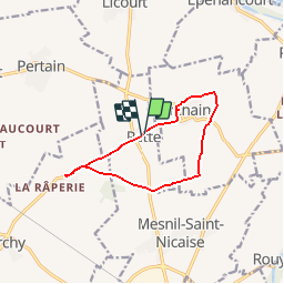
11.5 km | 12.4 km-effort
2h 50min
Yes
Trail Walking Pargny - Circuit du Clos Bouteille -  Pargny - Photo
Walking
tracegps

Walking

Medium
Pargny, Hauts-de-France, Somme, France
10.7 km | 11.5 km-effort
2h 0min
Yes
Trail Walking Curchy - Circuit de l'Ingon - Curchy - Photo
Walking
tracegps

Walking

Medium
Curchy, Hauts-de-France, Somme, France
9.7 km | 10.7 km-effort
2h 30min
Yes
Trail Walking Pargny - Circuit du Fief Doré - Pargny - Photo
Walking
tracegps

Walking

Medium
Pargny, Hauts-de-France, Somme, France
10.7 km | 11.5 km-effort
2h 40min
Yes
Trail Walking Nesle - Circuit de la fontaine Saint Quentin - Nesle - Photo
Walking
tracegps

Walking

Medium
Nesle, Hauts-de-France, Somme, France
12.5 km | 13.8 km-effort
3h 10min
Yes
Trail Walking Hypercourt - Circuit du bois de Meurdris -  Pertain - Photo
Walking
tracegps

Walking

Medium
Hypercourt, Hauts-de-France, Somme, France
12.9 km | 13.8 km-effort
3h 15min
Yes
Trail Cycle Nesle - Canal du Nord et de la Somme - Photo
Cycle
tracegps

Cycle

Medium
(1)
Nesle, Hauts-de-France, Somme, France
41 km | 45 km-effort
2h 30min
Yes
Trail Walking Mesnil-Saint-Nicaise - randonnée de la fête du sport  - Photo
Walking
José800

Walking

Easy
Mesnil-Saint-Nicaise, Hauts-de-France, Somme, France
9.9 km | 10.8 km-effort
2h 4min
Yes
Trail Walking Pargny - le clos bouteille - Photo
Walking
José800

Walking

Medium
Pargny, Hauts-de-France, Somme, France
9.5 km | 10.3 km-effort
2h 49min
Yes


Close
My subscriptions