Trail Walking Bitschwiller-lès-Thann - REHBRUNNEL - Photo
© OpenStreetMap contributors
Length
Length
8.2 km
Max alt
Max alt
826 m
Uphill gradient
Uphill gradient
402 m
Km-Effort
Km-Effort  
13.6 km
Min alt
Min alt
421 m
Downhill gradient
Downhill gradient
402 m
Boucle
Boucle
Yes
Creation date :
2018-10-13 05:53:47.641
Updated on :
2018-10-13 05:53:47.648

(0 Reviews)

Walking
Walking
--
Difficulty : Medium

Scan this QR Code to open this trail in the SityTrail application

FREE GPS app for hiking

Logo SityTrail SityTrail

IGN / Geographical institutes

Download SityTrail from the App Store Download SityTrail from Google Play

Logo SityTrail SityTrail World

The world is yours!

Download SityTrail from the App Store Download SityTrail from Google Play Download SityTrail on Huawei AppGallery

About

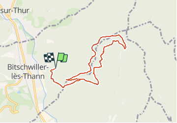
Trail Walking of 8.2 km to be discovered at Grand Est, Haut-Rhin, Bitschwiller-lès-Thann. This trail is proposed by patrickbeyrath.

Description

Départ au bout de rue des Vignes à Bittschwiller les Thann et prendre rect.rouge blanc rouge Grumbachkopf et rect.rougeCamps des Pyramides, circuit bleu Rehbrunnel,croix jauneCol de Grumbachet rect. rouge blanc rouge pour le retour Bittschwiller environ 10km

Elevation profile

Positioning

Country:
France
Region :
Grand Est
Department/Province :
Haut-Rhin
Municipality :
Bitschwiller-lès-Thann
Location:
Unknown
Start:(UTM)
356976 ; 5299166 (32T) N.

Trails nearby

Trail Walking Soultz-Haut-Rhin - Hartmannswillerkopf - Circuit découverte - Photo
Walking
VacheKiri67

Walking

Easy
(1)
Soultz-Haut-Rhin, Grand Est, Haut-Rhin, France
3.6 km | 5.2 km-effort
1h 46min
Yes
Trail Walking Soultz-Haut-Rhin - Hartmannswillerkopf - Circuit anneau bleu - Photo
Walking
VacheKiri67

Walking

Medium
(1)
Soultz-Haut-Rhin, Grand Est, Haut-Rhin, France
3.7 km | 5.9 km-effort
1h 37min
Yes
Trail Other activity Steinbach - lac du ballon - Photo
Other activity
rodabruna

Other activity

Very easy
(1)
Steinbach, Grand Est, Haut-Rhin, France
33 km | 64 km-effort
5h 1min
No
Trail Walking Bourbach-le-Haut - 2024-01-12_14h17m14_239006910 - Photo
Walking
GUIDE
mumu.larandonneuse

Walking

Difficult
Bourbach-le-Haut, Grand Est, Haut-Rhin, France
11.4 km | 18.5 km-effort
4h 12min
Yes
Trail Trail Wattwiller - The History Ultra - stage 1 - Photo
Trail
Olivier Houette

Trail

Very easy
(1)
Wattwiller, Grand Est, Haut-Rhin, France
28 km | 48 km-effort
Unknown
No
Trail Walking Thann - SityTrail - 2489713 - thann-roche--albert--grumbachkopf - Photo
Walking
argonneuweg

Walking

Medium
(1)
Thann, Grand Est, Haut-Rhin, France
7.6 km | 12 km-effort
2h 28min
Yes
Trail On foot Bitschwiller-lès-Thann - Bitschwiller les Thann - Rehbrunnel - Abri du Becherkopf - Roche Albert - Photo
On foot
patrickbeyrath

On foot

Medium
(1)
Bitschwiller-lès-Thann, Grand Est, Haut-Rhin, France
10.3 km | 16.4 km-effort
Unknown
Yes
Trail Walking Bitschwiller-lès-Thann - 68 Col du Hundsrück  - FA Gsang - retour ThannerHubel - Photo
Walking

Walking

Medium
(1)
Bitschwiller-lès-Thann, Grand Est, Haut-Rhin, France
11.2 km | 18.4 km-effort
3h 48min
Yes
Trail Walking Steinbach - Rando Marcheurs du 03/07/2023 par ALAIN - Photo
Walking
boubou68

Walking

Very difficult
Steinbach, Grand Est, Haut-Rhin, France
20 km | 34 km-effort
5h 1min
Yes


Close
My subscriptions