Trail Mountain bike Argelès-Gazost - autour d'argeles - Photo
 harydh
harydh

User GUIDE

© OpenStreetMap contributors
Length
Length
20 km
Max alt
Max alt
646 m
Uphill gradient
Uphill gradient
457 m
Km-Effort
Km-Effort  
26 km
Min alt
Min alt
396 m
Downhill gradient
Downhill gradient
459 m
Boucle
Boucle
Yes
Creation date :
2014-12-10 00:00:00.0
Updated on :
2014-12-10 00:00:00.0

(0 Reviews)

Mountain bike
Mountain bike
--
Difficulty : Easy

Scan this QR Code to open this trail in the SityTrail application

FREE GPS app for hiking

Logo SityTrail SityTrail

IGN / Geographical institutes

Download SityTrail from the App Store Download SityTrail from Google Play

Logo SityTrail SityTrail World

The world is yours!

Download SityTrail from the App Store Download SityTrail from Google Play Download SityTrail on Huawei AppGallery

About

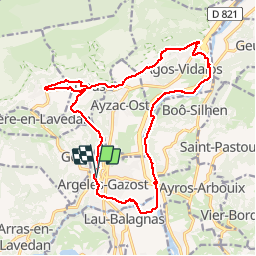
Trail Mountain bike of 20 km to be discovered at Occitania, Hautespyrenees, Argelès-Gazost. This trail is proposed by harydh.

Description

bucolique ,varié et apaisant
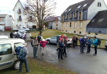
Elevation profile

Points of interest

Point of interest Argelès-Gazost - Start - Photo
harydh
ARGELÈS-GAZOST 
Point of interest Argelès-Gazost - Lap 1 - Photo
harydh
ARGELÈS-GAZOST 

Positioning

Country:
France
Region :
Occitania
Department/Province :
Hautespyrenees
Municipality :
Argelès-Gazost
Location:
Unknown
Start:(UTM)
736206 ; 4765641 (30T) N.

Trails nearby

Trail Walking Arcizans-Dessus - la fontaine de Nabias - Photo
Walking
bernardbelmas

Walking

Very easy
(1)
Arcizans-Dessus, Occitania, Hautespyrenees, France
4.2 km | 6.8 km-effort
1h 40min
Yes
Trail Walking Argelès-Gazost - Le Mont de Gez en circuit - Argelès Gazost - Photo
Walking
tracegps

Walking

Medium
(1)
Argelès-Gazost, Occitania, Hautespyrenees, France
11.8 km | 20 km-effort
4h 30min
Yes
Trail Electric bike Argelès-Gazost - CABALIROS 30 JUIN 2023 - Photo
Electric bike
GUIDE
harydh

Electric bike

Medium
Argelès-Gazost, Occitania, Hautespyrenees, France
39 km | 57 km-effort
4h 47min
Yes
Trail Walking Argelès-Gazost - ARGELES La boucle de l arrieulat - Photo
Walking
GUIDE
marmotte65

Walking

Difficult
Argelès-Gazost, Occitania, Hautespyrenees, France
10.3 km | 14.6 km-effort
3h 4min
Yes
Trail Walking Adast - PIERREFITTE le lac des gaves - Photo
Walking
GUIDE
marmotte65

Walking

Very easy
Adast, Occitania, Hautespyrenees, France
6.2 km | 6.7 km-effort
1h 51min
Yes
Trail Walking Argelès-Gazost - ARGELES-GAZOST chateau et lac d'Arcizans depuis l'Arieulat  faitG - Photo
Walking
GUIDE
marmotte65

Walking

Easy
Argelès-Gazost, Occitania, Hautespyrenees, France
7.9 km | 11.8 km-effort
4h 56min
Yes
Trail Walking Argelès-Gazost - ARGELES Mont de Gez G3 fait - Photo
Walking
GUIDE
marmotte65

Walking

Medium
Argelès-Gazost, Occitania, Hautespyrenees, France
10.2 km | 18.3 km-effort
5h 39min
Yes
Trail Walking Ouzous - Ouzous pibeste-fait - Photo
Walking

Walking

Medium
(1)
Ouzous, Occitania, Hautespyrenees, France
11.3 km | 22 km-effort
4h 29min
Yes
Trail Walking Ouzous - Pic du Pibeste  - Photo
Walking
DuMarsan

Walking

Medium
(1)
Ouzous, Occitania, Hautespyrenees, France
13 km | 25 km-effort
6h 9min
Yes


Close
My subscriptions