Trail Walking Brousse-le-Château - Brousse Le Chateau et les alentours - Photo

Brousse Le Chateau et les alentours

© OpenStreetMap contributors
Length
Length
18.4 km
Max alt
Max alt
518 m
Uphill gradient
Uphill gradient
658 m
Km-Effort
Km-Effort  
27 km
Min alt
Min alt
230 m
Downhill gradient
Downhill gradient
661 m
Boucle
Boucle
Yes
Creation date :
2014-12-10 00:00:00.0
Updated on :
2014-12-10 00:00:00.0

(1 Reviews)

Walking
Walking
4h54
Difficulty : Medium

Scan this QR Code to open this trail in the SityTrail application

FREE GPS app for hiking

Logo SityTrail SityTrail

IGN / Geographical institutes

Download SityTrail from the App Store Download SityTrail from Google Play

Logo SityTrail SityTrail World

The world is yours!

Download SityTrail from the App Store Download SityTrail from Google Play Download SityTrail on Huawei AppGallery

About

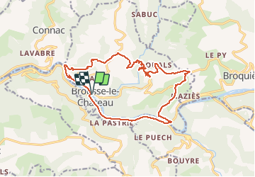
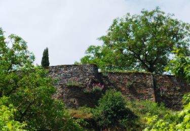
Trail Walking of 18.4 km to be discovered at Occitania, Aveyron, Brousse-le-Château. This trail is proposed by romananus1er.

Description

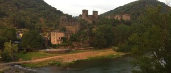
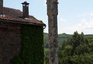
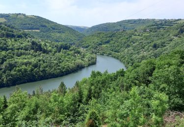
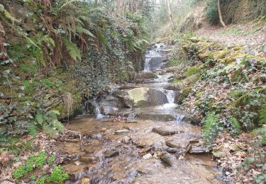
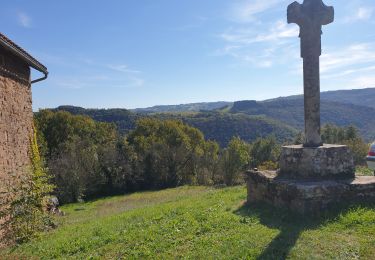
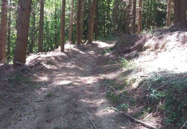
Le départ de la randonnée s’effectue depuis le parking de Brousse le Château, l’un des plus beau village de France. Prendre la D143 vers l’Ouest jusqu’au départ d’un chemin de terre en contrebas. Descendre le long du chemin et deux virages vous amènent sur les berges du Tarn. Longez les champs se trouvant sur votre droite et prendre le premier chemin sur la droite. Au bout de 100 mètres, un sentier de randonnée sur votre droite vous obligera à traverser un ruisseau. La phase de grimpette commence alors. Au croisement d’un grand chemin forestier, prendre à gauche pour remonter jusqu’au hameau de Layrolle. Prendre la  route vers la gauche pour passer Le Cluzel. Au prochain croisement de route, prendre sur votre gauche, direction Saint Martin. Au prochain carrefour, suivre le balisage jaune qui vous emmènera jusqu’à l’église qu’il faudra contourner par la gauche. Après le cimetière, prendre la route vers la droite jusqu’au hameau La Castié. Attention, au hameau, prendre de suite à droite et longer les magnifiques maisons de pierre. Continuer dans le hameau jusqu’au bout de la partie goudronnée pour trouver un sentier. Celui-ci vous emmènera au fond de la vallée où coule l’Alrance, pour après remonter sur le flan opposé.

Elevation profile

Photos

Points of interest

Point of interest Brousse-le-Château - Point 2 - Photo
romananus1er
BROUSSE-LE-CHÂTEAU 
Point of interest Brousse-le-Château - Arrivée à Brousse - Photo
romananus1er
BROUSSE-LE-CHÂTEAU 

Positioning

Country:
France
Region :
Occitania
Department/Province :
Aveyron
Municipality :
Brousse-le-Château
Location:
Unknown
Start:(UTM)
469792 ; 4871700 (31T) N.

Comments

Please log in to post a review or rate the element


Trails nearby

Trail Walking Brousse-le-Château - Brousse  st martin - Photo
Walking
nanie

Walking

Difficult
Brousse-le-Château, Occitania, Aveyron, France
8.5 km | 12.9 km-effort
2h 55min
Yes
Trail Walking Brousse-le-Château - J12:Brousse le Château-Villeneuve sur Tarn-200522 - Photo
Walking
canardDenis

Walking

Medium
Brousse-le-Château, Occitania, Aveyron, France
23 km | 31 km-effort
7h 2min
No
Trail Walking Coupiac - coupiac in live - Photo
Walking
CASSISFRAMBOISE

Walking

Medium
Coupiac, Occitania, Aveyron, France
18.9 km | 27 km-effort
4h 31min
Yes
Trail Walking Brousse-le-Château - brousse le chateau - Photo
Walking
CASSISFRAMBOISE

Walking

Medium
Brousse-le-Château, Occitania, Aveyron, France
16.5 km | 24 km-effort
4h 28min
Yes
Trail Walking Connac - Boucle Connac Lincou - Photo
Walking
tercla

Walking

Difficult
Connac, Occitania, Aveyron, France
20 km | 29 km-effort
7h 8min
Yes
Trail Walking Réquista - Lincou - Cannac  2024 - Photo
Walking
Frayssinet

Walking

Very difficult
Réquista, Occitania, Aveyron, France
22 km | 32 km-effort
7h 19min
Yes
Trail Walking Brousse-le-Château - randonnée de castel brousse le château  - Photo
Walking
Pascal Lemaire

Walking

Medium
Brousse-le-Château, Occitania, Aveyron, France
8.1 km | 12.6 km-effort
2h 38min
Yes
Trail Walking Montclar - saint igest  - Photo
Walking
Frayssinet

Walking

Medium
Montclar, Occitania, Aveyron, France
25 km | 39 km-effort
9h 34min
Yes
Trail Walking Connac - connac - Photo
Walking
yvesmonteillet

Walking

Very difficult
Connac, Occitania, Aveyron, France
15.3 km | 23 km-effort
6h 21min
Yes


Close
My subscriptions