Trail Mountain bike Perthes - perthes signy l'abbaye - Photo

perthes signy l'abbaye

 8pascal8
8pascal8

User

© OpenStreetMap contributors
Length
Length
44 km
Max alt
Max alt
222 m
Uphill gradient
Uphill gradient
663 m
Km-Effort
Km-Effort  
53 km
Min alt
Min alt
66 m
Downhill gradient
Downhill gradient
637 m
Boucle
Boucle
No
Creation date :
2014-12-10 00:00:00.0
Updated on :
2014-12-10 00:00:00.0

(0 Reviews)

Mountain bike
Mountain bike
--
Difficulty : Unknown

Scan this QR Code to open this trail in the SityTrail application

FREE GPS app for hiking

Logo SityTrail SityTrail

IGN / Geographical institutes

Download SityTrail from the App Store Download SityTrail from Google Play

Logo SityTrail SityTrail World

The world is yours!

Download SityTrail from the App Store Download SityTrail from Google Play Download SityTrail on Huawei AppGallery

About

Trail Mountain bike of 44 km to be discovered at Grand Est, Ardennes, Perthes. This trail is proposed by 8pascal8.

Description

De perthes à signy l'abbaye en passant par le GR12

Elevation profile

Positioning

Country:
France
Region :
Grand Est
Department/Province :
Ardennes
Municipality :
Perthes
Location:
Unknown
Start:(UTM)
597961 ; 5478362 (31U) N.

Trails nearby

Trail Walking Neuflize - Parcours de Lagein - Neuflize - Photo
Walking
tracegps

Walking

Medium
Neuflize, Grand Est, Ardennes, France
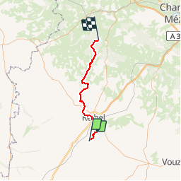
9.3 km | 10.9 km-effort
2h 19min
Yes
Trail Walking Neuflize - Le long de la Retourne - Neuflize - Photo
Walking
tracegps

Walking

Medium
Neuflize, Grand Est, Ardennes, France
8.7 km | 9.8 km-effort
2h 10min
Yes


Close
My subscriptions