Trail Walking La Chapelle-d'Abondance - Gr5-Etape 3 - Photo
© OpenStreetMap contributors
Length
Length
13.7 km
Max alt
Max alt
1999 m
Uphill gradient
Uphill gradient
659 m
Km-Effort
Km-Effort  
22 km
Min alt
Min alt
1663 m
Downhill gradient
Downhill gradient
545 m
Boucle
Boucle
No
Creation date :
2014-12-10 00:00:00.0
Updated on :
2014-12-10 00:00:00.0

(1 Reviews)

Walking
Walking
4h38
Difficulty : Unknown

Scan this QR Code to open this trail in the SityTrail application

FREE GPS app for hiking

Logo SityTrail SityTrail

IGN / Geographical institutes

Download SityTrail from the App Store Download SityTrail from Google Play

Logo SityTrail SityTrail World

The world is yours!

Download SityTrail from the App Store Download SityTrail from Google Play Download SityTrail on Huawei AppGallery

About

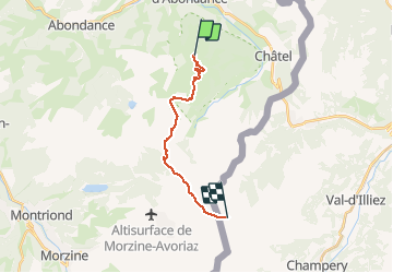
Trail Walking of 13.7 km to be discovered at Auvergne-Rhône-Alpes, Upper Savoy, La Chapelle-d'Abondance. This trail is proposed by Gratouille.

Description

Gr5 étape 3 Gite de Trébentaz - refuge de Chésery

Elevation profile

Positioning

Country:
France
Region :
Auvergne-Rhône-Alpes
Department/Province :
Upper Savoy
Municipality :
La Chapelle-d'Abondance
Location:
Unknown
Start:(UTM)
329850 ; 5126133 (32T) N.

Comments

Please log in to post a review or rate the element


Trails nearby

Trail Walking Châtel - Mont de grange depuis le col de Bassachaux  - Photo
Walking
dalla.anthony

Walking

Difficult
(2)
Châtel, Auvergne-Rhône-Alpes, Upper Savoy, France
16.5 km | 30 km-effort
6h 7min
Yes
Trail Walking La Chapelle-d'Abondance - Le Linleu 2093 m, depuis Sevan-devant - Photo
Walking
tracegps

Walking

Medium
(1)
La Chapelle-d'Abondance, Auvergne-Rhône-Alpes, Upper Savoy, France
5.1 km | 11.9 km-effort
3h 0min
Yes
Trail Walking Abondance - Le Mont de Grange, 2432m - Photo
Walking
tracegps

Walking

Difficult
(1)
Abondance, Auvergne-Rhône-Alpes, Upper Savoy, France
10.9 km | 25 km-effort
7h 0min
Yes
Trail Walking La Chapelle-d'Abondance - Les Cornettes de Bise par le sentier de Saix Rouquin - Photo
Walking
tracegps

Walking

Difficult
(1)
La Chapelle-d'Abondance, Auvergne-Rhône-Alpes, Upper Savoy, France
10 km | 25 km-effort
6h 30min
Yes
Trail Walking La Chapelle-d'Abondance - Cascade boucle 2 - Photo
Walking
Derrendinger

Walking

Difficult
(1)
La Chapelle-d'Abondance, Auvergne-Rhône-Alpes, Upper Savoy, France
10.1 km | 14.9 km-effort
3h 23min
Yes
Trail Snowshoes Châtel - Petite  Châtel - Photo
Snowshoes
GUIDE
pascalou73

Snowshoes

Medium
Châtel, Auvergne-Rhône-Alpes, Upper Savoy, France
5.7 km | 10.6 km-effort
2h 0min
Yes
Trail Snowshoes Châtel - Randonnée entre la France et la suisse  - Photo
Snowshoes
GUIDE
pascalou73

Snowshoes

Easy
Châtel, Auvergne-Rhône-Alpes, Upper Savoy, France
5.8 km | 8.5 km-effort
2h 3min
Yes
Trail Walking Vacheresse - Tour du Mont Chauffé  - Photo
Walking
reneperrin

Walking

Medium
Vacheresse, Auvergne-Rhône-Alpes, Upper Savoy, France
12.7 km | 23 km-effort
5h 12min
Yes
Trail Walking Vacheresse - Ubine, col d'Ubine, col des Mosses, chalets de Bise, lac de Fontaine - Photo
Walking
reneperrin

Walking

Medium
Vacheresse, Auvergne-Rhône-Alpes, Upper Savoy, France
8.6 km | 15.6 km-effort
6h 13min
No


Close
My subscriptions