Trail Mountain bike Ver-sur-Launette - rando foret d'ermenonville-3 etangs - Photo

rando foret d'ermenonville-3 etangs

 lafleur
lafleur

User

© OpenStreetMap contributors
Length
Length
18.9 km
Max alt
Max alt
127 m
Uphill gradient
Uphill gradient
216 m
Km-Effort
Km-Effort  
22 km
Min alt
Min alt
76 m
Downhill gradient
Downhill gradient
217 m
Boucle
Boucle
Yes
Creation date :
2014-12-10 00:00:00.0
Updated on :
2014-12-10 00:00:00.0

(0 Reviews)

Mountain bike
Mountain bike
--
Difficulty : Unknown

Scan this QR Code to open this trail in the SityTrail application

FREE GPS app for hiking

Logo SityTrail SityTrail

IGN / Geographical institutes

Download SityTrail from the App Store Download SityTrail from Google Play

Logo SityTrail SityTrail World

The world is yours!

Download SityTrail from the App Store Download SityTrail from Google Play Download SityTrail on Huawei AppGallery

About

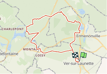
Trail Mountain bike of 18.9 km to be discovered at Hauts-de-France, Oise, Ver-sur-Launette. This trail is proposed by lafleur.

Description

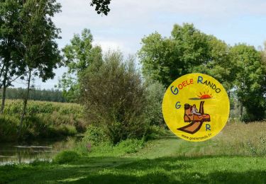
une visite de plusieurs etangs

Elevation profile

Points of interest

Point of interest Fontaine-Chaalis - etang de la ramee - Photo
lafleur
FONTAINE-CHAALIS 
Point of interest Fontaine-Chaalis - etang de l epine - Photo
lafleur
FONTAINE-CHAALIS 
Point of interest Ermenonville - eatng du dessert - Photo
lafleur
ERMENONVILLE 
Point of interest Fontaine-Chaalis - aire de pique nique - Photo
lafleur
FONTAINE-CHAALIS 

Positioning

Country:
France
Region :
Hauts-de-France
Department/Province :
Oise
Municipality :
Ver-sur-Launette
Location:
Unknown
Start:(UTM)
477021 ; 5439330 (31U) N.

Trails nearby

Trail Walking Ermenonville - SM_ERMENONVILLE CHATEAU_NORD_8.1Km - Photo
Walking
GR77LP

Walking

Easy
(1)
Ermenonville, Hauts-de-France, Oise, France
8.1 km | 9.5 km-effort
2h 12min
Yes
Trail Walking Fontaine-Chaalis - Abbaye de Chaalis+fiche+GPX_ 7,8Km_SM - Photo
Walking

Walking

Medium
(7)
Fontaine-Chaalis, Hauts-de-France, Oise, France
7.9 km | 9 km-effort
2h 2min
Yes
Trail Walking Ver-sur-Launette - SM_VER-sur-LAUNETTE_8.5Km - Photo
Walking
GR77LP

Walking

Medium
(7)
Ver-sur-Launette, Hauts-de-France, Oise, France
8.5 km | 9.6 km-effort
2h 6min
Yes
Trail Walking Fontaine-Chaalis - Abbaye de Chaalis Supermini Rando - Photo
Walking

Walking

Medium
(6)
Fontaine-Chaalis, Hauts-de-France, Oise, France
8.5 km | 9.5 km-effort
1h 56min
Yes
Trail Walking Ermenonville - Ermenonville Chateau 6,3 Km - Photo
Walking
GR77LP

Walking

Medium
(4)
Ermenonville, Hauts-de-France, Oise, France
5.8 km | 6.8 km-effort
1h 32min
Yes
Trail Walking Montagny-Sainte-Félicité - SM_MONTAGNY_Ste-FELECITE_8.5Km - Photo
Walking
GR77LP

Walking

Medium
(6)
Montagny-Sainte-Félicité, Hauts-de-France, Oise, France
8.6 km | 10.1 km-effort
2h 12min
Yes
Trail Walking Ver-sur-Launette - SM_LOISY_8.5Km - Photo
Walking
GR77LP

Walking

Medium
(2)
Ver-sur-Launette, Hauts-de-France, Oise, France
8.7 km | 9.7 km-effort
2h 12min
Yes
Trail Walking Othis - SM_BEAUMARCHAIS_8.2Km - Photo
Walking
GR77LP

Walking

Medium
(4)
Othis, Ile-de-France, Seine-et-Marne, France
8.3 km | 9.1 km-effort
2h 3min
Yes
Trail Walking Fontaine-Chaalis - MR_ERMENONVILLE-Maison-Blanche_5.8Km - Photo
Walking
GR77LP

Walking

Medium
(1)
Fontaine-Chaalis, Hauts-de-France, Oise, France
5.8 km | 6.6 km-effort
1h 30min
Yes


Close
My subscriptions