Trail Snowshoes Ceillac - Queyras Cols Bramousse et du Fromage.gpx - Photo

Queyras Cols Bramousse et du Fromage.gpx

 phidge
phidge

User

© OpenStreetMap contributors
Length
Length
14.1 km
Max alt
Max alt
2339 m
Uphill gradient
Uphill gradient
1182 m
Km-Effort
Km-Effort  
30 km
Min alt
Min alt
1670 m
Downhill gradient
Downhill gradient
1187 m
Boucle
Boucle
Yes
Creation date :
2019-01-20 16:38:07.467
Updated on :
2019-01-20 16:38:07.485

(0 Reviews)

Snowshoes
Snowshoes
5m
Difficulty : Unknown

Scan this QR Code to open this trail in the SityTrail application

FREE GPS app for hiking

Logo SityTrail SityTrail

IGN / Geographical institutes

Download SityTrail from the App Store Download SityTrail from Google Play

Logo SityTrail SityTrail World

The world is yours!

Download SityTrail from the App Store Download SityTrail from Google Play Download SityTrail on Huawei AppGallery

About

Trail Snowshoes of 14.1 km to be discovered at Provence-Alpes-Côte d'Azur, Hautes-Alpes, Ceillac. This trail is proposed by phidge.

Elevation profile

Positioning

Country:
France
Region :
Provence-Alpes-Côte d'Azur
Department/Province :
Hautes-Alpes
Municipality :
Ceillac
Location:
Unknown
Start:(UTM)
323756 ; 4948851 (32T) N.

Trails nearby

Trail Walking Ceillac - Crêtes de Chambrettes - Photo
Walking
GUIDE
amiral13

Walking

Medium
(1)
Ceillac, Provence-Alpes-Côte d'Azur, Hautes-Alpes, France
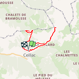
13.4 km | 26 km-effort
5h 53min
Yes
Trail Walking Ceillac - 05 Tour Font Sancte - étape 1 - Photo
Walking
Maryma

Walking

Very difficult
(1)
Ceillac, Provence-Alpes-Côte d'Azur, Hautes-Alpes, France
16.5 km | 36 km-effort
8h 9min
No
Trail Walking Ceillac - Ceillac - St Véran - Photo
Walking
GUIDE
romanceline

Walking

Medium
Ceillac, Provence-Alpes-Côte d'Azur, Hautes-Alpes, France
13.5 km | 28 km-effort
7h 22min
No
Trail Walking Ceillac - la pointe de la Saume (traversée) - Photo
Walking
GUIDE
amiral13

Walking

Difficult
Ceillac, Provence-Alpes-Côte d'Azur, Hautes-Alpes, France
15 km | 34 km-effort
6h 43min
No
Trail Walking Ceillac - Lac Ste Anne et Tête de Girardin - Photo
Walking
GUIDE
amiral13

Walking

Medium
Ceillac, Provence-Alpes-Côte d'Azur, Hautes-Alpes, France
14.4 km | 27 km-effort
5h 48min
Yes
Trail Walking Ceillac - lac Sainte Anne - Photo
Walking
griffet

Walking

Easy
(2)
Ceillac, Provence-Alpes-Côte d'Azur, Hautes-Alpes, France
10.7 km | 17.9 km-effort
5h 16min
No
Trail Walking Ceillac - #1 Queyras 3j étape 1 Ceillac - Lac de Roue - Photo
Walking
Liobric

Walking

Very difficult
Ceillac, Provence-Alpes-Côte d'Azur, Hautes-Alpes, France
16.7 km | 33 km-effort
7h 34min
No
Trail Walking Ceillac - Arvieux Randonnée - Photo
Walking
choumac08

Walking

Very difficult
Ceillac, Provence-Alpes-Côte d'Azur, Hautes-Alpes, France
138 km | 250 km-effort
56h 55min
Yes
Trail Walking Ceillac - circuit des fours à chaux - Photo
Walking
marchev

Walking

Easy
Ceillac, Provence-Alpes-Côte d'Azur, Hautes-Alpes, France
7 km | 9.3 km-effort
2h 27min
No


Close
My subscriptions