Trail Cycle Lieusaint - Vélofolies 2012 - Photo
 durmord
durmord

User

© OpenStreetMap contributors
Length
Length
43 km
Max alt
Max alt
99 m
Uphill gradient
Uphill gradient
226 m
Km-Effort
Km-Effort  
46 km
Min alt
Min alt
73 m
Downhill gradient
Downhill gradient
226 m
Boucle
Boucle
Yes
Creation date :
2019-04-28 13:04:30.586
Updated on :
2019-04-28 13:04:30.703

(0 Reviews)

Cycle
Cycle
--
Difficulty : Easy

Scan this QR Code to open this trail in the SityTrail application

FREE GPS app for hiking

Logo SityTrail SityTrail

IGN / Geographical institutes

Download SityTrail from the App Store Download SityTrail from Google Play

Logo SityTrail SityTrail World

The world is yours!

Download SityTrail from the App Store Download SityTrail from Google Play Download SityTrail on Huawei AppGallery

About

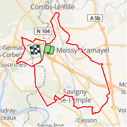
Trail Cycle of 43 km to be discovered at Ile-de-France, Seine-et-Marne, Lieusaint. This trail is proposed by durmord.

Description

Correction suite à la reconnaissance du 16/09/2012

Elevation profile

Points of interest

Point of interest Saint-Pierre-du-Perray - Départ Peloton N°2 - Photo
durmord
SAINT-PIERRE-DU-PERRAY 
Point of interest Lieusaint - Départ peloton N°1 - Photo
durmord
Point of interest Moissy-Cramayel - Départ Vélos peloton n°3 - Photo
durmord
Point of interest Vert-Saint-Denis - Départ du peloton n°4 - Photo
durmord
VERT-SAINT-DENIS 

Positioning

Country:
France
Region :
Ile-de-France
Department/Province :
Seine-et-Marne
Municipality :
Lieusaint
Location:
Unknown
Start:(UTM)
466099 ; 5384961 (31U) N.

Trails nearby

Trail Walking Savigny-le-Temple - Entre Savigny-le-Temple et Seine-Port - Photo
Walking
DUGAEL

Walking

Very easy
(1)
Savigny-le-Temple, Ile-de-France, Seine-et-Marne, France
11 km | 12.8 km-effort
2h 59min
No
Trail On foot Tigery - L 23 Lieusaint, ruisseau des Heauldres, canal d'Ormoy - Photo
On foot

On foot

Very easy
(3)
Tigery, Ile-de-France, Essonne, France
5.1 km | 5.4 km-effort
1h 14min
Yes
Trail Walking Tigery - Ru des Hauldres - Photo
Walking
GUIDE
jeanmarcMasson

Walking

Medium
(1)
Tigery, Ile-de-France, Essonne, France
8.7 km | 9.3 km-effort
2h 7min
Yes
Trail Walking Étiolles - Arbres remarquables des chasses royales de Sénart - Photo
Walking

Walking

Difficult
(2)
Étiolles, Ile-de-France, Essonne, France
23 km | 25 km-effort
5h 46min
Yes
Trail Walking Nandy - 2017-10-05-Cesson - Photo
Walking

Walking

Difficult
(1)
Nandy, Ile-de-France, Seine-et-Marne, France
21 km | 24 km-effort
5h 32min
Yes
Trail On foot Saint-Pierre-du-Perray - 2020-10-20_05h12m58_R2iIxMbsAX0 - Photo
On foot

On foot

Very easy
(1)
Saint-Pierre-du-Perray, Ile-de-France, Essonne, France
7.3 km | 7.9 km-effort
1h 47min
Yes
Trail On foot Combs-la-Ville - L 21 5.6 km Parcours santé Combs la Ville et forêt de Sénart - Photo
On foot

On foot

Very easy
(2)
Combs-la-Ville, Ile-de-France, Seine-et-Marne, France
5.6 km | 6.2 km-effort
1h 18min
Yes
Trail Walking Tigery - J 17 -  11.34 km - Boucle du pont du roi( tigery) à Moissy-Cramayel et retour  - Photo
Walking

Walking

Medium
(4)
Tigery, Ile-de-France, Essonne, France
11.5 km | 12.4 km-effort
2h 46min
Yes
Trail Walking Morsang-sur-Seine - Morsang-sur-Seine_22km - Photo
Walking
Martial LHUILLERY

Walking

Medium
(1)
Morsang-sur-Seine, Ile-de-France, Essonne, France
22 km | 26 km-effort
4h 11min
Yes


Close
My subscriptions