Trail Walking Sainte-Foy-lès-Lyon - Sentier Aqueduc Ste Foy-Chaponost - Photo
© OpenStreetMap contributors
Length
Length
17.4 km
Max alt
Max alt
333 m
Uphill gradient
Uphill gradient
394 m
Km-Effort
Km-Effort  
23 km
Min alt
Min alt
177 m
Downhill gradient
Downhill gradient
394 m
Boucle
Boucle
Yes
Creation date :
2019-03-09 18:48:15.356
Updated on :
2019-03-09 18:48:15.383

(0 Reviews)

Walking
Walking
4h08
Difficulty : Medium

Scan this QR Code to open this trail in the SityTrail application

FREE GPS app for hiking

Logo SityTrail SityTrail

IGN / Geographical institutes

Download SityTrail from the App Store Download SityTrail from Google Play

Logo SityTrail SityTrail World

The world is yours!

Download SityTrail from the App Store Download SityTrail from Google Play Download SityTrail on Huawei AppGallery

About

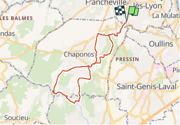
Trail Walking of 17.4 km to be discovered at Auvergne-Rhône-Alpes, Métropole de Lyon, Sainte-Foy-lès-Lyon. This trail is proposed by Bobosse69.

Description

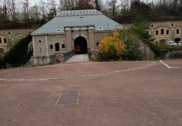
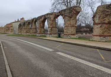
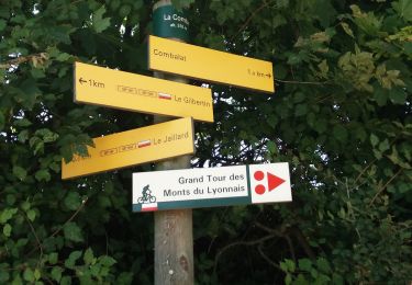
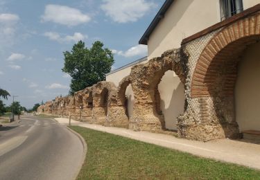
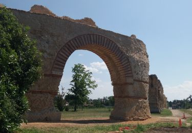
Départ et arrivée Parking Aqueduc de Beaunant à côté du Garage Opel
Sens Chantegrillet-la Chaize-Cote de l'air-l'Orme-le Plat de l'air          

Elevation profile

Positioning

Country:
France
Region :
Auvergne-Rhône-Alpes
Department/Province :
Métropole de Lyon
Municipality :
Sainte-Foy-lès-Lyon
Location:
Unknown
Start:(UTM)
638437 ; 5065164 (31T) N.

Comments

Please log in to post a review or rate the element


Trails nearby

Trail Walking Craponne - départ cimetière de Craponne - Photo
Walking
mimi69670

Walking

Easy
(1)
Craponne, Auvergne-Rhône-Alpes, Métropole de Lyon, France
10.3 km | 13.1 km-effort
2h 36min
Yes
Trail Mountain bike Lyon - Mont Verdun - Photo
Mountain bike
tracegps

Mountain bike

Difficult
(2)
Lyon, Auvergne-Rhône-Alpes, Métropole de Lyon, France
29 km | 37 km-effort
2h 15min
Yes
Trail Walking Lyon - De Place des Archives à Monplaisir - Photo
Walking
Marie-Hélène Luton 2

Walking

Difficult
(1)
Lyon, Auvergne-Rhône-Alpes, Métropole de Lyon, France
11.2 km | 12.9 km-effort
2h 55min
No
Trail Walking Francheville - Aqueduc et fort du Bruissin (PR1) - Photo
Walking
chuck

Walking

Easy
Francheville, Auvergne-Rhône-Alpes, Métropole de Lyon, France
19.1 km | 23 km-effort
5h 20min
Yes
Trail Walking Craponne - de Craponne à Brindas .  - Photo
Walking
maclobar

Walking

Medium
Craponne, Auvergne-Rhône-Alpes, Métropole de Lyon, France
9.5 km | 11.5 km-effort
2h 8min
Yes
Trail Walking Chaponost - de Chaponost à Brignais AR - Photo
Walking
maclobar

Walking

Difficult
Chaponost, Auvergne-Rhône-Alpes, Rhône, France
11.8 km | 14.3 km-effort
2h 40min
Yes
Trail Walking Chaponost - Chaponost boucle - Photo
Walking
maclobar

Walking

Medium
Chaponost, Auvergne-Rhône-Alpes, Rhône, France
9.2 km | 11.2 km-effort
1h 56min
Yes
Trail Walking Chaponost - Acqueducs de Chaponost à Beaunant - Photo
Walking
maclobar

Walking

Medium
Chaponost, Auvergne-Rhône-Alpes, Rhône, France
7 km | 9.2 km-effort
1h 35min
Yes
Trail Walking Sainte-Foy-lès-Lyon - Sainte foy les lyon - Photo
Walking
daniellebou

Walking

Difficult
(1)
Sainte-Foy-lès-Lyon, Auvergne-Rhône-Alpes, Métropole de Lyon, France
9.9 km | 13.2 km-effort
2h 52min
Yes


Close
My subscriptions