Trail Walking Courcelles-sur-Seine - Courcelles-sur-Seine - Entre étangs et sablières - Photo

Courcelles-sur-Seine - Entre étangs et sablières

 marcel.F
marcel.F

User

© OpenStreetMap contributors
Length
Length
12.7 km
Max alt
Max alt
61 m
Uphill gradient
Uphill gradient
117 m
Km-Effort
Km-Effort  
14.3 km
Min alt
Min alt
8 m
Downhill gradient
Downhill gradient
116 m
Boucle
Boucle
Yes
Creation date :
2016-03-09 00:00:00.0
Updated on :
2019-04-07 15:05:14.656

(1 Reviews)

Walking
Walking
3h07
Difficulty : Easy

Scan this QR Code to open this trail in the SityTrail application

FREE GPS app for hiking

Logo SityTrail SityTrail

IGN / Geographical institutes

Download SityTrail from the App Store Download SityTrail from Google Play

Logo SityTrail SityTrail World

The world is yours!

Download SityTrail from the App Store Download SityTrail from Google Play Download SityTrail on Huawei AppGallery

About

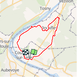
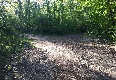
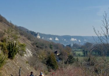
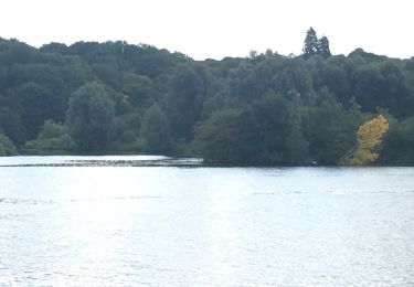
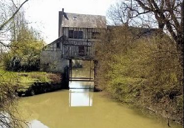
Trail Walking of 12.7 km to be discovered at Normandy, Eure, Courcelles-sur-Seine. This trail is proposed by marcel.F.

Description

boucle départ parking de la mairie de Courcelles sur Seine via Bouaffles

Elevation profile

Positioning

Country:
France
Region :
Normandy
Department/Province :
Eure
Municipality :
Courcelles-sur-Seine
Location:
Unknown
Start:(UTM)
380330 ; 5449061 (31U) N.

Comments

Please log in to post a review or rate the element


Trails nearby

Trail Walking Les Trois Lacs - rando venables - Photo
Walking
Dominique Petit

Walking

Medium
Les Trois Lacs, Normandy, Eure, France
10.9 km | 13.1 km-effort
3h 2min
Yes
Trail Walking Gaillon - Gaillon-StAubin-Brillehaut - Photo
Walking
douneto

Walking

Medium
Gaillon, Normandy, Eure, France
11.3 km | 14.7 km-effort
3h 9min
Yes
Trail Walking Villers-sur-le-Roule - Villers-Venables_13Km - Photo
Walking
douneto

Walking

Medium
Villers-sur-le-Roule, Normandy, Eure, France
11.9 km | 14.9 km-effort
3h 10min
Yes
Trail Walking Saint-Aubin-sur-Gaillon - Brillehaut_ScarabeViolet - Photo
Walking
douneto

Walking

Easy
Saint-Aubin-sur-Gaillon, Normandy, Eure, France
5.6 km | 7.1 km-effort
1h 30min
Yes
Trail Walking Muids - rando Muids  - Photo
Walking
Dominique Petit

Walking

Easy
Muids, Normandy, Eure, France
10.9 km | 12.6 km-effort
3h 13min
Yes
Trail Walking Les Trois Lacs - La Mare sous Venables - Photo
Walking
MichelRando7656

Walking

Easy
Les Trois Lacs, Normandy, Eure, France
8.5 km | 9.6 km-effort
2h 5min
No
Trail Other activity La Chapelle-Longueville - de l hôtel des canisses - Photo
Other activity
doclocjl

Other activity

Easy
La Chapelle-Longueville, Normandy, Eure, France
11.9 km | 14.3 km-effort
3h 48min
Yes
Trail Walking Muids - Muids - Le moulin - Photo
Walking
marcel.F

Walking

Easy
Muids, Normandy, Eure, France
8.7 km | 9.6 km-effort
2h 8min
Yes
Trail Walking Le Val d'Hazey - chapelle de Bethléem - Photo
Walking
bipf

Walking

Easy
Le Val d'Hazey, Normandy, Eure, France
2.7 km | 3.9 km-effort
1h 40min
Yes


Close
My subscriptions