Trail Other activity Saint-Sulpice-Laurière - Nouveau guide ST SULPICE LAILLOUX - Photo

Nouveau guide ST SULPICE LAILLOUX

© OpenStreetMap contributors
Length
Length
9 km
Max alt
Max alt
655 m
Uphill gradient
Uphill gradient
233 m
Km-Effort
Km-Effort  
11.9 km
Min alt
Min alt
473 m
Downhill gradient
Downhill gradient
152 m
Boucle
Boucle
No
Creation date :
2014-12-10 00:00:00.0
Updated on :
2014-12-10 00:00:00.0

(0 Reviews)

Other activity
Other activity
2h00
Difficulty : Unknown

Scan this QR Code to open this trail in the SityTrail application

FREE GPS app for hiking

Logo SityTrail SityTrail

IGN / Geographical institutes

Download SityTrail from the App Store Download SityTrail from Google Play

Logo SityTrail SityTrail World

The world is yours!

Download SityTrail from the App Store Download SityTrail from Google Play Download SityTrail on Huawei AppGallery

About

Trail Other activity of 9 km to be discovered at New Aquitaine, Haute-Vienne, Saint-Sulpice-Laurière. This trail is proposed by fouetillou.

Description

ST SULP.---COMBES--- lailloux

Elevation profile

Positioning

Country:
France
Region :
New Aquitaine
Department/Province :
Haute-Vienne
Municipality :
Saint-Sulpice-Laurière
Location:
Unknown
Start:(UTM)
383300 ; 5099691 (31T) N.

Trails nearby

Trail Walking La Jonchère-Saint-Maurice - la Jonchères st Maurice  - Photo
Walking
coeurdom

Walking

Difficult
La Jonchère-Saint-Maurice, New Aquitaine, Haute-Vienne, France
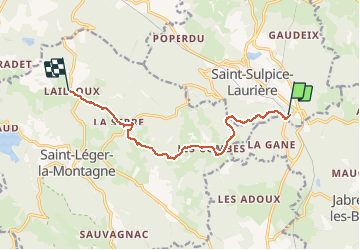
8.2 km | 12.4 km-effort
2h 20min
Yes
Trail sport Saint-Léger-la-Montagne - De Sauvagnac au relais  - Photo
sport
000843.e2af63ba812d4dc4a845c93df243350a.2104

sport

Very easy
(1)
Saint-Léger-la-Montagne, New Aquitaine, Haute-Vienne, France
3.5 km | 5 km-effort
Unknown
Yes
Trail sport Saint-Léger-la-Montagne - Sauvagnac AR par lac de Pierre Miller - Photo
sport
000843.e2af63ba812d4dc4a845c93df243350a.2104

sport

Very easy
Saint-Léger-la-Montagne, New Aquitaine, Haute-Vienne, France
14.9 km | 19.6 km-effort
Unknown
Yes
Trail Walking La Jonchère-Saint-Maurice - la jonchere - Photo
Walking
fanthou

Walking

Medium
(1)
La Jonchère-Saint-Maurice, New Aquitaine, Haute-Vienne, France
9.2 km | 13.9 km-effort
2h 55min
Yes
Trail Walking Saint-Sulpice-Laurière - Autour de Saint-Sulpice Laurière - Photo
Walking
tracegps

Walking

Difficult
Saint-Sulpice-Laurière, New Aquitaine, Haute-Vienne, France
28 km | 40 km-effort
8h 0min
Yes
Trail Horseback riding Saint-Léger-la-Montagne - Tourbière des Dauges  - Photo
Horseback riding
orsel

Horseback riding

Easy
Saint-Léger-la-Montagne, New Aquitaine, Haute-Vienne, France
4.8 km | 6.2 km-effort
2h 46min
Yes
Trail On foot Saint-Léger-la-Montagne - Tourbière des Dauges - parcours long - Photo
On foot
PRO

On foot

Easy
Saint-Léger-la-Montagne, New Aquitaine, Haute-Vienne, France
5.7 km | 7.4 km-effort
1h 41min
No
Trail Motorbike Laurière - St Goussaud-Chatelus-Murat-Mourioux-Arrènes inversé - Photo
Motorbike
bernard_ostermann

Motorbike

Medium
Laurière, New Aquitaine, Haute-Vienne, France
85 km | 107 km-effort
2h 20min
Yes
Trail Walking La Jonchère-Saint-Maurice - 202012-Puy-sauvagna - Photo
Walking
frederic.farge

Walking

La Jonchère-Saint-Maurice, New Aquitaine, Haute-Vienne, France
9 km | 13 km-effort
2h 44min
No


Close
My subscriptions