Trail Walking Saint-Martin-Vésubie - Mercantour 1 - Photo
 ilur56
ilur56

User

© OpenStreetMap contributors
Length
Length
7.6 km
Max alt
Max alt
2442 m
Uphill gradient
Uphill gradient
637 m
Km-Effort
Km-Effort  
15.7 km
Min alt
Min alt
1808 m
Downhill gradient
Downhill gradient
534 m
Boucle
Boucle
No
Creation date :
2014-12-10 00:00:00.0
Updated on :
2014-12-10 00:00:00.0

(0 Reviews)

Walking
Walking
3h06
Difficulty : Very easy

Scan this QR Code to open this trail in the SityTrail application

FREE GPS app for hiking

Logo SityTrail SityTrail

IGN / Geographical institutes

Download SityTrail from the App Store Download SityTrail from Google Play

Logo SityTrail SityTrail World

The world is yours!

Download SityTrail from the App Store Download SityTrail from Google Play Download SityTrail on Huawei AppGallery

About

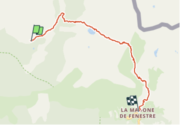
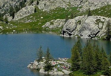
Trail Walking of 7.6 km to be discovered at Provence-Alpes-Côte d'Azur, Maritime Alps, Saint-Martin-Vésubie. This trail is proposed by ilur56.

Description

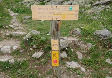
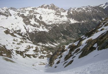
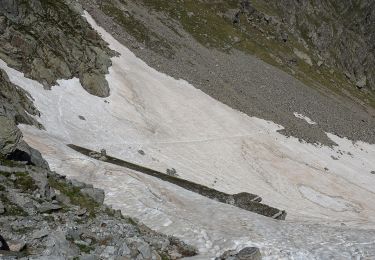
Première étape entre le village du Boréon et le refuge de Madone de Fenestre

Elevation profile

Points of interest

Point of interest Saint-Martin-Vésubie - Mon point - Photo
ilur56
SAINT-MARTIN-VÉSUBIE 
Point of interest Saint-Martin-Vésubie - Mon point - Photo
ilur56
SAINT-MARTIN-VÉSUBIE 

Positioning

Country:
France
Region :
Provence-Alpes-Côte d'Azur
Department/Province :
Maritime Alps
Municipality :
Saint-Martin-Vésubie
Location:
Unknown
Start:(UTM)
365543 ; 4885822 (32T) N.

Trails nearby

Trail Walking Saint-Martin-Vésubie - Lac de Trécolpas - Photo
Walking
patsure

Walking

Medium
(2)
Saint-Martin-Vésubie, Provence-Alpes-Côte d'Azur, Maritime Alps, France
13.3 km | 20 km-effort
4h 17min
Yes
Trail Walking Saint-Martin-Vésubie - lacs bessons - Photo
Walking
REYPatrick

Walking

Very easy
(1)
Saint-Martin-Vésubie, Provence-Alpes-Côte d'Azur, Maritime Alps, France
13.1 km | 0 m-effort
7h 36min
Yes
Trail Walking Saint-Martin-Vésubie - Lac Ne`gre bis - Photo
Walking
kenhava

Walking

Medium
(1)
Saint-Martin-Vésubie, Provence-Alpes-Côte d'Azur, Maritime Alps, France
13.1 km | 23 km-effort
3h 42min
Yes
Trail On foot Saint-Martin-Vésubie - Col de Cerise - Photo
On foot
PRO

On foot

Medium
Saint-Martin-Vésubie, Provence-Alpes-Côte d'Azur, Maritime Alps, France
9.7 km | 23 km-effort
5h 18min
Yes
Trail On foot Saint-Martin-Vésubie - Circuit de Fenestre - Photo
On foot
PRO

On foot

Easy
Saint-Martin-Vésubie, Provence-Alpes-Côte d'Azur, Maritime Alps, France
8.1 km | 16.4 km-effort
3h 44min
Yes
Trail On foot Saint-Martin-Vésubie - Circuit de Trécolpas - Photo
On foot
PRO

On foot

Easy
Saint-Martin-Vésubie, Provence-Alpes-Côte d'Azur, Maritime Alps, France
8.9 km | 15.8 km-effort
3h 35min
Yes
Trail On foot Entracque - (SI E09) Rifugio Rifugio Soria-Ellena - Rifugio Genova-Figari - Photo
On foot
PRO

On foot

Easy
Entracque, Piemont, Cuneo, Italy
7.1 km | 15.6 km-effort
3h 32min
No
Trail Walking Saint-Martin-Vésubie - Cime de l'Agnellière via Lac de Trécolpas et Pas des Ladres - Photo
Walking
michlie

Walking

Medium
(1)
Saint-Martin-Vésubie, Provence-Alpes-Côte d'Azur, Maritime Alps, France
14.4 km | 28 km-effort
5h 57min
Yes
Trail Walking Saint-Martin-Vésubie - Lacs de Prals - Photo
Walking
michlie

Walking

Easy
(1)
Saint-Martin-Vésubie, Provence-Alpes-Côte d'Azur, Maritime Alps, France
6.7 km | 13.5 km-effort
2h 48min
Yes


Close
My subscriptions