Trail Walking Pontvallain - pontvallain circuit bleu - Photo

pontvallain circuit bleu

© OpenStreetMap contributors
Length
Length
9.5 km
Max alt
Max alt
112 m
Uphill gradient
Uphill gradient
118 m
Km-Effort
Km-Effort  
11 km
Min alt
Min alt
44 m
Downhill gradient
Downhill gradient
116 m
Boucle
Boucle
Yes
Creation date :
2014-12-10 00:00:00.0
Updated on :
2014-12-10 00:00:00.0

(1 Reviews)

Walking
Walking
1h57
Difficulty : Easy

Scan this QR Code to open this trail in the SityTrail application

FREE GPS app for hiking

Logo SityTrail SityTrail

IGN / Geographical institutes

Download SityTrail from the App Store Download SityTrail from Google Play

Logo SityTrail SityTrail World

The world is yours!

Download SityTrail from the App Store Download SityTrail from Google Play Download SityTrail on Huawei AppGallery

About

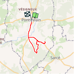
Trail Walking of 9.5 km to be discovered at Pays de la Loire, Sarthe, Pontvallain. This trail is proposed by picouleau220345.

Description

facile

Elevation profile

Photos

Points of interest

Point of interest Pontvallain - Point 4 - Photo
picouleau220345
PONTVALLAIN 
Point of interest Pontvallain - Point 6 - Photo
picouleau220345
PONTVALLAIN 
Point of interest Pontvallain - Point 8 - Photo
picouleau220345
PONTVALLAIN 
Point of interest Pontvallain - Point 11 - Photo
picouleau220345
PONTVALLAIN 
Point of interest Pontvallain - Point 14 - Photo
picouleau220345
PONTVALLAIN 
Point of interest Pontvallain - Point 16 - Photo
picouleau220345
PONTVALLAIN 
Point of interest Pontvallain - Point 20 - Photo
picouleau220345
PONTVALLAIN 
Point of interest Pontvallain - Point 21 - Photo
picouleau220345
PONTVALLAIN 

Positioning

Country:
France
Region :
Pays de la Loire
Department/Province :
Sarthe
Municipality :
Pontvallain
Location:
Unknown
Start:(UTM)
289528 ; 5292340 (31T) N.

Comments

Please log in to post a review or rate the element


Quelques très beaux passages , et de belles forêts. Merci


Trails nearby

Trail On foot Mansigné - Mansigné tour du lac 4,4kms - Photo
On foot
Jos17

On foot

Very easy
Mansigné, Pays de la Loire, Sarthe, France
4.3 km | 4.7 km-effort
Unknown
Yes
Trail Walking Mayet - GR pays entre vignes et vergers - Photo
Walking
fabiennefroger

Walking

Easy
Mayet, Pays de la Loire, Sarthe, France
15.7 km | 17.8 km-effort
3h 1min
No
Trail Road bike Mayet - Mayet L’aille - Photo
Road bike
fabiennefroger

Road bike

Medium
Mayet, Pays de la Loire, Sarthe, France
22 km | 25 km-effort
1h 22min
Yes
Trail Walking Mayet - la couperie - Photo
Walking
il2larai

Walking

Very easy
Mayet, Pays de la Loire, Sarthe, France
2.7 km | 2.9 km-effort
33min
Yes
Trail Walking Mayet - sarceau - Photo
Walking
il2larai

Walking

Very easy
Mayet, Pays de la Loire, Sarthe, France
7.4 km | 8.2 km-effort
1h 23min
Yes


Close
My subscriptions