Trail Walking Crespin - Andouquette - Photo

Andouquette

 massout
massout

User

© OpenStreetMap contributors
Length
Length
8.3 km
Max alt
Max alt
537 m
Uphill gradient
Uphill gradient
248 m
Km-Effort
Km-Effort  
11.6 km
Min alt
Min alt
308 m
Downhill gradient
Downhill gradient
248 m
Boucle
Boucle
Yes
Creation date :
2015-02-28 00:00:00.0
Updated on :
2015-02-28 00:00:00.0

(2 Reviews)

Walking
Walking
2h32
Difficulty : Medium

Scan this QR Code to open this trail in the SityTrail application

FREE GPS app for hiking

Logo SityTrail SityTrail

IGN / Geographical institutes

Download SityTrail from the App Store Download SityTrail from Google Play

Logo SityTrail SityTrail World

The world is yours!

Download SityTrail from the App Store Download SityTrail from Google Play Download SityTrail on Huawei AppGallery

About

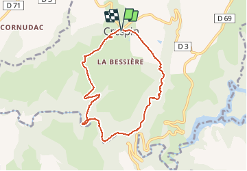
Trail Walking of 8.3 km to be discovered at Occitania, Tarn, Crespin. This trail is proposed by massout.

Elevation profile

Positioning

Country:
France
Region :
Occitania
Department/Province :
Tarn
Municipality :
Crespin
Location:
Unknown
Start:(UTM)
443780 ; 4877798 (31T) N.

Comments

Please log in to post a review or rate the element


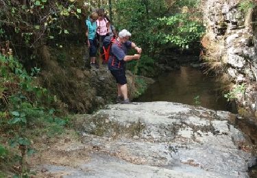
très agréable randonnée on longe un cours d'eau...


beau circuit avec quelques passages difficiles au bord du torrent


Trails nearby

Trail Walking Padiès - Padies / Saint Gėraud - Photo
Walking
tercla

Walking

Difficult
(1)
Padiès, Occitania, Tarn, France
10.6 km | 15.2 km-effort
3h 15min
Yes
Trail On foot Crespin - Sentier de l’Andouquette - Photo
On foot
PRO

On foot

Easy
Crespin, Occitania, Tarn, France
7.7 km | 10.9 km-effort
2h 28min
Yes
Trail Walking Moularès - grand huit La Vierge - Photo
Walking
ravailhe

Walking

Difficult
Moularès, Occitania, Tarn, France
10.5 km | 13.6 km-effort
2h 54min
Yes
Trail Walking Crespin - Crespin 13 gués - Photo
Walking
pidjam

Walking

Very easy
Crespin, Occitania, Tarn, France
8.6 km | 11.9 km-effort
2h 26min
Yes
Trail Mountain bike Moularès - moulares 2012 - Photo
Mountain bike
J-Mi

Mountain bike

Medium
Moularès, Occitania, Tarn, France
43 km | 55 km-effort
3h 11min
Yes
Trail Walking Moularès - 81_Moulares_courte - Photo
Walking
jab31

Walking

Difficult
Moularès, Occitania, Tarn, France
14.2 km | 18.4 km-effort
5h 30min
Yes
Trail Walking Moularès - 81_Moulares_longue - Photo
Walking
jab31

Walking

Difficult
Moularès, Occitania, Tarn, France
23 km | 29 km-effort
5h 30min
Yes
Trail Walking Saint-Jean-de-Marcel - Saint Jean Marcel par le pont de Maux - Photo
Walking
tercla

Walking

Very easy
(1)
Saint-Jean-de-Marcel, Occitania, Tarn, France
9.4 km | 12.3 km-effort
3h 5min
Yes
Trail Walking Moularès - 2019 grand 8 graumond - Photo
Walking
ravailhe

Walking

Difficult
Moularès, Occitania, Tarn, France
13.8 km | 17.7 km-effort
3h 47min
Yes


Close
My subscriptions