Trail Walking Bâgé-Dommartin - Dommartin: le Circuit des Nénuphars - Photo

Dommartin: le Circuit des Nénuphars

© OpenStreetMap contributors
Length
Length
6.5 km
Max alt
Max alt
214 m
Uphill gradient
Uphill gradient
52 m
Km-Effort
Km-Effort  
7.2 km
Min alt
Min alt
185 m
Downhill gradient
Downhill gradient
53 m
Boucle
Boucle
Yes
Creation date :
2014-12-10 00:00:00.0
Updated on :
2014-12-10 00:00:00.0

(0 Reviews)

Walking
Walking
1h36
Difficulty : Very easy

Scan this QR Code to open this trail in the SityTrail application

FREE GPS app for hiking

Logo SityTrail SityTrail

IGN / Geographical institutes

Download SityTrail from the App Store Download SityTrail from Google Play

Logo SityTrail SityTrail World

The world is yours!

Download SityTrail from the App Store Download SityTrail from Google Play Download SityTrail on Huawei AppGallery

About

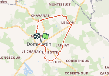
Trail Walking of 6.5 km to be discovered at Auvergne-Rhône-Alpes, Ain, Bâgé-Dommartin. This trail is proposed by robertdurand.

Description

Randonnées au Pays de Bâgé: en empruntant le circuit des Nénuphars vous découvrirez l'église de Dommartin ainsi que plusieurs calvaires.

Elevation profile

Positioning

Country:
France
Region :
Auvergne-Rhône-Alpes
Department/Province :
Ain
Municipality :
Bâgé-Dommartin
Location:
Unknown
Start:(UTM)
653192 ; 5133511 (31T) N.

Trails nearby

Trail Walking Chevroux - Chevroux - Photo
Walking
robertdurand

Walking

Medium
Chevroux, Auvergne-Rhône-Alpes, Ain, France
6.7 km | 7.4 km-effort
1h 36min
Yes
Trail Walking Saint-Sulpice - Ballades des Papilles 2013à St Didier D'Aussiat - Photo
Walking
robertdurand

Walking

Medium
Saint-Sulpice, Auvergne-Rhône-Alpes, Ain, France
15.7 km | 17.9 km-effort
3h 55min
Yes
Trail Walking Bâgé-Dommartin - DOMMARTIN: Circuit Épaisse - Photo
Walking
robertdurand

Walking

Medium
Bâgé-Dommartin, Auvergne-Rhône-Alpes, Ain, France
16.1 km | 18 km-effort
4h 8min
Yes
Trail Walking Bâgé-Dommartin - DOMMARTIN: Circuit Épaisse - Photo
Walking
robertdurand

Walking

Medium
Bâgé-Dommartin, Auvergne-Rhône-Alpes, Ain, France
16.1 km | 18 km-effort
4h 8min
Yes
Trail Walking Bâgé-Dommartin - DOMMARTIN: Circuit de la Pérouse - Photo
Walking
robertdurand

Walking

Easy
Bâgé-Dommartin, Auvergne-Rhône-Alpes, Ain, France
7.7 km | 8.7 km-effort
1h 55min
Yes
Trail Walking Bâgé-le-Châtel - Bâgé-la Ville: Pailladières - Photo
Walking
robertdurand

Walking

Difficult
Bâgé-le-Châtel, Auvergne-Rhône-Alpes, Ain, France
27 km | 30 km-effort
7h 2min
Yes
Trail Walking Bâgé-le-Châtel - Bâgé-le Chatel: les 3 Châteaux - Photo
Walking
robertdurand

Walking

Easy
Bâgé-le-Châtel, Auvergne-Rhône-Alpes, Ain, France
11.1 km | 12.9 km-effort
2h 30min
Yes
Trail On foot Chevroux - CHEVROUX - Photo
On foot
Bonsaicd

On foot

Easy
Chevroux, Auvergne-Rhône-Alpes, Ain, France
12.5 km | 13.9 km-effort
3h 9min
Yes
Trail Walking Saint-Cyr-sur-Menthon - muguet - Photo
Walking
Denis01

Walking

Easy
Saint-Cyr-sur-Menthon, Auvergne-Rhône-Alpes, Ain, France
1.9 km | 2.2 km-effort
1h 0min
Yes


Close
My subscriptions