Trail Walking Terre-de-Haut - Les Saintes - Photo
 sphinkie
sphinkie

User

© OpenStreetMap contributors
Length
Length
16.3 km
Max alt
Max alt
295 m
Uphill gradient
Uphill gradient
630 m
Km-Effort
Km-Effort  
25 km
Min alt
Min alt
1 m
Downhill gradient
Downhill gradient
636 m
Boucle
Boucle
Yes
Creation date :
2016-03-09 00:00:00.0
Updated on :
2016-03-09 00:00:00.0

(0 Reviews)

Walking
Walking
5h26
Difficulty : Medium

Scan this QR Code to open this trail in the SityTrail application

FREE GPS app for hiking

Logo SityTrail SityTrail

IGN / Geographical institutes

Download SityTrail from the App Store Download SityTrail from Google Play

Logo SityTrail SityTrail World

The world is yours!

Download SityTrail from the App Store Download SityTrail from Google Play Download SityTrail on Huawei AppGallery

About

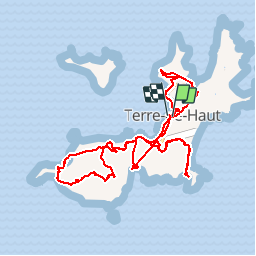
Trail Walking of 16.3 km to be discovered at Guadeloupe, Unknown, Terre-de-Haut. This trail is proposed by sphinkie.

Description

Visite de l'Ile de Terre de Haut (Les Saintes), en vélo et à pied.

Elevation profile

Photos

Positioning

Country:
France
Region :
Guadeloupe
Department/Province :
Unknown
Municipality :
Terre-de-Haut
Location:
Unknown
Start:(UTM)
651814 ; 1754814 (20P) N.

Trails nearby

Trail Walking Terre-de-Bas - terre de bas rouge et bleue - Photo
Walking
Yannick971

Walking

Medium
Terre-de-Bas, Guadeloupe, Unknown, France
3.6 km | 6.4 km-effort
2h 2min
No
Trail Walking Terre-de-Haut - cascade tambour  - Photo
Walking
Gerty Dhaussy

Walking

Very easy
Terre-de-Haut, Guadeloupe, Unknown, France
42 km | 68 km-effort
3h 47min
No
Trail Walking Terre-de-Haut - Morne du chameau - les saintes - Photo
Walking
jps13

Walking

Very difficult
Terre-de-Haut, Guadeloupe, Unknown, France
6.4 km | 11.5 km-effort
1h 27min
No
Trail Walking Terre-de-Bas - Anse à dos par route du Nord de Terre de Bas - Photo
Walking
guiller

Walking

Easy
Terre-de-Bas, Guadeloupe, Unknown, France
4.5 km | 7.3 km-effort
1h 21min
No
Trail Walking Terre-de-Haut - Le Chameau Terre de haut - Photo
Walking
Jean-Marc Golberg

Walking

Medium
Terre-de-Haut, Guadeloupe, Unknown, France
2.6 km | 6.2 km-effort
1h 46min
Yes
Trail Walking Terre-de-Bas - saintes trace jaune  - Photo
Walking
bruno lohest

Walking

Medium
Terre-de-Bas, Guadeloupe, Unknown, France
6.8 km | 11.4 km-effort
3h 15min
Yes
Trail Trail Terre-de-Haut - activity_10055340498 - Photo
Trail
loic09

Trail

Very easy
Terre-de-Haut, Guadeloupe, Unknown, France
9.5 km | 15 km-effort
Unknown
Yes
Trail Walking Terre-de-Haut - Station Morel  - Photo
Walking
Sébastien Duffes

Walking

Medium
Terre-de-Haut, Guadeloupe, Unknown, France
2.3 km | 3 km-effort
1h 25min
Yes
Trail On foot Terre-de-Haut - Découverte de la Terre-des-Hauts de l'archipel des Saintes  - Photo
On foot
Jo-Guide

On foot

Easy
Terre-de-Haut, Guadeloupe, Unknown, France
10.7 km | 17 km-effort
3h 52min
Yes


Close
My subscriptions