Trail Walking Castelnau-Pégayrols - castelnau pegayrols  - Photo
 nanie
nanie

User

© OpenStreetMap contributors
Length
Length
7.5 km
Max alt
Max alt
761 m
Uphill gradient
Uphill gradient
334 m
Km-Effort
Km-Effort  
11.9 km
Min alt
Min alt
501 m
Downhill gradient
Downhill gradient
335 m
Boucle
Boucle
Yes
Creation date :
2014-12-10 00:00:00.0
Updated on :
2014-12-10 00:00:00.0

(3 Reviews)

Walking
Walking
2h32
Difficulty : Medium

Scan this QR Code to open this trail in the SityTrail application

FREE GPS app for hiking

Logo SityTrail SityTrail

IGN / Geographical institutes

Download SityTrail from the App Store Download SityTrail from Google Play

Logo SityTrail SityTrail World

The world is yours!

Download SityTrail from the App Store Download SityTrail from Google Play Download SityTrail on Huawei AppGallery

About

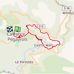
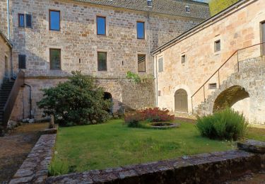
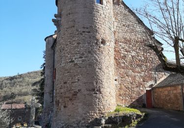
Trail Walking of 7.5 km to be discovered at Occitania, Aveyron, Castelnau-Pégayrols. This trail is proposed by nanie.

Description

départ Castelnau descente vers le ruisseau la muse montée à Castelmus...

Elevation profile

Positioning

Country:
France
Region :
Occitania
Department/Province :
Aveyron
Municipality :
Castelnau-Pégayrols
Location:
Unknown
Start:(UTM)
494430 ; 4886330 (31T) N.

Comments

Please log in to post a review or rate the element


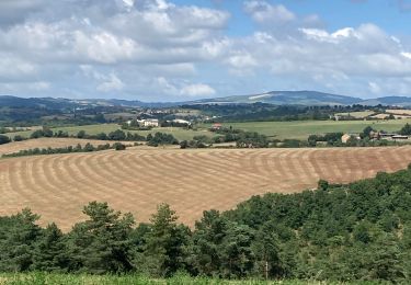
il est vrai que le GPS s' affole dans les lacets. Mais ce beau circuit est balisé en jaune.


dommage le tracer ne correspond pas trop avec la ballade


Trails nearby

Trail Walking Saint-Beauzély - Azinieres - Photo
Walking
Sandrine Micou

Walking

Medium
Saint-Beauzély, Occitania, Aveyron, France
17.4 km | 22 km-effort
4h 57min
Yes
Trail Running Saint-Beauzély - Trail de la Muse - Saint Beauzély - Photo
Running
tracegps

Running

Difficult
Saint-Beauzély, Occitania, Aveyron, France
24 km | 36 km-effort
3h 30min
Yes
Trail Walking Saint-Beauzély - Trail de la Muse - Saint Beauzély - Photo
Walking
tracegps

Walking

Difficult
Saint-Beauzély, Occitania, Aveyron, France
24 km | 36 km-effort
5h 30min
Yes
Trail Walking Saint-Beauzély - Azinières, les dix Cazelles  - Photo
Walking
tracegps

Walking

Medium
(2)
Saint-Beauzély, Occitania, Aveyron, France
13.1 km | 17.2 km-effort
3h 30min
Yes
Trail Walking Castelnau-Pégayrols - 2021-09-05 Sahut -Col de Poulzinières - Photo
Walking
EricRoulin

Walking

Medium
Castelnau-Pégayrols, Occitania, Aveyron, France
16 km | 21 km-effort
4h 50min
Yes
Trail Walking Viala-du-Tarn - st symphorien sud - Photo
Walking
CASSISFRAMBOISE

Walking

Medium
Viala-du-Tarn, Occitania, Aveyron, France
6.3 km | 9.7 km-effort
1h 25min
Yes
Trail Walking Saint-Beauzély - St beauz  cloître beaumette St b - Photo
Walking
lablaquiere

Walking

Difficult
(1)
Saint-Beauzély, Occitania, Aveyron, France
8.5 km | 12.5 km-effort
1h 46min
Yes
Trail Running Castelnau-Pégayrols - moulibez castelneau peg castelmus moulibez - Photo
Running
lablaquiere

Running

Very easy
Castelnau-Pégayrols, Occitania, Aveyron, France
10.6 km | 15.7 km-effort
2h 6min
Yes
Trail On foot Comprégnac - Sentier des Cazelles Comprégnac - Photo
On foot
PRO

On foot

Easy
Comprégnac, Occitania, Aveyron, France
6.4 km | 10.6 km-effort
2h 24min
Yes


Close
My subscriptions