Trail Equestrian Alles-sur-Dordogne - 2013-04-21 Rando CVA Dordogne - Photo

2013-04-21 Rando CVA Dordogne

 holtzv
holtzv

User GUIDE

© OpenStreetMap contributors
Length
Length
36 km
Max alt
Max alt
230 m
Uphill gradient
Uphill gradient
758 m
Km-Effort
Km-Effort  
45 km
Min alt
Min alt
46 m
Downhill gradient
Downhill gradient
630 m
Boucle
Boucle
No
Creation date :
2014-12-10 00:00:00.0
Updated on :
2014-12-10 00:00:00.0

(0 Reviews)

Equestrian
Equestrian
5h40
Difficulty : Medium

Scan this QR Code to open this trail in the SityTrail application

FREE GPS app for hiking

Logo SityTrail SityTrail

IGN / Geographical institutes

Download SityTrail from the App Store Download SityTrail from Google Play

Logo SityTrail SityTrail World

The world is yours!

Download SityTrail from the App Store Download SityTrail from Google Play Download SityTrail on Huawei AppGallery

About

Trail Equestrian of 36 km to be discovered at New Aquitaine, Dordogne, Alles-sur-Dordogne. This trail is proposed by holtzv.

Description

Départ : La Haute Yerle
Arrivée : Auberge la Taulado

Elevation profile

Points of interest

Point of interest Alles-sur-Dordogne - Ferme La Haute Yerle - Photo
holtzv
ALLES-SUR-DORDOGNE 
Point of interest Les Eyzies - Auberge La Taulado - Photo
holtzv
LES EYZIES 
Point of interest Les Eyzies - Repas de midi - Photo
holtzv
LES EYZIES 

Positioning

Country:
France
Region :
New Aquitaine
Department/Province :
Dordogne
Municipality :
Alles-sur-Dordogne
Location:
Unknown
Start:(UTM)
331591 ; 4971051 (31T) N.

Trails nearby

Trail Walking Paunat - Boucle Paunat - Limeuil - Photo
Walking
lacostej

Walking

Medium
(1)
Paunat, New Aquitaine, Dordogne, France
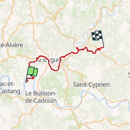
18.8 km | 25 km-effort
3h 35min
Yes
Trail Electric bike Alles-sur-Dordogne - La balade de l’ascension  - Photo
Electric bike
ORTAX

Electric bike

Medium
Alles-sur-Dordogne, New Aquitaine, Dordogne, France
34 km | 42 km-effort
2h 16min
No
Trail Walking Limeuil - Limeuil - Photo
Walking
neitag61

Walking

Easy
(1)
Limeuil, New Aquitaine, Dordogne, France
9.1 km | 10.9 km-effort
2h 30min
Yes
Trail Walking Trémolat - Circuit de la Plaine à Trémolat - Photo
Walking
tracegps

Walking

Medium
(1)
Trémolat, New Aquitaine, Dordogne, France
9.8 km | 12.1 km-effort
2h 30min
Yes
Trail Walking Trémolat - Circuit du Cingle à Trémolat - Photo
Walking
tracegps

Walking

Easy
(3)
Trémolat, New Aquitaine, Dordogne, France
6.7 km | 9 km-effort
1h 45min
Yes
Trail Walking Val de Louyre et Caudeau - Pezuls 10,5km - Photo
Walking
amelie14

Walking

Medium
Val de Louyre et Caudeau, New Aquitaine, Dordogne, France
10.5 km | 13.3 km-effort
1h 54min
Yes
Trail Walking Paunat - swwpaunat - Photo
Walking
michel calvo 2

Walking

Medium
Paunat, New Aquitaine, Dordogne, France
10.5 km | 14.2 km-effort
2h 40min
Yes
Trail Walking Paunat - Trėmolat 10,1km - Photo
Walking
amelie14

Walking

Medium
Paunat, New Aquitaine, Dordogne, France
10.1 km | 13.8 km-effort
2h 8min
Yes
Trail Walking Le Buisson-de-Cadouin - Le Buisson de C. 14km - Photo
Walking
amelie14

Walking

Medium
Le Buisson-de-Cadouin, New Aquitaine, Dordogne, France
13.6 km | 18.1 km-effort
2h 50min
Yes


Close
My subscriptions